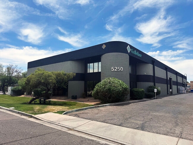
Property Record
5250 S 31St Pl, Phoenix, AZ 85040


Current Lease Availabilities
Property Detail
5250 S 31St Pl
122-62-023
SOUTHERN GARDEN INDUSTRIAL PARK PHASE FOUR 64-94 MCR 300-18
Warehouse
Maricopa
I-P
Arizona
C and X Area of minimal flood hazard, usually depicted on FIRMs as above the 500-year flood level.
82
2025
1.01 AC
2025
S Airport S of Roeser
116100
Phoenix
16,080 SF
Phoenix-Mesa-Chandler, AZ
NEARBY LISTINGS FOR SALE OR LEASE
DEMOGRAPHICS near 5250 S 31St Pl
1 mile
3 mile
5 mile
2025 Total Population
9,280
72,319
276,867
2030 Population
9,712
74,964
288,089
Pop Growth 2025-2030
+ 4.66%
+ 3.66%
+ 4.05%
Average Age
32
36
35
2025 Total Households
3,059
24,633
100,910
HH Growth 2025-2030
+ 4.71%
+ 3.78%
+ 4.21%
Median Household Inc
$73,940
$74,117
$68,034
Avg Household Size
3.00
2.80
2.60
2025 Avg HH Vehicles
2.00
2.00
2.00
Median Home Value
$376,386
$369,191
$389,222
Median Year Built
1997
1987
1985
Nearby Places
Map Layers
Map Styles
 Street
 Aerial
Layers
 Traffic
 Biking
Places
Listings with unknown addresses are not visible on the map
- Restaurants
- Banks
- Shops
- Fitness
- Groceries
PUBLIC TRANSPORTATION
AIRPORT
Phoenix Sky Harbor International
Drive
Walk
Distance
Phoenix Sky Harbor International
11 min
5.7 mi
Phoenix-Mesa Gateway
Drive
Walk
Distance
Phoenix-Mesa Gateway
38 min
27.7 mi
Freight Ports
Port of San Diego
Drive
Walk
Distance
Port of San Diego
403 min
369.0 mi
Nearby Properties
Address
Land Use
TOTAL SIZE
Lot Size
Zoning
Address
Land Use
TOTAL SIZE
Lot Size
Zoning
12.93 AC
I-P
Address
Land Use
TOTAL SIZE
Lot Size
Zoning
2,901,193 SF
20.73 AC
A-1
Address
Land Use
TOTAL SIZE
Lot Size
Zoning
1,949,842 SF
40 AC
I-1
Address
Land Use
TOTAL SIZE
Lot Size
Zoning
2,705,875 SF
133.42 AC
I-1
Address
Land Use
TOTAL SIZE
Lot Size
Zoning
81,816 SF
7.95 AC
Address
Land Use
TOTAL SIZE
Lot Size
Zoning
94,162 SF
9.40 AC
I-2
Address
Land Use
TOTAL SIZE
Lot Size
Zoning
Address
Land Use
TOTAL SIZE
Lot Size
Zoning
10,776 SF
10.14 AC
C-C
Address
Land Use
TOTAL SIZE
Lot Size
Zoning
1,020,776 SF
11.33 AC
I-1
Address
Land Use
TOTAL SIZE
Lot Size
Zoning
331,050 SF
39 AC
I-1
Address
Land Use
TOTAL SIZE
Lot Size
Zoning
32,968 SF
2.10 AC
I-P
Address
Land Use
TOTAL SIZE
Lot Size
Zoning
635,169 SF
92.76 AC
I-1
Address
Land Use
TOTAL SIZE
Lot Size
Zoning
13.72 AC
Address
Land Use
TOTAL SIZE
Lot Size
Zoning
469,025 SF
199.15 AC
A-1
Address
Land Use
TOTAL SIZE
Lot Size
Zoning
277,910 SF
53.82 AC
A-1
Address
Land Use
TOTAL SIZE
Lot Size
Zoning
359,401 SF
96.70 AC
R-6
Address
Land Use
TOTAL SIZE
Lot Size
Zoning
25,289 SF
2.70 AC
I-2
Address
Land Use
TOTAL SIZE
Lot Size
Zoning
369,723 SF
19.41 AC
R3
Address
Land Use
TOTAL SIZE
Lot Size
Zoning
180,690 SF
11.20 AC
I-P
Address
Land Use
TOTAL SIZE
Lot Size
Zoning
351,199 SF
22.04 AC
I-1
Address
Land Use
TOTAL SIZE
Lot Size
Zoning
586,083 SF
69.82 AC
Address
Land Use
TOTAL SIZE
Lot Size
Zoning
494,504 SF
18.83 AC
I-1
Address
Land Use
TOTAL SIZE
Lot Size
Zoning
40 AC
I-1
Address
Land Use
TOTAL SIZE
Lot Size
Zoning
309.82 AC
R-35
Address
Land Use
TOTAL SIZE
Lot Size
Zoning
301,102 SF
27.45 AC
Address
Land Use
TOTAL SIZE
Lot Size
Zoning
309,057 SF
7.62 AC
I-1
Address
Land Use
TOTAL SIZE
Lot Size
Zoning
734,975 SF
10.53 AC
Address
Land Use
TOTAL SIZE
Lot Size
Zoning
269,181 SF
78.11 AC
I-1
Address
Land Use
TOTAL SIZE
Lot Size
Zoning
320,708 SF
16.25 AC
A1
Address
Land Use
TOTAL SIZE
Lot Size
Zoning
353,363 SF
21.29 AC
A-1
The World's #1 Commercial Real Estate Marketplace
Connect with us
© 2026 CoStar Group
The information above has been obtained from sources believed reliable. While we do not doubt its accuracy we have not verified it and make no guarantee, warranty or representation about it. It is your responsibility to independently confirm its accuracy and completeness. Any projections, opinions, assumptions, or estimates used are for example only and do not represent the current or future performance of the property. The value of this transaction to you depends on tax and other factors which should be evaluated by your tax, financial, and legal advisors. You and your advisors should conduct a careful, independent investigation of the property to determine to your satisfaction the suitability of the property for your needs.