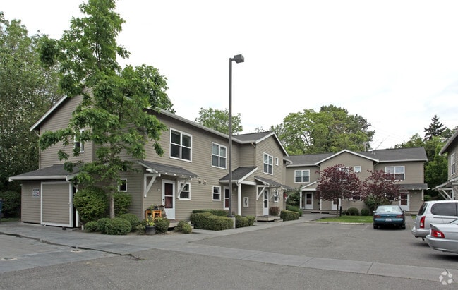
Property Record
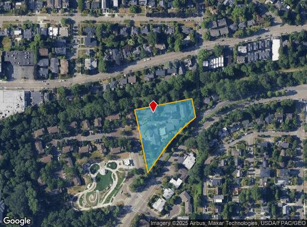
5251 Sand Point Way Ne, Seattle, WA 98105
NEARBY LISTINGS FOR SALE OR LEASE
Property Detail
5251 Sand Point Way Ne
Seattle-Tacoma-Bellevue, WA
State Land Comm Plat Sec 10-25-4
797470-0252
STATE LAND COMM PLAT SEC 10-25-4 PCL A SEA SP #83-362 REC #8808040651 SD SP DAF THAT POR TR 50 TR 52 & TR 53 STATE OF WASH COMM OF PUB LANDS SUBD OF NE 1/4 E 1/2 OF NW 1/4 & NE 1/4 OF SW 1/4 SEC 10-25-4 LY NWLY OF SAND PT WY NE & DAF: BEG NXN N MGN N
Apartment
King
X
Washington
53033C0345G
50&53
2021
1.43 AC
2024
Bryant
004201
Seattle/Puget Sound
21,714 SF
DEMOGRAPHICS near 5251 Sand Point Way Ne
1 Mile
3 Mile
5 Mile
2024 Total Population
22,524
148,877
563,657
2029 Population
22,615
150,478
572,608
Pop Growth 2024-2029
+ 0.40%
+ 1.08%
+ 1.59%
Average Age
39
37
38
2024 Total Households
8,515
62,673
274,220
HH Growth 2024-2029
+ 0.34%
+ 1.20%
+ 1.67%
Median Household Inc
$185,283
$123,292
$117,374
Avg Household Size
2.50
2.20
1.90
2024 Avg HH Vehicles
2.00
1.00
1.00
Median Home Value
$1,082,427
$1,042,253
$969,889
Median Year Built
1952
1962
1981
Nearby Places
Map Layers
Map Styles
 Street
 Aerial
- Restaurants
- Banks
- Shops
- Fitness
- Groceries
PUBLIC TRANSPORTATION
COMMUTER RAIL
King Street (Seattle) Station (Sounder South Line - Central Puget Sound Regional Transit Authority Rail (Link Light Rail/Sounder))
DRIVE
WALK
Distance
King Street (Seattle) Station (Sounder South Line - Central Puget Sound Regional Transit Authority Rail (Link Light Rail/Sounder))
14 min
7.1 mi
AIRPORT
Seattle-Tacoma International
DRIVE
WALK
Distance
Seattle-Tacoma International
25 min
19.2 mi
Freight Ports
Port of Seattle
DRIVE
WALK
Distance
Port of Seattle
1 min
7.6 mi
Nearby Properties
Address
Land Use
TOTAL SIZE
Lot Size
Zoning
Address
Land Use
TOTAL SIZE
Lot Size
Zoning
471.20 AC
MIO-37-LR1
Address
Land Use
TOTAL SIZE
Lot Size
Zoning
26,850 SF
194.66 AC
NR2
Address
Land Use
TOTAL SIZE
Lot Size
Zoning
107.86 AC
NR2
Address
Land Use
TOTAL SIZE
Lot Size
Zoning
50,060 SF
96.12 AC
NR2
Address
Land Use
TOTAL SIZE
Lot Size
Zoning
612,844 SF
0.09 AC
SM-U/R 75-
Address
Land Use
TOTAL SIZE
Lot Size
Zoning
90,184 SF
16.66 AC
C1-75 (M)
Address
Land Use
TOTAL SIZE
Lot Size
Zoning
107.93 AC
NR3
Address
Land Use
TOTAL SIZE
Lot Size
Zoning
301,245 SF
22.34 AC
LR3 (M)
Address
Land Use
TOTAL SIZE
Lot Size
Zoning
25,735 SF
1.56 AC
C1-75 (M)
Address
Land Use
TOTAL SIZE
Lot Size
Zoning
285,140 SF
0.90 AC
NC2-75 (M1
Address
Land Use
TOTAL SIZE
Lot Size
Zoning
131,790 SF
0.37 AC
SM-U 75-24
Address
Land Use
TOTAL SIZE
Lot Size
Zoning
6.87 AC
MIO-200-C1
Address
Land Use
TOTAL SIZE
Lot Size
Zoning
126,394 SF
8.80 AC
C2-75 (M)
Address
Land Use
TOTAL SIZE
Lot Size
Zoning
223,047 SF
0.18 AC
NC2P-75 (M
Address
Land Use
TOTAL SIZE
Lot Size
Zoning
382,762 SF
7.14 AC
NR3
Address
Land Use
TOTAL SIZE
Lot Size
Zoning
0.31 AC
SM-U 95-32
Address
Land Use
TOTAL SIZE
Lot Size
Zoning
132,183 SF
0.76 AC
NC2-65
Address
Land Use
TOTAL SIZE
Lot Size
Zoning
1,100 SF
18.83 AC
UI U/45
Address
Land Use
TOTAL SIZE
Lot Size
Zoning
6,534 SF
0.55 AC
IC-65 (M)
Address
Land Use
TOTAL SIZE
Lot Size
Zoning
205,000 SF
13.89 AC
NR3
Address
Land Use
TOTAL SIZE
Lot Size
Zoning
215,468 SF
0.60 AC
NC2-75 (M1
Address
Land Use
TOTAL SIZE
Lot Size
Zoning
2,874 SF
21.94 AC
NR3
Address
Land Use
TOTAL SIZE
Lot Size
Zoning
160,593 SF
1.57 AC
NC3P-75 (M
Address
Land Use
TOTAL SIZE
Lot Size
Zoning
184,251 SF
10.02 AC
LR3 (M)
Address
Land Use
TOTAL SIZE
Lot Size
Zoning
118,341 SF
0.55 AC
C2-75 (M)
Address
Land Use
TOTAL SIZE
Lot Size
Zoning
133,896 SF
0.82 AC
SM-U 95-32
Address
Land Use
TOTAL SIZE
Lot Size
Zoning
0.75 AC
SM-U 95-32
Address
Land Use
TOTAL SIZE
Lot Size
Zoning
336,254 SF
0.45 AC
SM-U 95-32
The World's #1 Commercial Real Estate Marketplace
Connect with us
© 2025 CoStar Group
The information above has been obtained from sources believed reliable. While we do not doubt its accuracy we have not verified it and make no guarantee, warranty or representation about it. It is your responsibility to independently confirm its accuracy and completeness. Any projections, opinions, assumptions, or estimates used are for example only and do not represent the current or future performance of the property. The value of this transaction to you depends on tax and other factors which should be evaluated by your tax, financial, and legal advisors. You and your advisors should conduct a careful, independent investigation of the property to determine to your satisfaction the suitability of the property for your needs.