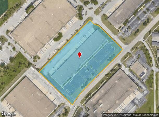
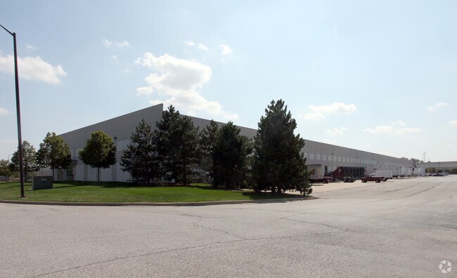
Property Record
5252 Decatur Blvd, Indianapolis, IN 46241

Current Lease Availabilities
NEARBY LISTINGS FOR SALE OR LEASE
Property Detail
5252 Decatur Blvd
49-13-03-111-002.000-200
PT NE1/4 S3 T14 R2 533.76 W, 1832.69 SW & 681 SE OF NE COR P.O.B. NE842 SE60 NE ARC90.65 SE368.12 SW623.41 SE246.12 NW544.43 TO BEG 10.22 AC
Warehouse
Marion
X
Indiana
18097C0220F
10.22 AC
2023
Airport
2024
Indianapolis
390802
Indianapolis-Carmel-Anderson, IN
119,560 SF
DEMOGRAPHICS near 5252 Decatur Blvd
1 Mile
3 Mile
5 Mile
2024 Total Population
2,462
23,648
80,806
2029 Population
2,405
23,252
81,851
Pop Growth 2024-2029
(2.32%)
(1.67%)
+ 1.29%
Average Age
34
36
36
2024 Total Households
895
8,450
29,500
HH Growth 2024-2029
(2.35%)
(1.74%)
+ 1.48%
Median Household Inc
$72,925
$70,180
$66,363
Avg Household Size
2.70
2.70
2.70
2024 Avg HH Vehicles
2.00
2.00
2.00
Median Home Value
$175,581
$166,779
$162,811
Median Year Built
1997
1991
1988
Nearby Places
- Restaurants
- Banks
- Shops
- Fitness
- Groceries
PUBLIC TRANSPORTATION
AIRPORT
Indianapolis International
DRIVE
WALK
Distance
Indianapolis International
15 min
5.7 mi
Nearby Properties
Address
Land Use
TOTAL SIZE
Lot Size
Zoning
Address
Land Use
TOTAL SIZE
Lot Size
Zoning
911,062 SF
54.40 AC
ZO01
Address
Land Use
TOTAL SIZE
Lot Size
Zoning
950,625 SF
58.11 AC
Address
Land Use
TOTAL SIZE
Lot Size
Zoning
41.50 AC
Address
Land Use
TOTAL SIZE
Lot Size
Zoning
822,500 SF
45.66 AC
Address
Land Use
TOTAL SIZE
Lot Size
Zoning
770,712 SF
56.53 AC
Address
Land Use
TOTAL SIZE
Lot Size
Zoning
702,000 SF
42.11 AC
Address
Land Use
TOTAL SIZE
Lot Size
Zoning
702,000 SF
36.88 AC
Address
Land Use
TOTAL SIZE
Lot Size
Zoning
747,256 SF
41.32 AC
Address
Land Use
TOTAL SIZE
Lot Size
Zoning
665,724 SF
47.25 AC
ZO01
Address
Land Use
TOTAL SIZE
Lot Size
Zoning
798,160 SF
44.46 AC
ZO01
Address
Land Use
TOTAL SIZE
Lot Size
Zoning
595,938 SF
35.31 AC
Address
Land Use
TOTAL SIZE
Lot Size
Zoning
997,763 SF
65.80 AC
ZO01
Address
Land Use
TOTAL SIZE
Lot Size
Zoning
292,315 SF
28.97 AC
Address
Land Use
TOTAL SIZE
Lot Size
Zoning
695,702 SF
39.68 AC
ZO03
Address
Land Use
TOTAL SIZE
Lot Size
Zoning
462,275 SF
25.83 AC
ZO01
Address
Land Use
TOTAL SIZE
Lot Size
Zoning
7,028 SF
25.48 AC
ZO01
Address
Land Use
TOTAL SIZE
Lot Size
Zoning
434,240 SF
26.25 AC
ZO01
Address
Land Use
TOTAL SIZE
Lot Size
Zoning
442,201 SF
21.48 AC
Address
Land Use
TOTAL SIZE
Lot Size
Zoning
297,040 SF
22.26 AC
Address
Land Use
TOTAL SIZE
Lot Size
Zoning
383,727 SF
25.26 AC
Address
Land Use
TOTAL SIZE
Lot Size
Zoning
423,757 SF
28.71 AC
Address
Land Use
TOTAL SIZE
Lot Size
Zoning
465,480 SF
34.07 AC
Address
Land Use
TOTAL SIZE
Lot Size
Zoning
23.17 AC
Address
Land Use
TOTAL SIZE
Lot Size
Zoning
366,600 SF
29.05 AC
ZO01
Address
Land Use
TOTAL SIZE
Lot Size
Zoning
328,331 SF
39.63 AC
ZO01
Address
Land Use
TOTAL SIZE
Lot Size
Zoning
381,340 SF
15.72 AC
Address
Land Use
TOTAL SIZE
Lot Size
Zoning
380,155 SF
17.02 AC
Address
Land Use
TOTAL SIZE
Lot Size
Zoning
3,394 SF
25.27 AC
ZO01
Address
Land Use
TOTAL SIZE
Lot Size
Zoning
340,080 SF
16.82 AC
Address
Land Use
TOTAL SIZE
Lot Size
Zoning
262,710 SF
19.50 AC
The World's #1 Commercial Real Estate Marketplace
Connect with us
© 2025 CoStar Group
The information above has been obtained from sources believed reliable. While we do not doubt its accuracy we have not verified it and make no guarantee, warranty or representation about it. It is your responsibility to independently confirm its accuracy and completeness. Any projections, opinions, assumptions, or estimates used are for example only and do not represent the current or future performance of the property. The value of this transaction to you depends on tax and other factors which should be evaluated by your tax, financial, and legal advisors. You and your advisors should conduct a careful, independent investigation of the property to determine to your satisfaction the suitability of the property for your needs.