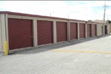
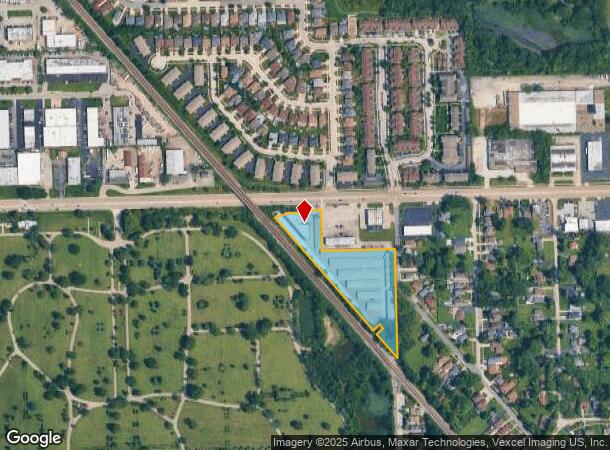
Property Record
5253 W 111Th St, Alsip, IL 60803


NEARBY LISTINGS FOR SALE OR LEASE
Property Detail
5253 W 111Th St
24-21-100-021-0000
Vps Sub
Commercialnec
Cook
X
Illinois
17031C0609J
1
2023
4.96 AC
2025
Near South Cook
823200
Chicago
137,386 SF
Chicago-Naperville-Elgin, IL-IN-WI
DEMOGRAPHICS near 5253 W 111Th St
1 Mile
3 Mile
5 Mile
2024 Total Population
13,191
143,041
365,303
2029 Population
12,840
139,319
355,244
Pop Growth 2024-2029
(2.66%)
(2.60%)
(2.75%)
Average Age
42
41
41
2024 Total Households
5,252
55,618
135,015
HH Growth 2024-2029
(2.89%)
(2.85%)
(3.01%)
Median Household Inc
$76,479
$71,865
$71,655
Avg Household Size
2.40
2.50
2.60
2024 Avg HH Vehicles
2.00
2.00
2.00
Median Home Value
$264,075
$239,848
$237,066
Median Year Built
1975
1967
1964
Nearby Places
Map Layers
Map Styles
 Street
 Aerial
- Restaurants
- Banks
- Shops
- Fitness
- Groceries
PUBLIC TRANSPORTATION
COMMUTER RAIL
Chicago Ridge Station (SouthWest Service - Northeast Illinois Regional Commuter Railroad (Metra))
DRIVE
WALK
Distance
Chicago Ridge Station (SouthWest Service - Northeast Illinois Regional Commuter Railroad (Metra))
5 min
2.4 mi
Oak Lawn Station (SouthWest Service - Northeast Illinois Regional Commuter Railroad (Metra))
DRIVE
WALK
Distance
Oak Lawn Station (SouthWest Service - Northeast Illinois Regional Commuter Railroad (Metra))
6 min
3.2 mi
AIRPORT
Chicago Midway International
DRIVE
WALK
Distance
Chicago Midway International
14 min
8.3 mi
Chicago O'Hare International
DRIVE
WALK
Distance
Chicago O'Hare International
44 min
30.9 mi
Freight Ports
Port Milwaukee
DRIVE
WALK
Distance
Port Milwaukee
125 min
102.6 mi
Nearby Properties
Address
Land Use
TOTAL SIZE
Lot Size
Zoning
Address
Land Use
TOTAL SIZE
Lot Size
Zoning
13.59 AC
MU
Address
Land Use
TOTAL SIZE
Lot Size
Zoning
Address
Land Use
TOTAL SIZE
Lot Size
Zoning
23.81 AC
Address
Land Use
TOTAL SIZE
Lot Size
Zoning
51,762 SF
4 AC
Address
Land Use
TOTAL SIZE
Lot Size
Zoning
48,792 SF
8.71 AC
RT-4
Address
Land Use
TOTAL SIZE
Lot Size
Zoning
240,300 SF
3.72 AC
Address
Land Use
TOTAL SIZE
Lot Size
Zoning
191,763 SF
15.63 AC
Address
Land Use
TOTAL SIZE
Lot Size
Zoning
495,815 SF
20.78 AC
Address
Land Use
TOTAL SIZE
Lot Size
Zoning
101,169 SF
13.07 AC
Address
Land Use
TOTAL SIZE
Lot Size
Zoning
401,021 SF
27.42 AC
Address
Land Use
TOTAL SIZE
Lot Size
Zoning
48,192 SF
2.01 AC
Address
Land Use
TOTAL SIZE
Lot Size
Zoning
61,388 SF
2 AC
Address
Land Use
TOTAL SIZE
Lot Size
Zoning
421,052 SF
26.15 AC
Address
Land Use
TOTAL SIZE
Lot Size
Zoning
510,332 SF
23.97 AC
Address
Land Use
TOTAL SIZE
Lot Size
Zoning
149,902 SF
3.62 AC
Address
Land Use
TOTAL SIZE
Lot Size
Zoning
34,970 SF
3.87 AC
Address
Land Use
TOTAL SIZE
Lot Size
Zoning
5.66 AC
Address
Land Use
TOTAL SIZE
Lot Size
Zoning
28,406 SF
1.42 AC
Address
Land Use
TOTAL SIZE
Lot Size
Zoning
36,960 SF
0.84 AC
Address
Land Use
TOTAL SIZE
Lot Size
Zoning
185,748 SF
15.30 AC
Address
Land Use
TOTAL SIZE
Lot Size
Zoning
Address
Land Use
TOTAL SIZE
Lot Size
Zoning
405,045 SF
14.49 AC
Address
Land Use
TOTAL SIZE
Lot Size
Zoning
113,963 SF
10.55 AC
Address
Land Use
TOTAL SIZE
Lot Size
Zoning
320,038 SF
13.04 AC
Address
Land Use
TOTAL SIZE
Lot Size
Zoning
869,275 SF
24.34 AC
Address
Land Use
TOTAL SIZE
Lot Size
Zoning
283,947 SF
13.27 AC
Address
Land Use
TOTAL SIZE
Lot Size
Zoning
98,506 SF
7.66 AC
Address
Land Use
TOTAL SIZE
Lot Size
Zoning
100,496 SF
9.96 AC
Address
Land Use
TOTAL SIZE
Lot Size
Zoning
171,624 SF
23.56 AC
Address
Land Use
TOTAL SIZE
Lot Size
Zoning
127,984 SF
12.76 AC
The World's #1 Commercial Real Estate Marketplace
Connect with us
© 2026 CoStar Group
The information above has been obtained from sources believed reliable. While we do not doubt its accuracy we have not verified it and make no guarantee, warranty or representation about it. It is your responsibility to independently confirm its accuracy and completeness. Any projections, opinions, assumptions, or estimates used are for example only and do not represent the current or future performance of the property. The value of this transaction to you depends on tax and other factors which should be evaluated by your tax, financial, and legal advisors. You and your advisors should conduct a careful, independent investigation of the property to determine to your satisfaction the suitability of the property for your needs.