Property Record
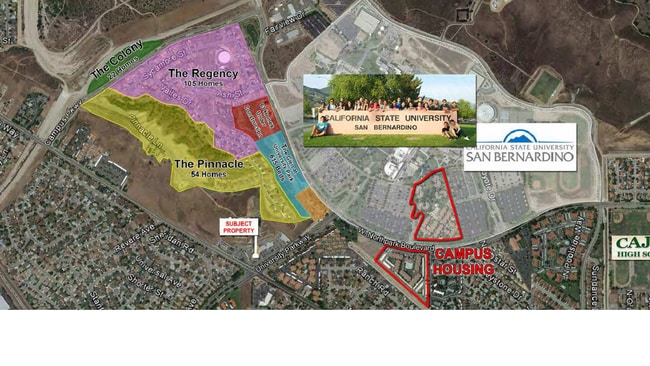
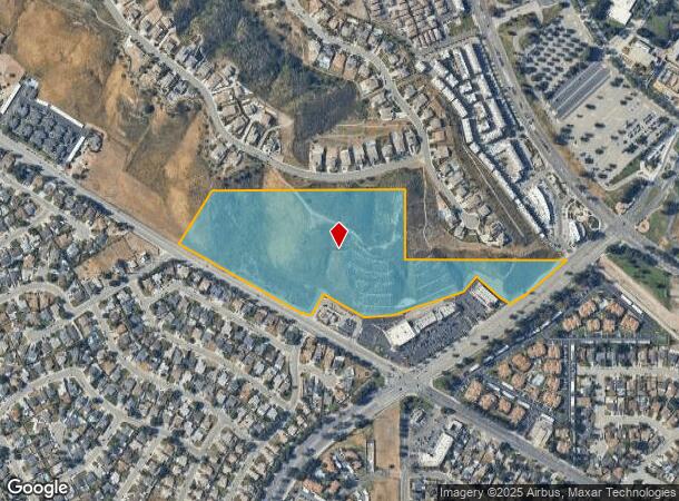
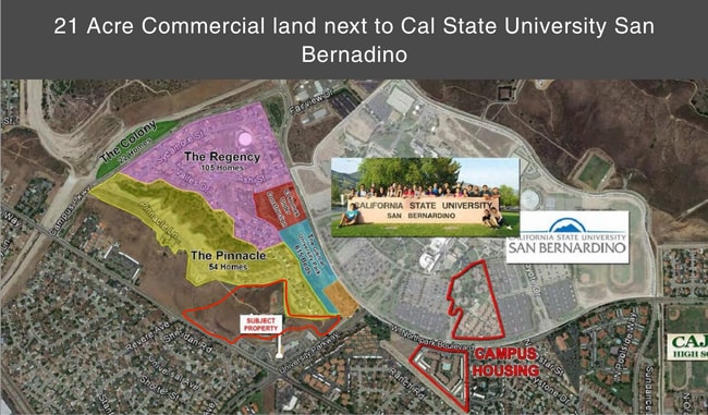
Kendall Dr, San Bernardino, CA 92407

Current Lease Availabilities
NEARBY LISTINGS FOR SALE OR LEASE
Property Detail
Kendall Dr
Riverside-San Bernardino-Ontario, CA
PTN NW 1/4 SEC 17 AND NE 1/4 SEC 18 TP 1N R 4W LYING WITHIN MUSCUPIABE RANCHO DESC AS BEG NE COR SD SEC 18 TH S 00 DEG 02 MIN 33 SECONDS E ALG ELY LI SD SEC 18 DIST 407.74 FT TH S 89 DEG 58 MIN 14 SECONDS E ALG NLY LI LOTS 1 AND 2 BLK 3 WIGGINS TR DI
0266-751-14
San Bernardino
Vacantlandnec
California
X
1,2
06071C7940J
21.38 AC
2024
San Bernardino
2025
Inland Empire (California)
004601
DEMOGRAPHICS near Kendall Dr
1 Mile
3 Mile
5 Mile
2024 Total Population
12,763
70,944
209,369
2029 Population
12,996
71,943
212,042
Pop Growth 2024-2029
+ 1.83%
+ 1.41%
+ 1.28%
Average Age
32
34
34
2024 Total Households
4,079
20,222
58,102
HH Growth 2024-2029
+ 1.77%
+ 1.41%
+ 1.24%
Median Household Inc
$73,016
$74,335
$68,589
Avg Household Size
3.00
3.40
3.50
2024 Avg HH Vehicles
2.00
2.00
2.00
Median Home Value
$377,609
$379,378
$377,327
Median Year Built
1985
1979
1968
Nearby Places
Map Layers
Map Styles
 Street
 Aerial
- Restaurants
- Banks
- Shops
- Fitness
- Groceries
PUBLIC TRANSPORTATION
COMMUTER RAIL
San Bernardino (Inland Empire-Orange County Line - Southern California Regional Rail Authority (Metrolink), San Bernardino Line - Southern California Regional Rail Authority (Metrolink))
DRIVE
WALK
Distance
San Bernardino (Inland Empire-Orange County Line - Southern California Regional Rail Authority (Metrolink), San Bernardino Line - Southern California Regional Rail Authority (Metrolink))
10 min
6.4 mi
San Bernardino - Downtown Metrolink Station (Metrolink Inland Empire-Orange County Line - Metrolink Trains, Metrolink San Bernardino Line - Metrolink Trains)
DRIVE
WALK
Distance
San Bernardino - Downtown Metrolink Station (Metrolink Inland Empire-Orange County Line - Metrolink Trains, Metrolink San Bernardino Line - Metrolink Trains)
11 min
6.8 mi
AIRPORT
Ontario International
DRIVE
WALK
Distance
Ontario International
31 min
23.5 mi
Freight Ports
Port of Long Beach
DRIVE
WALK
Distance
Port of Long Beach
91 min
72.3 mi
Nearby Properties
Address
Land Use
TOTAL SIZE
Lot Size
Zoning
Address
Land Use
TOTAL SIZE
Lot Size
Zoning
805,980 SF
39.57 AC
Address
Land Use
TOTAL SIZE
Lot Size
Zoning
830,613 SF
35.21 AC
Address
Land Use
TOTAL SIZE
Lot Size
Zoning
335,460 SF
16.45 AC
Address
Land Use
TOTAL SIZE
Lot Size
Zoning
340,057 SF
14.43 AC
Address
Land Use
TOTAL SIZE
Lot Size
Zoning
250,111 SF
12.04 AC
Address
Land Use
TOTAL SIZE
Lot Size
Zoning
843,440 SF
35.85 AC
Address
Land Use
TOTAL SIZE
Lot Size
Zoning
624,376 SF
37.65 AC
Address
Land Use
TOTAL SIZE
Lot Size
Zoning
801,377 SF
20.81 AC
Address
Land Use
TOTAL SIZE
Lot Size
Zoning
214,534 SF
17.98 AC
Address
Land Use
TOTAL SIZE
Lot Size
Zoning
127,176 SF
18.55 AC
Address
Land Use
TOTAL SIZE
Lot Size
Zoning
277,822 SF
13.65 AC
Address
Land Use
TOTAL SIZE
Lot Size
Zoning
52,258 SF
8.90 AC
Address
Land Use
TOTAL SIZE
Lot Size
Zoning
76,234 SF
24.42 AC
Address
Land Use
TOTAL SIZE
Lot Size
Zoning
392,650 SF
20.14 AC
Address
Land Use
TOTAL SIZE
Lot Size
Zoning
226,072 SF
20.42 AC
Address
Land Use
TOTAL SIZE
Lot Size
Zoning
354,108 SF
16.93 AC
Address
Land Use
TOTAL SIZE
Lot Size
Zoning
248,368 SF
19.34 AC
Address
Land Use
TOTAL SIZE
Lot Size
Zoning
326,094 SF
18.08 AC
Address
Land Use
TOTAL SIZE
Lot Size
Zoning
158,804 SF
5.63 AC
Address
Land Use
TOTAL SIZE
Lot Size
Zoning
272,408 SF
18.41 AC
Address
Land Use
TOTAL SIZE
Lot Size
Zoning
152,714 SF
9.99 AC
Address
Land Use
TOTAL SIZE
Lot Size
Zoning
254,500 SF
11.58 AC
Address
Land Use
TOTAL SIZE
Lot Size
Zoning
150,200 SF
10.08 AC
Address
Land Use
TOTAL SIZE
Lot Size
Zoning
448,460 SF
24.10 AC
Address
Land Use
TOTAL SIZE
Lot Size
Zoning
191,216 SF
10.28 AC
Address
Land Use
TOTAL SIZE
Lot Size
Zoning
103,370 SF
5.07 AC
GHSP
Address
Land Use
TOTAL SIZE
Lot Size
Zoning
137,200 SF
10.07 AC
Address
Land Use
TOTAL SIZE
Lot Size
Zoning
135,000 SF
8.62 AC
Address
Land Use
TOTAL SIZE
Lot Size
Zoning
173,958 SF
4.88 AC
Address
Land Use
TOTAL SIZE
Lot Size
Zoning
138,474 SF
10.55 AC
The World's #1 Commercial Real Estate Marketplace
Connect with us
© 2025 CoStar Group
The information above has been obtained from sources believed reliable. While we do not doubt its accuracy we have not verified it and make no guarantee, warranty or representation about it. It is your responsibility to independently confirm its accuracy and completeness. Any projections, opinions, assumptions, or estimates used are for example only and do not represent the current or future performance of the property. The value of this transaction to you depends on tax and other factors which should be evaluated by your tax, financial, and legal advisors. You and your advisors should conduct a careful, independent investigation of the property to determine to your satisfaction the suitability of the property for your needs.