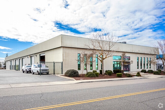
Property Record
526 Charity Way, Modesto, CA 95356


Current Lease Availabilities
NEARBY LISTINGS FOR SALE OR LEASE
Property Detail
526 Charity Way
Modesto, CA
Condominium Plan Of 502 Charity Way
004-95-10
LOT 2
Warehouse
Stanislaus
X
California
06077C0810F
2
2025
0.35 AC
2025
Outlying Stanislaus Cty
000501
Stockton/Modesto
5,000 SF
DEMOGRAPHICS near 526 Charity Way
1 mile
3 mile
5 mile
2024 Total Population
724
72,610
196,628
2029 Population
732
72,870
197,227
Pop Growth 2024-2029
+ 1.10%
+ 0.36%
+ 0.30%
Average Age
40
40
38
2024 Total Households
250
25,610
67,749
HH Growth 2024-2029
+ 1.20%
+ 0.32%
+ 0.28%
Median Household Inc
$126,531
$83,887
$80,316
Avg Household Size
2.90
2.80
2.80
2024 Avg HH Vehicles
2.00
2.00
2.00
Median Home Value
$726,923
$435,505
$413,401
Median Year Built
1994
1978
1979
Nearby Places
Map Layers
Map Styles
 Street
 Aerial
Transit
 Traffic
 Biking
Places
Listings with unknown addresses are not visible on the map
- Restaurants
- Banks
- Shops
- Fitness
- Groceries
PUBLIC TRANSPORTATION
COMMUTER RAIL
Modesto (San Joaquins - Amtrak)
Drive
Walk
Distance
Modesto (San Joaquins - Amtrak)
16 min
8.2 mi
AIRPORT
Stockton Metro
Drive
Walk
Distance
Stockton Metro
33 min
22.7 mi
Freight Ports
Port of Stockton
Drive
Walk
Distance
Port of Stockton
42 min
31.1 mi
Nearby Properties
Address
Land Use
TOTAL SIZE
Lot Size
Zoning
Address
Land Use
TOTAL SIZE
Lot Size
Zoning
640,835 SF
47.18 AC
PC
Address
Land Use
TOTAL SIZE
Lot Size
Zoning
9.25 AC
MODSP
Address
Land Use
TOTAL SIZE
Lot Size
Zoning
20.31 AC
COUPD
Address
Land Use
TOTAL SIZE
Lot Size
Zoning
189,239 SF
8.75 AC
PD
Address
Land Use
TOTAL SIZE
Lot Size
Zoning
131,958 SF
8.11 AC
Address
Land Use
TOTAL SIZE
Lot Size
Zoning
127,142 SF
3.89 AC
MODSP
Address
Land Use
TOTAL SIZE
Lot Size
Zoning
156,854 SF
12.20 AC
PC
Address
Land Use
TOTAL SIZE
Lot Size
Zoning
15.68 AC
RIVPD
Address
Land Use
TOTAL SIZE
Lot Size
Zoning
164,473 SF
3.50 AC
MODSP
Address
Land Use
TOTAL SIZE
Lot Size
Zoning
120,160 SF
6 AC
MODPD
Address
Land Use
TOTAL SIZE
Lot Size
Zoning
110,684 SF
5.03 AC
Address
Land Use
TOTAL SIZE
Lot Size
Zoning
123,575 SF
10 AC
PC
Address
Land Use
TOTAL SIZE
Lot Size
Zoning
119,046 SF
8.94 AC
Address
Land Use
TOTAL SIZE
Lot Size
Zoning
60,156 SF
16.20 AC
Address
Land Use
TOTAL SIZE
Lot Size
Zoning
45,916 SF
4.69 AC
MODPO
Address
Land Use
TOTAL SIZE
Lot Size
Zoning
72,338 SF
5.98 AC
RIVC1
Address
Land Use
TOTAL SIZE
Lot Size
Zoning
188,676 SF
13.27 AC
Address
Land Use
TOTAL SIZE
Lot Size
Zoning
88,224 SF
5.13 AC
PD
Address
Land Use
TOTAL SIZE
Lot Size
Zoning
80,987 SF
4.33 AC
PD
Address
Land Use
TOTAL SIZE
Lot Size
Zoning
137,582 SF
19.21 AC
MODSP
Address
Land Use
TOTAL SIZE
Lot Size
Zoning
92,351 SF
3.85 AC
Address
Land Use
TOTAL SIZE
Lot Size
Zoning
70,352 SF
17.49 AC
MODSP
Address
Land Use
TOTAL SIZE
Lot Size
Zoning
157,353 SF
9 AC
Address
Land Use
TOTAL SIZE
Lot Size
Zoning
75,922 SF
3.93 AC
Address
Land Use
TOTAL SIZE
Lot Size
Zoning
140,669 SF
10.96 AC
PC
Address
Land Use
TOTAL SIZE
Lot Size
Zoning
47,760 SF
128 AC
Address
Land Use
TOTAL SIZE
Lot Size
Zoning
79,599 SF
5.04 AC
Address
Land Use
TOTAL SIZE
Lot Size
Zoning
56,265 SF
4.94 AC
MODPD
Address
Land Use
TOTAL SIZE
Lot Size
Zoning
71,877 SF
2 AC
MODSP
Address
Land Use
TOTAL SIZE
Lot Size
Zoning
66,350 SF
9.16 AC
The World's #1 Commercial Real Estate Marketplace
Connect with us
© 2026 CoStar Group
The information above has been obtained from sources believed reliable. While we do not doubt its accuracy we have not verified it and make no guarantee, warranty or representation about it. It is your responsibility to independently confirm its accuracy and completeness. Any projections, opinions, assumptions, or estimates used are for example only and do not represent the current or future performance of the property. The value of this transaction to you depends on tax and other factors which should be evaluated by your tax, financial, and legal advisors. You and your advisors should conduct a careful, independent investigation of the property to determine to your satisfaction the suitability of the property for your needs.