Property Record
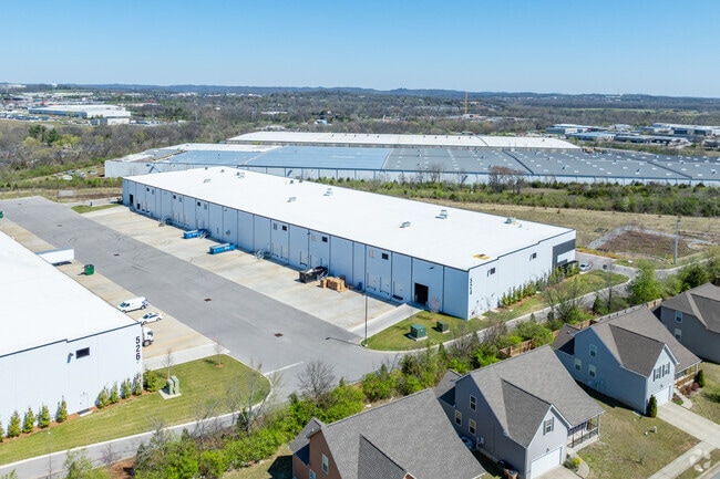
526 Myatt Dr, Madison, TN 37115


Property Detail
526 Myatt Dr
034-00-0-050
TRACT 1 OZBURN-HESSEY STORAGE CO., INC.CONSOLIDATION PLAT
Publicstorage
Davidson
IR
Tennessee
B and X Area of moderate flood hazard, usually the area between the limits of the 100-year and 500-year floods.
16.44 AC
2025
North
2025
Nashville
010401
Nashville-Davidson--Murfreesboro--Franklin, TN
93,000 SF
NEARBY LISTINGS FOR SALE OR LEASE
DEMOGRAPHICS near 526 Myatt Dr
1 mile
3 mile
5 mile
2025 Total Population
7,110
48,955
116,076
2030 Population
7,321
50,881
121,229
Pop Growth 2025-2030
+ 2.97%
+ 3.93%
+ 4.44%
Average Age
39
39
40
2025 Total Households
3,039
21,121
48,629
HH Growth 2025-2030
+ 3.22%
+ 4.31%
+ 4.80%
Median Household Inc
$48,689
$59,779
$71,069
Avg Household Size
2.30
2.30
2.30
2025 Avg HH Vehicles
2.00
2.00
2.00
Median Home Value
$252,199
$298,903
$363,999
Median Year Built
1975
1983
1983
Nearby Places
Map Layers
Map Styles
 Street
 Aerial
Layers
 Traffic
 Biking
Places
Listings with unknown addresses are not visible on the map
- Restaurants
- Banks
- Shops
- Fitness
- Groceries
PUBLIC TRANSPORTATION
AIRPORT
Nashville International
Drive
Walk
Distance
Nashville International
27 min
16.0 mi
Freight Ports
Port of Mobile
Drive
Walk
Distance
Port of Mobile
501 min
456.6 mi
SALE & LEASE HISTORY
LISTING DATE
SALE/LEASE

Jun 08, 2021
For Lease
Nearby Properties
Address
Land Use
TOTAL SIZE
Lot Size
Zoning
Address
Land Use
TOTAL SIZE
Lot Size
Zoning
26,434 SF
12.86 AC
RM20
Address
Land Use
TOTAL SIZE
Lot Size
Zoning
102,738 SF
6.25 AC
MULTIZONE
Address
Land Use
TOTAL SIZE
Lot Size
Zoning
11,088 SF
21.28 AC
RS7.5
Address
Land Use
TOTAL SIZE
Lot Size
Zoning
17,292 SF
12.35 AC
RM20
Address
Land Use
TOTAL SIZE
Lot Size
Zoning
30,534 SF
19.77 AC
SP
Address
Land Use
TOTAL SIZE
Lot Size
Zoning
102,431 SF
19.59 AC
6ZZ
Address
Land Use
TOTAL SIZE
Lot Size
Zoning
336,784 SF
41.54 AC
IR
Address
Land Use
TOTAL SIZE
Lot Size
Zoning
16,770 SF
76.79 AC
RM4
Address
Land Use
TOTAL SIZE
Lot Size
Zoning
17,214 SF
40.52 AC
RM9
Address
Land Use
TOTAL SIZE
Lot Size
Zoning
169,292 SF
12 AC
RM20
Address
Land Use
TOTAL SIZE
Lot Size
Zoning
6,120 SF
17.46 AC
R10
Address
Land Use
TOTAL SIZE
Lot Size
Zoning
25,212 SF
31.56 AC
Address
Land Use
TOTAL SIZE
Lot Size
Zoning
162,261 SF
6.20 AC
RM40
Address
Land Use
TOTAL SIZE
Lot Size
Zoning
31,528 SF
17.61 AC
6ZZ
Address
Land Use
TOTAL SIZE
Lot Size
Zoning
72,951 SF
5.31 AC
6ZZ
Address
Land Use
TOTAL SIZE
Lot Size
Zoning
3,993 SF
21.86 AC
6ZZ
Address
Land Use
TOTAL SIZE
Lot Size
Zoning
13,950 SF
17.60 AC
R8
Address
Land Use
TOTAL SIZE
Lot Size
Zoning
42,840 SF
21.43 AC
CS
Address
Land Use
TOTAL SIZE
Lot Size
Zoning
3,312 SF
33.03 AC
IR
Address
Land Use
TOTAL SIZE
Lot Size
Zoning
12,576 SF
16.09 AC
6ZZ
Address
Land Use
TOTAL SIZE
Lot Size
Zoning
191,733 SF
62.90 AC
MULTI-ZONE
Address
Land Use
TOTAL SIZE
Lot Size
Zoning
146,323 SF
4.48 AC
RM40
Address
Land Use
TOTAL SIZE
Lot Size
Zoning
34,752 SF
19.09 AC
CS
Address
Land Use
TOTAL SIZE
Lot Size
Zoning
112,056 SF
40.15 AC
MULTIZONE
Address
Land Use
TOTAL SIZE
Lot Size
Zoning
26,610 SF
6.66 AC
RS20
Address
Land Use
TOTAL SIZE
Lot Size
Zoning
3,864 SF
4.05 AC
RS5
Address
Land Use
TOTAL SIZE
Lot Size
Zoning
21,356 SF
11.25 AC
6ZZ
Address
Land Use
TOTAL SIZE
Lot Size
Zoning
28,000 SF
38.86 AC
6ZZ
Address
Land Use
TOTAL SIZE
Lot Size
Zoning
10,312 SF
15.03 AC
6ZZ
The World's #1 Commercial Real Estate Marketplace
Connect with us
© 2026 CoStar Group
The information above has been obtained from sources believed reliable. While we do not doubt its accuracy we have not verified it and make no guarantee, warranty or representation about it. It is your responsibility to independently confirm its accuracy and completeness. Any projections, opinions, assumptions, or estimates used are for example only and do not represent the current or future performance of the property. The value of this transaction to you depends on tax and other factors which should be evaluated by your tax, financial, and legal advisors. You and your advisors should conduct a careful, independent investigation of the property to determine to your satisfaction the suitability of the property for your needs.