Property Record
526 Three Sisters Rd, Knightdale, NC 27545
Current Lease Availabilities
NEARBY LISTINGS FOR SALE OR LEASE
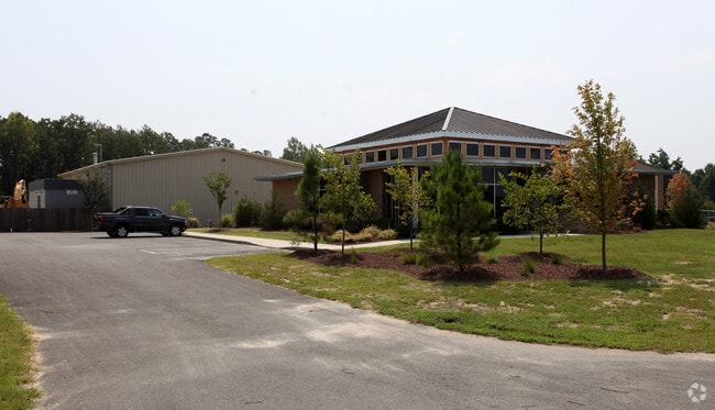
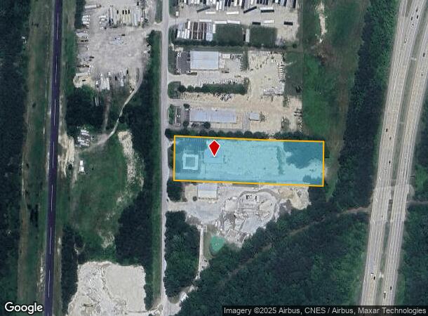
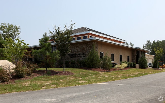
Property Detail
526 Three Sisters Rd
Raleigh, NC
Thompson Industrial Park
1764.02-75-8644-000
LO10 THOMPSON INDUSTRIAL PARK BM1999-102
Officebuilding
Wake
X
North Carolina
3720176400K
10
0
3.12 AC
2025
Northeast Wake County
054404
Raleigh/Durham
8,714 SF
DEMOGRAPHICS near 526 Three Sisters Rd
1 Mile
3 Mile
5 Mile
2024 Total Population
202
21,359
56,876
2029 Population
222
23,717
62,371
Pop Growth 2024-2029
+ 9.90%
+ 11.04%
+ 9.66%
Average Age
40
38
38
2024 Total Households
74
7,798
20,901
HH Growth 2024-2029
+ 9.46%
+ 11.12%
+ 9.72%
Median Household Inc
$80,357
$80,803
$76,392
Avg Household Size
2.70
2.70
2.70
2024 Avg HH Vehicles
2.00
2.00
2.00
Median Home Value
$315,000
$298,980
$275,049
Median Year Built
1988
2002
1999
Nearby Places
- Restaurants
- Banks
- Shops
- Fitness
- Groceries
PUBLIC TRANSPORTATION
AIRPORT
Raleigh-Durham International
DRIVE
WALK
Distance
Raleigh-Durham International
38 min
26.9 mi
Freight Ports
Port of Wilmington
DRIVE
WALK
Distance
Port of Wilmington
164 min
142.1 mi
Nearby Properties
Address
Land Use
TOTAL SIZE
Lot Size
Zoning
Address
Land Use
TOTAL SIZE
Lot Size
Zoning
377,673 SF
27.54 AC
PUD-1
Address
Land Use
TOTAL SIZE
Lot Size
Zoning
176,286 SF
103.50 AC
CMX
Address
Land Use
TOTAL SIZE
Lot Size
Zoning
392,729 SF
72.10 AC
CU-O&
Address
Land Use
TOTAL SIZE
Lot Size
Zoning
301,933 SF
12.92 AC
PUD-1
Address
Land Use
TOTAL SIZE
Lot Size
Zoning
328,918 SF
17.24 AC
CMX-C
Address
Land Use
TOTAL SIZE
Lot Size
Zoning
263,074 SF
83.23 AC
GR8
Address
Land Use
TOTAL SIZE
Lot Size
Zoning
209,019 SF
5 AC
NMX P
Address
Land Use
TOTAL SIZE
Lot Size
Zoning
356,188 SF
31.21 AC
MI-CD
Address
Land Use
TOTAL SIZE
Lot Size
Zoning
222,108 SF
21.81 AC
UR12
Address
Land Use
TOTAL SIZE
Lot Size
Zoning
299,965 SF
16.34 AC
RMX
Address
Land Use
TOTAL SIZE
Lot Size
Zoning
411,764 SF
59.16 AC
MI
Address
Land Use
TOTAL SIZE
Lot Size
Zoning
152,472 SF
24.42 AC
R-40
Address
Land Use
TOTAL SIZE
Lot Size
Zoning
81,915 SF
18.72 AC
CH
Address
Land Use
TOTAL SIZE
Lot Size
Zoning
61,750 SF
12.01 AC
PUD-1
Address
Land Use
TOTAL SIZE
Lot Size
Zoning
105,512 SF
17.63 AC
R3
Address
Land Use
TOTAL SIZE
Lot Size
Zoning
63,414 SF
95.15 AC
RT
Address
Land Use
TOTAL SIZE
Lot Size
Zoning
103,924 SF
16.92 AC
GR8
Address
Land Use
TOTAL SIZE
Lot Size
Zoning
271,950 SF
128.61 AC
I-2
Address
Land Use
TOTAL SIZE
Lot Size
Zoning
66,695 SF
19.89 AC
NC
Address
Land Use
TOTAL SIZE
Lot Size
Zoning
86,168 SF
19.65 AC
RA
Address
Land Use
TOTAL SIZE
Lot Size
Zoning
41,572 SF
43.57 AC
CMX-C
Address
Land Use
TOTAL SIZE
Lot Size
Zoning
89,350 SF
21.48 AC
UR12
Address
Land Use
TOTAL SIZE
Lot Size
Zoning
201.30 AC
MI
Address
Land Use
TOTAL SIZE
Lot Size
Zoning
87,578 SF
16.29 AC
RMX
Address
Land Use
TOTAL SIZE
Lot Size
Zoning
24,519 SF
10.79 AC
PUD-1
Address
Land Use
TOTAL SIZE
Lot Size
Zoning
35,968 SF
11.97 AC
NMX
Address
Land Use
TOTAL SIZE
Lot Size
Zoning
867 SF
66.88 AC
NMX
Address
Land Use
TOTAL SIZE
Lot Size
Zoning
135,599 SF
15.56 AC
HB
Address
Land Use
TOTAL SIZE
Lot Size
Zoning
56,052 SF
31.08 AC
RT
Address
Land Use
TOTAL SIZE
Lot Size
Zoning
138,653 SF
45.85 AC
MI
The World's #1 Commercial Real Estate Marketplace
Connect with us
© 2025 CoStar Group
The information above has been obtained from sources believed reliable. While we do not doubt its accuracy we have not verified it and make no guarantee, warranty or representation about it. It is your responsibility to independently confirm its accuracy and completeness. Any projections, opinions, assumptions, or estimates used are for example only and do not represent the current or future performance of the property. The value of this transaction to you depends on tax and other factors which should be evaluated by your tax, financial, and legal advisors. You and your advisors should conduct a careful, independent investigation of the property to determine to your satisfaction the suitability of the property for your needs.