Property Record
5266 Highway 71 E, Del Valle, TX 78617
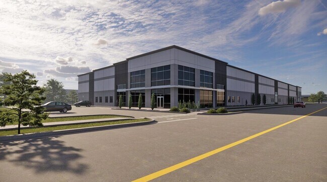

This Property Is For Sale
Current Lease Availabilities
Property Detail
5266 Highway 71 E
296012
ABS 18 NAVARRO J A ACR 86.0550
Farms
TRAVIS
AE The base floodplain where base flood elevations are provided. AE Zones are now used on new format FIRMs instead of A1-A30 Zones.
Texas
2025
86.06 AC
2025
Southeast
002453
Austin
3,192 SF
Austin-Round Rock-San Marcos, TX
NEARBY LISTINGS FOR SALE OR LEASE
DEMOGRAPHICS near 5266 Highway 71 E
1 mile
3 mile
5 mile
2025 Total Population
229
2,917
27,291
2030 Population
240
3,116
29,246
Pop Growth 2025-2030
+ 4.80%
+ 6.82%
+ 7.16%
Average Age
38
39
36
2025 Total Households
69
956
8,345
HH Growth 2025-2030
+ 5.80%
+ 7.64%
+ 7.84%
Median Household Inc
$72,856
$83,223
$89,818
Avg Household Size
3.10
2.90
3.20
2025 Avg HH Vehicles
2.00
2.00
2.00
Median Home Value
$81,481
$199,999
$317,331
Median Year Built
1984
1990
2008
Nearby Places
Map Layers
Map Styles
 Street
 Aerial
Transit
 Traffic
 Biking
Places
Listings with unknown addresses are not visible on the map
- Restaurants
- Banks
- Shops
- Fitness
- Groceries
PUBLIC TRANSPORTATION
AIRPORT
Austin-Bergstrom International
Drive
Walk
Distance
Austin-Bergstrom International
21 min
11.5 mi
Freight Ports
Calhoun Port
Drive
Walk
Distance
Calhoun Port
182 min
154.5 mi
Nearby Properties
Address
Land Use
TOTAL SIZE
Lot Size
Zoning
Address
Land Use
TOTAL SIZE
Lot Size
Zoning
1 SF
120 AC
Address
Land Use
TOTAL SIZE
Lot Size
Zoning
215,912 SF
40.94 AC
Address
Land Use
TOTAL SIZE
Lot Size
Zoning
550 SF
31.23 AC
Address
Land Use
TOTAL SIZE
Lot Size
Zoning
1.44 AC
Address
Land Use
TOTAL SIZE
Lot Size
Zoning
90,251 SF
12.48 AC
Address
Land Use
TOTAL SIZE
Lot Size
Zoning
238.94 AC
Address
Land Use
TOTAL SIZE
Lot Size
Zoning
18,248 SF
36.47 AC
Address
Land Use
TOTAL SIZE
Lot Size
Zoning
784 SF
316.76 AC
Address
Land Use
TOTAL SIZE
Lot Size
Zoning
7,653 SF
36.99 AC
Address
Land Use
TOTAL SIZE
Lot Size
Zoning
43.26 AC
Address
Land Use
TOTAL SIZE
Lot Size
Zoning
19,968 SF
0.58 AC
Address
Land Use
TOTAL SIZE
Lot Size
Zoning
48,254 SF
9.42 AC
Address
Land Use
TOTAL SIZE
Lot Size
Zoning
6,633 SF
18.82 AC
Address
Land Use
TOTAL SIZE
Lot Size
Zoning
139.67 AC
Address
Land Use
TOTAL SIZE
Lot Size
Zoning
113.55 AC
Address
Land Use
TOTAL SIZE
Lot Size
Zoning
54,640 SF
6.40 AC
Address
Land Use
TOTAL SIZE
Lot Size
Zoning
104.29 AC
Address
Land Use
TOTAL SIZE
Lot Size
Zoning
900 SF
425.40 AC
Address
Land Use
TOTAL SIZE
Lot Size
Zoning
119.06 AC
Address
Land Use
TOTAL SIZE
Lot Size
Zoning
10,232 SF
278.51 AC
Address
Land Use
TOTAL SIZE
Lot Size
Zoning
10,420 SF
3.73 AC
Address
Land Use
TOTAL SIZE
Lot Size
Zoning
Address
Land Use
TOTAL SIZE
Lot Size
Zoning
12,454 SF
2 AC
Address
Land Use
TOTAL SIZE
Lot Size
Zoning
61.48 AC
Address
Land Use
TOTAL SIZE
Lot Size
Zoning
1,823 SF
55.07 AC
Address
Land Use
TOTAL SIZE
Lot Size
Zoning
9,980 SF
10.77 AC
Address
Land Use
TOTAL SIZE
Lot Size
Zoning
179.17 AC
Address
Land Use
TOTAL SIZE
Lot Size
Zoning
39.40 AC
The World's #1 Commercial Real Estate Marketplace
Connect with us
© 2026 CoStar Group
The information above has been obtained from sources believed reliable. While we do not doubt its accuracy we have not verified it and make no guarantee, warranty or representation about it. It is your responsibility to independently confirm its accuracy and completeness. Any projections, opinions, assumptions, or estimates used are for example only and do not represent the current or future performance of the property. The value of this transaction to you depends on tax and other factors which should be evaluated by your tax, financial, and legal advisors. You and your advisors should conduct a careful, independent investigation of the property to determine to your satisfaction the suitability of the property for your needs.