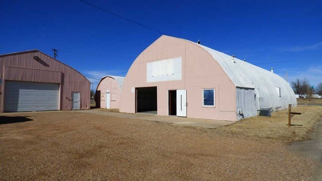
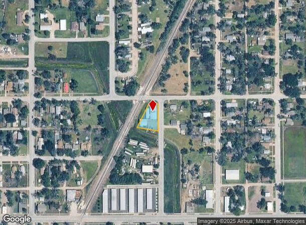
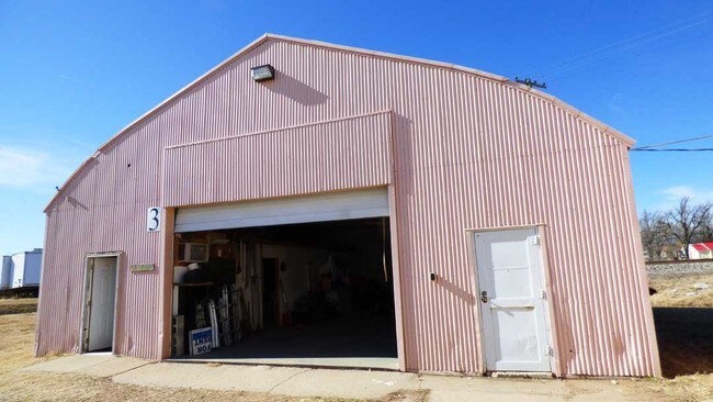
Property Record
527 Fontron St, Hutchinson, KS 67501
NEARBY LISTINGS FOR SALE OR LEASE
Property Detail
527 Fontron St
Hutchinson, KS
Montrose
133-08-0-30-20-001.00
MONTROSE, S08, T23, R05W, PT LOT 28 BEG NE COR LOT 28 S 25 FT NWLY TO NW COR LOT 28 E TO POB AND LOTS 29-34 BLK 1
Warehouse
Reno
X
Kansas
20155C0292G
28
2024
0.34 AC
2024
Kansas Area
001000
Other Market Areas
1,680 SF
DEMOGRAPHICS near 527 Fontron St
1 Mile
3 Mile
5 Mile
2024 Total Population
4,777
33,750
45,215
2029 Population
4,812
33,722
45,043
Pop Growth 2024-2029
+ 0.73%
(0.08%)
(0.38%)
Average Age
39
40
42
2024 Total Households
2,082
14,410
19,149
HH Growth 2024-2029
+ 0.67%
(0.11%)
(0.42%)
Median Household Inc
$39,018
$48,188
$51,755
Avg Household Size
2.20
2.20
2.20
2024 Avg HH Vehicles
2.00
2.00
2.00
Median Home Value
$56,334
$93,868
$114,273
Median Year Built
1958
1957
1960
Nearby Places
Map Layers
Map Styles
 Street
 Aerial
- Restaurants
- Banks
- Shops
- Fitness
- Groceries
PUBLIC TRANSPORTATION
COMMUTER RAIL
Hutchinson Amtrak Station (Southwest Chief - Amtrak)
DRIVE
WALK
Distance
Hutchinson Amtrak Station (Southwest Chief - Amtrak)
5 min
2.2 mi
Freight Ports
Tulsa Port Of Catoosa
DRIVE
WALK
Distance
Tulsa Port Of Catoosa
263 min
241.4 mi
SALE & LEASE HISTORY
LISTING DATE
SALE/LEASE

Feb 17, 2017
For Sale
Nearby Properties
Address
Land Use
TOTAL SIZE
Lot Size
Zoning
Address
Land Use
TOTAL SIZE
Lot Size
Zoning
19,260 SF
11 AC
P
Address
Land Use
TOTAL SIZE
Lot Size
Zoning
94,825 SF
10 AC
Address
Land Use
TOTAL SIZE
Lot Size
Zoning
89,458 SF
1.88 AC
P
Address
Land Use
TOTAL SIZE
Lot Size
Zoning
2,502 SF
44.42 AC
P
Address
Land Use
TOTAL SIZE
Lot Size
Zoning
3,120 SF
36.34 AC
PI
Address
Land Use
TOTAL SIZE
Lot Size
Zoning
2,400 SF
18 AC
Address
Land Use
TOTAL SIZE
Lot Size
Zoning
1,728 SF
10.68 AC
P
Address
Land Use
TOTAL SIZE
Lot Size
Zoning
59.65 AC
P
Address
Land Use
TOTAL SIZE
Lot Size
Zoning
54,149 SF
9.27 AC
Address
Land Use
TOTAL SIZE
Lot Size
Zoning
42,659 SF
4.58 AC
P
Address
Land Use
TOTAL SIZE
Lot Size
Zoning
579 SF
629.53 AC
Address
Land Use
TOTAL SIZE
Lot Size
Zoning
12,896 SF
102.35 AC
I3
Address
Land Use
TOTAL SIZE
Lot Size
Zoning
121,446 SF
14.69 AC
PI
Address
Land Use
TOTAL SIZE
Lot Size
Zoning
143 SF
110.23 AC
P
Address
Land Use
TOTAL SIZE
Lot Size
Zoning
2,400 SF
25.83 AC
Address
Land Use
TOTAL SIZE
Lot Size
Zoning
4,000 SF
19.83 AC
C1
Address
Land Use
TOTAL SIZE
Lot Size
Zoning
64,700 SF
5.73 AC
C4
Address
Land Use
TOTAL SIZE
Lot Size
Zoning
29,431 SF
1.50 AC
C5
Address
Land Use
TOTAL SIZE
Lot Size
Zoning
64,802 SF
14.07 AC
P
Address
Land Use
TOTAL SIZE
Lot Size
Zoning
43,928 SF
4.99 AC
R5
Address
Land Use
TOTAL SIZE
Lot Size
Zoning
1,320 SF
5.94 AC
Address
Land Use
TOTAL SIZE
Lot Size
Zoning
7,200 SF
35.24 AC
Address
Land Use
TOTAL SIZE
Lot Size
Zoning
3,648 SF
15.60 AC
CR
Address
Land Use
TOTAL SIZE
Lot Size
Zoning
101,932 SF
1.50 AC
P
Address
Land Use
TOTAL SIZE
Lot Size
Zoning
89,591 SF
3.31 AC
P
Address
Land Use
TOTAL SIZE
Lot Size
Zoning
840 SF
17.62 AC
P
Address
Land Use
TOTAL SIZE
Lot Size
Zoning
3,064 SF
3.46 AC
Address
Land Use
TOTAL SIZE
Lot Size
Zoning
3,240 SF
13.17 AC
P
Address
Land Use
TOTAL SIZE
Lot Size
Zoning
59,962 SF
2.52 AC
P
Address
Land Use
TOTAL SIZE
Lot Size
Zoning
16,116 SF
1.37 AC
C1
The World's #1 Commercial Real Estate Marketplace
Connect with us
© 2025 CoStar Group
The information above has been obtained from sources believed reliable. While we do not doubt its accuracy we have not verified it and make no guarantee, warranty or representation about it. It is your responsibility to independently confirm its accuracy and completeness. Any projections, opinions, assumptions, or estimates used are for example only and do not represent the current or future performance of the property. The value of this transaction to you depends on tax and other factors which should be evaluated by your tax, financial, and legal advisors. You and your advisors should conduct a careful, independent investigation of the property to determine to your satisfaction the suitability of the property for your needs.