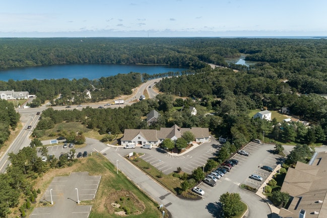
Property Record
527 Long Pond Dr, Harwich, MA 02645

NEARBY LISTINGS FOR SALE OR LEASE
-
-
View all Harwich listings for lease on LoopNet.com
Property Detail
527 Long Pond Dr
Medicalbuilding
Barnstable
X
Massachusetts
25001C0606J
1.19 AC
2025
Cape Cod
2025
Other Market Areas
011100
Barnstable Town, MA
8,990 SF
HARW-000111-000000-A000002
DEMOGRAPHICS near 527 Long Pond Dr
1 Mile
3 Mile
5 Mile
2024 Total Population
1,419
15,096
35,358
2029 Population
1,454
15,633
37,005
Pop Growth 2024-2029
+ 2.47%
+ 3.56%
+ 4.66%
Average Age
49
51
53
2024 Total Households
584
6,853
16,661
HH Growth 2024-2029
+ 2.23%
+ 3.46%
+ 4.66%
Median Household Inc
$91,071
$88,991
$87,899
Avg Household Size
2.30
2.10
2.00
2024 Avg HH Vehicles
2.00
2.00
2.00
Median Home Value
$648,368
$601,485
$656,505
Median Year Built
1979
1980
1978
Nearby Places
Map Layers
Map Styles
 Street
 Aerial
- Restaurants
- Banks
- Shops
- Fitness
- Groceries
SALE & LEASE HISTORY
LISTING DATE
SALE/LEASE

Nov 16, 2018
For Lease
Nearby Properties
Address
Land Use
TOTAL SIZE
Lot Size
Zoning
Address
Land Use
TOTAL SIZE
Lot Size
Zoning
49.58 AC
E
Address
Land Use
TOTAL SIZE
Lot Size
Zoning
10,884 SF
22.18 AC
R
Address
Land Use
TOTAL SIZE
Lot Size
Zoning
108,575 SF
0.48 AC
RESD.
Address
Land Use
TOTAL SIZE
Lot Size
Zoning
129.50 AC
R40
Address
Land Use
TOTAL SIZE
Lot Size
Zoning
18.12 AC
R
Address
Land Use
TOTAL SIZE
Lot Size
Zoning
184.82 AC
E
Address
Land Use
TOTAL SIZE
Lot Size
Zoning
12.93 AC
R
Address
Land Use
TOTAL SIZE
Lot Size
Zoning
83,860 SF
9.96 AC
RESD.
Address
Land Use
TOTAL SIZE
Lot Size
Zoning
3,200 SF
142.32 AC
E
Address
Land Use
TOTAL SIZE
Lot Size
Zoning
65,651 SF
13.03 AC
RESD.
Address
Land Use
TOTAL SIZE
Lot Size
Zoning
70,653 SF
12.61 AC
RESD.
Address
Land Use
TOTAL SIZE
Lot Size
Zoning
10.19 AC
R30
Address
Land Use
TOTAL SIZE
Lot Size
Zoning
5,412 SF
128.90 AC
RESD.
Address
Land Use
TOTAL SIZE
Lot Size
Zoning
93,832 SF
22.68 AC
COMM H
Address
Land Use
TOTAL SIZE
Lot Size
Zoning
153.96 AC
E
Address
Land Use
TOTAL SIZE
Lot Size
Zoning
2,492 SF
167.50 AC
RESD.
Address
Land Use
TOTAL SIZE
Lot Size
Zoning
9,540 SF
51.23 AC
Address
Land Use
TOTAL SIZE
Lot Size
Zoning
11,952 SF
26.20 AC
RESD.
Address
Land Use
TOTAL SIZE
Lot Size
Zoning
Address
Land Use
TOTAL SIZE
Lot Size
Zoning
5,933 SF
1.90 AC
R
Address
Land Use
TOTAL SIZE
Lot Size
Zoning
5,342 SF
2.50 AC
R
Address
Land Use
TOTAL SIZE
Lot Size
Zoning
53,410 SF
5.85 AC
E
Address
Land Use
TOTAL SIZE
Lot Size
Zoning
46,579 SF
4.58 AC
R
Address
Land Use
TOTAL SIZE
Lot Size
Zoning
3.61 AC
R
Address
Land Use
TOTAL SIZE
Lot Size
Zoning
2,512 SF
6.55 AC
RESD.
Address
Land Use
TOTAL SIZE
Lot Size
Zoning
16,080 SF
66.16 AC
RESD.
Address
Land Use
TOTAL SIZE
Lot Size
Zoning
8,416 SF
6.56 AC
R60
Address
Land Use
TOTAL SIZE
Lot Size
Zoning
11.91 AC
E
Address
Land Use
TOTAL SIZE
Lot Size
Zoning
12,778 SF
14.40 AC
COMM H
Address
Land Use
TOTAL SIZE
Lot Size
Zoning
The World's #1 Commercial Real Estate Marketplace
Connect with us
© 2025 CoStar Group
The information above has been obtained from sources believed reliable. While we do not doubt its accuracy we have not verified it and make no guarantee, warranty or representation about it. It is your responsibility to independently confirm its accuracy and completeness. Any projections, opinions, assumptions, or estimates used are for example only and do not represent the current or future performance of the property. The value of this transaction to you depends on tax and other factors which should be evaluated by your tax, financial, and legal advisors. You and your advisors should conduct a careful, independent investigation of the property to determine to your satisfaction the suitability of the property for your needs.