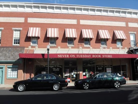
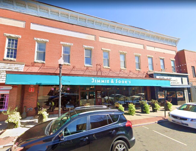
Property Record
527 Poplar St, Cambridge, MD 21613


Current Lease Availabilities
Property Detail
527 Poplar St
07-113315
LOT 10,315 SQ FT 527-529-531 POPLAR STREE CAMBRIDGE
Restaurantbuilding
Dorchester
C-2
Maryland
B and X Area of moderate flood hazard, usually the area between the limits of the 100-year and 500-year floods.
0.24 AC
2025
Chesapeake Bay/Salisbury
2025
Other Market Areas
970400
Cambridge, MD
10,100 SF
NEARBY LISTINGS FOR SALE OR LEASE
DEMOGRAPHICS near 527 Poplar St
1 mile
3 mile
5 mile
2025 Total Population
9,727
16,220
18,075
2030 Population
10,077
16,731
18,620
Pop Growth 2025-2030
+ 3.60%
+ 3.15%
+ 3.02%
Average Age
41
42
42
2025 Total Households
4,241
6,944
7,715
HH Growth 2025-2030
+ 3.56%
+ 3.07%
+ 2.93%
Median Household Inc
$46,507
$50,536
$53,484
Avg Household Size
2.20
2.30
2.30
2025 Avg HH Vehicles
1.00
2.00
2.00
Median Home Value
$268,469
$269,999
$284,618
Median Year Built
1968
1971
1972
Nearby Places
Map Layers
Map Styles
 Street
 Aerial
Layers
 Traffic
 Biking
Places
Listings with unknown addresses are not visible on the map
- Restaurants
- Banks
- Shops
- Fitness
- Groceries
Nearby Properties
Address
Land Use
TOTAL SIZE
Lot Size
Zoning
Address
Land Use
TOTAL SIZE
Lot Size
Zoning
362,536 SF
35.35 AC
MR
Address
Land Use
TOTAL SIZE
Lot Size
Zoning
189,050 SF
126 AC
R-1
Address
Land Use
TOTAL SIZE
Lot Size
Zoning
83,112 SF
4.73 AC
C-2
Address
Land Use
TOTAL SIZE
Lot Size
Zoning
45,900 SF
92.08 AC
R-1
Address
Land Use
TOTAL SIZE
Lot Size
Zoning
115,450 SF
22 AC
R1
Address
Land Use
TOTAL SIZE
Lot Size
Zoning
67,000 SF
15 AC
I-2
Address
Land Use
TOTAL SIZE
Lot Size
Zoning
31,070 SF
9.03 AC
R
Address
Land Use
TOTAL SIZE
Lot Size
Zoning
2,548 SF
17.40 AC
R-3
Address
Land Use
TOTAL SIZE
Lot Size
Zoning
150,397 SF
13.47 AC
C-2
Address
Land Use
TOTAL SIZE
Lot Size
Zoning
43,206 SF
30.77 AC
INST
Address
Land Use
TOTAL SIZE
Lot Size
Zoning
7,204 SF
207.24 AC
MR
Address
Land Use
TOTAL SIZE
Lot Size
Zoning
219,293 SF
33.66 AC
I-1
Address
Land Use
TOTAL SIZE
Lot Size
Zoning
70,000 SF
1.61 AC
Address
Land Use
TOTAL SIZE
Lot Size
Zoning
62,913 SF
4.34 AC
Address
Land Use
TOTAL SIZE
Lot Size
Zoning
61,714 SF
1.94 AC
I-2
Address
Land Use
TOTAL SIZE
Lot Size
Zoning
24,201 SF
4.09 AC
C-2
Address
Land Use
TOTAL SIZE
Lot Size
Zoning
41,436 SF
1.47 AC
Address
Land Use
TOTAL SIZE
Lot Size
Zoning
90,776 SF
3.81 AC
C-2
Address
Land Use
TOTAL SIZE
Lot Size
Zoning
21,423 SF
5.01 AC
R
Address
Land Use
TOTAL SIZE
Lot Size
Zoning
61,000 SF
9.12 AC
SR
Address
Land Use
TOTAL SIZE
Lot Size
Zoning
45,412 SF
4 AC
R
Address
Land Use
TOTAL SIZE
Lot Size
Zoning
40,180 SF
7.75 AC
I2
Address
Land Use
TOTAL SIZE
Lot Size
Zoning
54,134 SF
4.55 AC
C-2
Address
Land Use
TOTAL SIZE
Lot Size
Zoning
28,958 SF
1.75 AC
C-2
Address
Land Use
TOTAL SIZE
Lot Size
Zoning
186,813 SF
17.28 AC
I1
Address
Land Use
TOTAL SIZE
Lot Size
Zoning
7,749 SF
5.76 AC
I-2
Address
Land Use
TOTAL SIZE
Lot Size
Zoning
48,399 SF
2.67 AC
B-3
Address
Land Use
TOTAL SIZE
Lot Size
Zoning
39,484 SF
5.93 AC
R-1
Address
Land Use
TOTAL SIZE
Lot Size
Zoning
37,836 SF
7.75 AC
R
Address
Land Use
TOTAL SIZE
Lot Size
Zoning
26,928 SF
4.91 AC
C-2
The World's #1 Commercial Real Estate Marketplace
Connect with us
© 2026 CoStar Group
The information above has been obtained from sources believed reliable. While we do not doubt its accuracy we have not verified it and make no guarantee, warranty or representation about it. It is your responsibility to independently confirm its accuracy and completeness. Any projections, opinions, assumptions, or estimates used are for example only and do not represent the current or future performance of the property. The value of this transaction to you depends on tax and other factors which should be evaluated by your tax, financial, and legal advisors. You and your advisors should conduct a careful, independent investigation of the property to determine to your satisfaction the suitability of the property for your needs.