Property Record
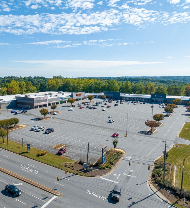
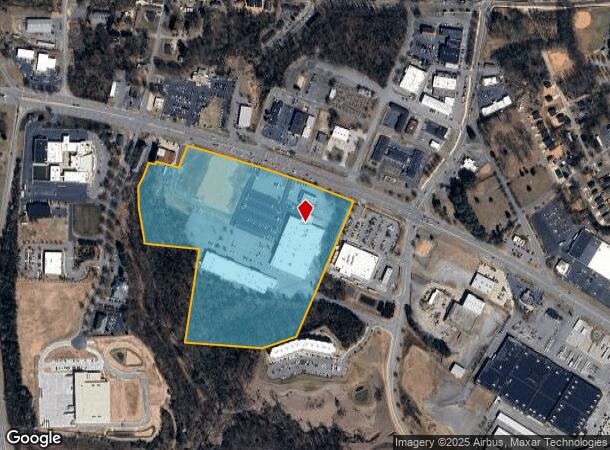
509 Us Highway 70 Sw, Hickory, NC 28602
NEARBY LISTINGS FOR SALE OR LEASE
Property Detail
509 Us Highway 70 Sw
3702092532070000
A S Abernethy
Stripcommercialcenter
PL 5-83
AE
Catawba
3710370200J
North Carolina
2024
22.78 AC
2025
Catawba County
011101
Charlotte
101,568 SF
Hickory-Lenoir-Morganton, NC
DEMOGRAPHICS near 509 Us Highway 70 Sw
1 Mile
3 Mile
5 Mile
2024 Total Population
4,232
31,023
67,903
2029 Population
4,477
32,431
70,655
Pop Growth 2024-2029
+ 5.79%
+ 4.54%
+ 4.05%
Average Age
39
40
41
2024 Total Households
1,744
12,756
28,099
HH Growth 2024-2029
+ 5.79%
+ 4.54%
+ 4.07%
Median Household Inc
$24,374
$49,740
$54,994
Avg Household Size
2.20
2.30
2.30
2024 Avg HH Vehicles
1.00
2.00
2.00
Median Home Value
$124,069
$168,358
$180,496
Median Year Built
1966
1972
1979
Nearby Places
- Restaurants
- Banks
- Shops
- Fitness
- Groceries
SALE & LEASE HISTORY
LISTING DATE
SALE/LEASE

Nov 09, 2023
For Lease
Feb 21, 2025
For Lease
Feb 02, 2017
For Lease
Nearby Properties
Address
Land Use
TOTAL SIZE
Lot Size
Zoning
Address
Land Use
TOTAL SIZE
Lot Size
Zoning
10,422 SF
4.23 AC
OI
Address
Land Use
TOTAL SIZE
Lot Size
Zoning
30,725 SF
17.17 AC
PD
Address
Land Use
TOTAL SIZE
Lot Size
Zoning
19.87 AC
OI
Address
Land Use
TOTAL SIZE
Lot Size
Zoning
27.56 AC
OI
Address
Land Use
TOTAL SIZE
Lot Size
Zoning
19,444 SF
8.84 AC
PD
Address
Land Use
TOTAL SIZE
Lot Size
Zoning
57,658 SF
10.64 AC
OI
Address
Land Use
TOTAL SIZE
Lot Size
Zoning
31,854 SF
24.55 AC
PD
Address
Land Use
TOTAL SIZE
Lot Size
Zoning
9,376 SF
0.75 AC
C-1
Address
Land Use
TOTAL SIZE
Lot Size
Zoning
311,263 SF
37.58 AC
IND
Address
Land Use
TOTAL SIZE
Lot Size
Zoning
125,920 SF
19.53 AC
C-3
Address
Land Use
TOTAL SIZE
Lot Size
Zoning
7,240 SF
INDUSTRIAL
Address
Land Use
TOTAL SIZE
Lot Size
Zoning
30,415 SF
1.59 AC
C-1
Address
Land Use
TOTAL SIZE
Lot Size
Zoning
234,541 SF
9.07 AC
C-3
Address
Land Use
TOTAL SIZE
Lot Size
Zoning
146,932 SF
27.08 AC
C-3
Address
Land Use
TOTAL SIZE
Lot Size
Zoning
90,440 SF
5.17 AC
OI
Address
Land Use
TOTAL SIZE
Lot Size
Zoning
9,950 SF
9.42 AC
R-3
Address
Land Use
TOTAL SIZE
Lot Size
Zoning
8,960 SF
14.07 AC
R-4
Address
Land Use
TOTAL SIZE
Lot Size
Zoning
385,204 SF
14.33 AC
C-3
Address
Land Use
TOTAL SIZE
Lot Size
Zoning
14.15 AC
OI
Address
Land Use
TOTAL SIZE
Lot Size
Zoning
60,130 SF
4.02 AC
IND
Address
Land Use
TOTAL SIZE
Lot Size
Zoning
8.36 AC
OI
Address
Land Use
TOTAL SIZE
Lot Size
Zoning
39,752 SF
11.46 AC
PD
Address
Land Use
TOTAL SIZE
Lot Size
Zoning
82,969 SF
19.30 AC
C-3
Address
Land Use
TOTAL SIZE
Lot Size
Zoning
22.70 AC
R-2
Address
Land Use
TOTAL SIZE
Lot Size
Zoning
123,532 SF
9.89 AC
PD
Address
Land Use
TOTAL SIZE
Lot Size
Zoning
137,227 SF
12.03 AC
NC
Address
Land Use
TOTAL SIZE
Lot Size
Zoning
44,116 SF
6.33 AC
OI
Address
Land Use
TOTAL SIZE
Lot Size
Zoning
30,589 SF
3.64 AC
C-3
Address
Land Use
TOTAL SIZE
Lot Size
Zoning
301,264 SF
19.88 AC
I
Address
Land Use
TOTAL SIZE
Lot Size
Zoning
2.36 AC
C-1
The World's #1 Commercial Real Estate Marketplace
Connect with us
© 2025 CoStar Group
The information above has been obtained from sources believed reliable. While we do not doubt its accuracy we have not verified it and make no guarantee, warranty or representation about it. It is your responsibility to independently confirm its accuracy and completeness. Any projections, opinions, assumptions, or estimates used are for example only and do not represent the current or future performance of the property. The value of this transaction to you depends on tax and other factors which should be evaluated by your tax, financial, and legal advisors. You and your advisors should conduct a careful, independent investigation of the property to determine to your satisfaction the suitability of the property for your needs.