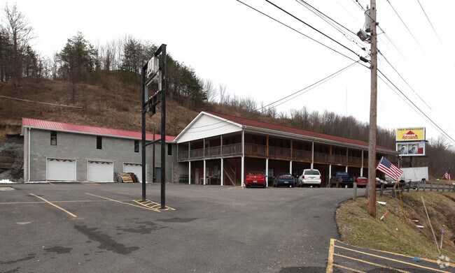
Property Record
5270 13Th St, Ashland, KY 41102

NEARBY LISTINGS FOR SALE OR LEASE
Property Detail
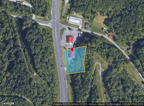
5270 13Th St
024-05-00-003.18
Clinton Tr
Officebuilding
CLINTON TRACT 1.32 ACRES US 60 CLINTON TRACT
X
Boyd
21019C0058D
Kentucky
2024
1.32 AC
2024
Greater Ashland
030600
Huntington/Ashland
8,000 SF
Huntington-Ashland, WV-KY-OH
DEMOGRAPHICS near 5270 13Th St
1 Mile
3 Mile
5 Mile
2024 Total Population
1,062
27,083
48,273
2029 Population
1,055
26,785
47,618
Pop Growth 2024-2029
(0.66%)
(1.10%)
(1.36%)
Average Age
42
42
42
2024 Total Households
383
11,132
19,814
HH Growth 2024-2029
(0.78%)
(1.10%)
(1.29%)
Median Household Inc
$70,416
$54,161
$52,613
Avg Household Size
2.40
2.30
2.30
2024 Avg HH Vehicles
2.00
2.00
2.00
Median Home Value
$166,917
$125,130
$125,900
Median Year Built
1972
1969
1969
Nearby Places
Map Layers
Map Styles
 Street
 Aerial
- Restaurants
- Banks
- Shops
- Fitness
- Groceries
PUBLIC TRANSPORTATION
COMMUTER RAIL
Ashland Amtrak Station (Cardinal - Amtrak)
DRIVE
WALK
Distance
Ashland Amtrak Station (Cardinal - Amtrak)
6 min
3.7 mi
AIRPORT
Tri-State/Milton J Ferguson Field
DRIVE
WALK
Distance
Tri-State/Milton J Ferguson Field
26 min
14.2 mi
Freight Ports
Port of Toledo
DRIVE
WALK
Distance
Port of Toledo
337 min
260.7 mi
Nearby Properties
Address
Land Use
TOTAL SIZE
Lot Size
Zoning
Address
Land Use
TOTAL SIZE
Lot Size
Zoning
36.49 AC
OTHER
Address
Land Use
TOTAL SIZE
Lot Size
Zoning
1.94 AC
Z03
Address
Land Use
TOTAL SIZE
Lot Size
Zoning
16.29 AC
COMMERCIAL
Address
Land Use
TOTAL SIZE
Lot Size
Zoning
91,786 SF
2.93 AC
Address
Land Use
TOTAL SIZE
Lot Size
Zoning
11 AC
COMMERCIAL
Address
Land Use
TOTAL SIZE
Lot Size
Zoning
22 AC
OTHER
Address
Land Use
TOTAL SIZE
Lot Size
Zoning
22,592 SF
43.50 AC
OTHER
Address
Land Use
TOTAL SIZE
Lot Size
Zoning
33,980 SF
2.03 AC
COMMERCIAL
Address
Land Use
TOTAL SIZE
Lot Size
Zoning
54.65 AC
Address
Land Use
TOTAL SIZE
Lot Size
Zoning
6,678 SF
8.57 AC
COMMERCIAL
Address
Land Use
TOTAL SIZE
Lot Size
Zoning
4 AC
Z01
Address
Land Use
TOTAL SIZE
Lot Size
Zoning
7.76 AC
Z03
Address
Land Use
TOTAL SIZE
Lot Size
Zoning
35,506 SF
6 AC
OTHER
Address
Land Use
TOTAL SIZE
Lot Size
Zoning
8,379 SF
7.76 AC
COMMERCIAL
Address
Land Use
TOTAL SIZE
Lot Size
Zoning
36,866 SF
4.70 AC
OTHER
Address
Land Use
TOTAL SIZE
Lot Size
Zoning
0.39 AC
COMMERCIAL
Address
Land Use
TOTAL SIZE
Lot Size
Zoning
9,576 SF
12.29 AC
COMMERCIAL
Address
Land Use
TOTAL SIZE
Lot Size
Zoning
Address
Land Use
TOTAL SIZE
Lot Size
Zoning
20,018 SF
0.36 AC
OTHER
Address
Land Use
TOTAL SIZE
Lot Size
Zoning
22,236 SF
3.96 AC
RESIDENTIA
Address
Land Use
TOTAL SIZE
Lot Size
Zoning
44,650 SF
7.81 AC
Z02
Address
Land Use
TOTAL SIZE
Lot Size
Zoning
0.57 AC
RESIDENTIA
Address
Land Use
TOTAL SIZE
Lot Size
Zoning
6,840 SF
24 AC
COMMERCIAL
Address
Land Use
TOTAL SIZE
Lot Size
Zoning
1.02 AC
COMMERCIAL
Address
Land Use
TOTAL SIZE
Lot Size
Zoning
9.03 AC
Z02
Address
Land Use
TOTAL SIZE
Lot Size
Zoning
Address
Land Use
TOTAL SIZE
Lot Size
Zoning
2.44 AC
COMMERCIAL
Address
Land Use
TOTAL SIZE
Lot Size
Zoning
Address
Land Use
TOTAL SIZE
Lot Size
Zoning
1.09 AC
COMMERCIAL
Address
Land Use
TOTAL SIZE
Lot Size
Zoning
6 AC
COMMERCIAL
The World's #1 Commercial Real Estate Marketplace
Connect with us
© 2025 CoStar Group
The information above has been obtained from sources believed reliable. While we do not doubt its accuracy we have not verified it and make no guarantee, warranty or representation about it. It is your responsibility to independently confirm its accuracy and completeness. Any projections, opinions, assumptions, or estimates used are for example only and do not represent the current or future performance of the property. The value of this transaction to you depends on tax and other factors which should be evaluated by your tax, financial, and legal advisors. You and your advisors should conduct a careful, independent investigation of the property to determine to your satisfaction the suitability of the property for your needs.