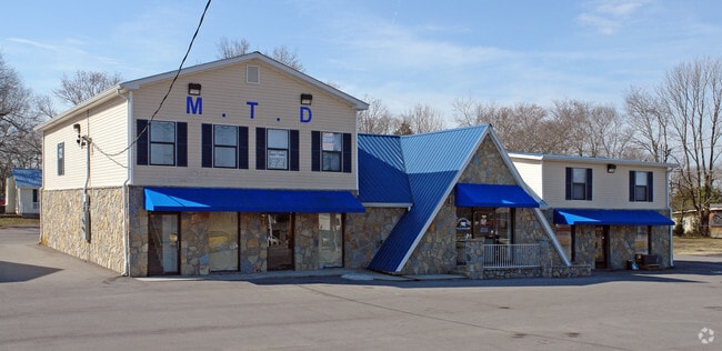
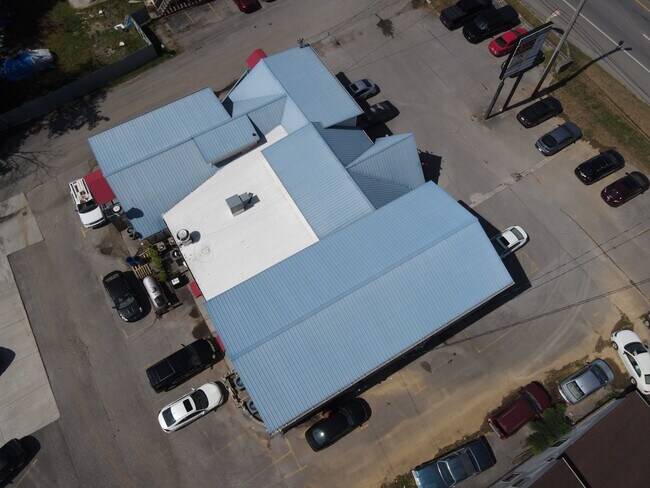
Property Record
111 Glendale Dr, La Vergne, TN 37086
NEARBY LISTINGS FOR SALE OR LEASE
Property Detail
111 Glendale Dr
Nashville-Davidson--Murfreesboro--Franklin, TN
Glendale
018A-A-014.00-000
134.3 X 114.4 IRR
Commercialnec
Rutherford
X
Tennessee
47149C0015J
7
2025
0.33 AC
2025
Rutherford County
040105
Nashville
1,416 SF
DEMOGRAPHICS near 111 Glendale Dr
1 mile
3 mile
5 mile
2024 Total Population
7,868
51,673
122,678
2029 Population
8,892
57,570
133,904
Pop Growth 2024-2029
+ 13.01%
+ 11.41%
+ 9.15%
Average Age
35
35
35
2024 Total Households
2,724
17,479
42,803
HH Growth 2024-2029
+ 12.48%
+ 11.01%
+ 8.73%
Median Household Inc
$61,344
$70,261
$70,874
Avg Household Size
2.80
2.90
2.80
2024 Avg HH Vehicles
2.00
2.00
2.00
Median Home Value
$197,203
$231,320
$259,261
Median Year Built
1999
1998
1999
Nearby Places
Map Layers
Map Styles
 Street
 Aerial
Transit
 Traffic
 Biking
Places
Listings with unknown addresses are not visible on the map
- Restaurants
- Banks
- Shops
- Fitness
- Groceries
PUBLIC TRANSPORTATION
AIRPORT
Nashville International
Drive
Walk
Distance
Nashville International
16 min
10.0 mi
Freight Ports
Port of Mobile
Drive
Walk
Distance
Port of Mobile
496 min
452.1 mi
SALE & LEASE HISTORY
LISTING DATE
SALE/LEASE

Sep 22, 2023
For Sale
Mar 09, 2022
For Lease
Mar 08, 2017
For Sale
Dec 03, 2018
For Lease
Nearby Properties
Address
Land Use
TOTAL SIZE
Lot Size
Zoning
Address
Land Use
TOTAL SIZE
Lot Size
Zoning
28,908 SF
21.55 AC
MULTIZONE
Address
Land Use
TOTAL SIZE
Lot Size
Zoning
404,723 SF
1,495 AC
Address
Land Use
TOTAL SIZE
Lot Size
Zoning
367,058 SF
112 AC
Address
Land Use
TOTAL SIZE
Lot Size
Zoning
129,800 SF
73.44 AC
MULTIZONE
Address
Land Use
TOTAL SIZE
Lot Size
Zoning
618,332 SF
45.75 AC
Address
Land Use
TOTAL SIZE
Lot Size
Zoning
564,124 SF
37.66 AC
Address
Land Use
TOTAL SIZE
Lot Size
Zoning
377,869 SF
26.47 AC
Address
Land Use
TOTAL SIZE
Lot Size
Zoning
12,156 SF
122.05 AC
IR
Address
Land Use
TOTAL SIZE
Lot Size
Zoning
323,961 SF
27.38 AC
I-2
Address
Land Use
TOTAL SIZE
Lot Size
Zoning
4,709 SF
25.76 AC
RM14
Address
Land Use
TOTAL SIZE
Lot Size
Zoning
5,352 SF
30 AC
RMF
Address
Land Use
TOTAL SIZE
Lot Size
Zoning
4,974 SF
18.91 AC
C2
Address
Land Use
TOTAL SIZE
Lot Size
Zoning
301,272 SF
26.09 AC
Address
Land Use
TOTAL SIZE
Lot Size
Zoning
28,187 SF
14 AC
SP
Address
Land Use
TOTAL SIZE
Lot Size
Zoning
516,516 SF
28.39 AC
MULTIZONE
Address
Land Use
TOTAL SIZE
Lot Size
Zoning
526,143 SF
25.75 AC
IR
Address
Land Use
TOTAL SIZE
Lot Size
Zoning
570,000 SF
36.49 AC
IR
Address
Land Use
TOTAL SIZE
Lot Size
Zoning
588,845 SF
72.56 AC
Address
Land Use
TOTAL SIZE
Lot Size
Zoning
512,464 SF
42.43 AC
IR
Address
Land Use
TOTAL SIZE
Lot Size
Zoning
7,720 SF
31.19 AC
IR
Address
Land Use
TOTAL SIZE
Lot Size
Zoning
202,737 SF
41 AC
Address
Land Use
TOTAL SIZE
Lot Size
Zoning
132,470 SF
42.16 AC
Address
Land Use
TOTAL SIZE
Lot Size
Zoning
603,578 SF
47.11 AC
Address
Land Use
TOTAL SIZE
Lot Size
Zoning
63,700 SF
23.70 AC
Address
Land Use
TOTAL SIZE
Lot Size
Zoning
484,476 SF
30.01 AC
Address
Land Use
TOTAL SIZE
Lot Size
Zoning
2,196,000 SF
135.70 AC
Address
Land Use
TOTAL SIZE
Lot Size
Zoning
768,304 SF
40.03 AC
I-2
Address
Land Use
TOTAL SIZE
Lot Size
Zoning
4,489 SF
17.51 AC
IR
Address
Land Use
TOTAL SIZE
Lot Size
Zoning
195,626 SF
40.50 AC
Address
Land Use
TOTAL SIZE
Lot Size
Zoning
212,268 SF
49 AC
The World's #1 Commercial Real Estate Marketplace
Connect with us
© 2026 CoStar Group
The information above has been obtained from sources believed reliable. While we do not doubt its accuracy we have not verified it and make no guarantee, warranty or representation about it. It is your responsibility to independently confirm its accuracy and completeness. Any projections, opinions, assumptions, or estimates used are for example only and do not represent the current or future performance of the property. The value of this transaction to you depends on tax and other factors which should be evaluated by your tax, financial, and legal advisors. You and your advisors should conduct a careful, independent investigation of the property to determine to your satisfaction the suitability of the property for your needs.