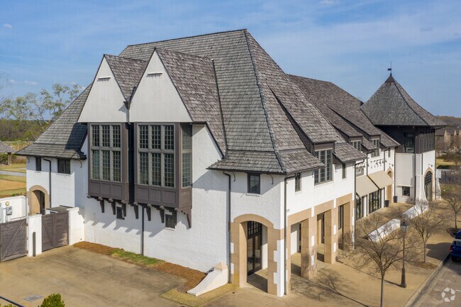
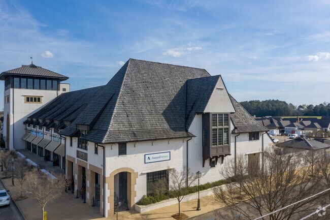
Property Record
5272 Hampstead High St, Montgomery, AL 36116

NEARBY LISTINGS FOR SALE OR LEASE
Property Detail
5272 Hampstead High St
Montgomery, AL
Hampstead 1
16-03-05-2-000-005.000
1603052000005000
Storebuilding
Montgomery
X
Alabama
01101C0233H
1
2025
0.42 AC
2025
North Montgomery
005611
Montgomery
18,193 SF
DEMOGRAPHICS near 5272 Hampstead High St
1 Mile
3 Mile
5 Mile
2024 Total Population
2,225
35,435
85,002
2029 Population
2,205
34,233
82,080
Pop Growth 2024-2029
(0.90%)
(3.39%)
(3.44%)
Average Age
38
36
38
2024 Total Households
955
14,658
36,143
HH Growth 2024-2029
(1.26%)
(3.57%)
(3.54%)
Median Household Inc
$87,058
$63,745
$58,727
Avg Household Size
2.30
2.40
2.30
2024 Avg HH Vehicles
2.00
2.00
2.00
Median Home Value
$353,734
$197,020
$185,905
Median Year Built
2010
1994
1989
Nearby Places
Map Layers
Map Styles
 Street
 Aerial
- Restaurants
- Banks
- Shops
- Fitness
- Groceries
PUBLIC TRANSPORTATION
AIRPORT
Montgomery Regional (Dannelly Field)
DRIVE
WALK
Distance
Montgomery Regional (Dannelly Field)
20 min
14.9 mi
Freight Ports
Port of Panama City
DRIVE
WALK
Distance
Port of Panama City
227 min
179.9 mi
SALE & LEASE HISTORY
LISTING DATE
SALE/LEASE

Oct 01, 2019
For Lease
Nearby Properties
Address
Land Use
TOTAL SIZE
Lot Size
Zoning
Address
Land Use
TOTAL SIZE
Lot Size
Zoning
4,998 SF
27.50 AC
R-65-M
Address
Land Use
TOTAL SIZE
Lot Size
Zoning
16,400 SF
28.35 AC
R-65-M
Address
Land Use
TOTAL SIZE
Lot Size
Zoning
15,932 SF
25.50 AC
R-60-M
Address
Land Use
TOTAL SIZE
Lot Size
Zoning
47,292 SF
63.99 AC
Address
Land Use
TOTAL SIZE
Lot Size
Zoning
23,642 SF
13.70 AC
PUD
Address
Land Use
TOTAL SIZE
Lot Size
Zoning
57,408 SF
24.61 AC
Address
Land Use
TOTAL SIZE
Lot Size
Zoning
1,554 SF
18.26 AC
R-75-M
Address
Land Use
TOTAL SIZE
Lot Size
Zoning
10,317 SF
16.70 AC
AGR-1
Address
Land Use
TOTAL SIZE
Lot Size
Zoning
30,536 SF
18.06 AC
AGR-1
Address
Land Use
TOTAL SIZE
Lot Size
Zoning
56,446 SF
18.67 AC
PUD
Address
Land Use
TOTAL SIZE
Lot Size
Zoning
208,584 SF
21.10 AC
B-3
Address
Land Use
TOTAL SIZE
Lot Size
Zoning
21,634 SF
6.64 AC
Address
Land Use
TOTAL SIZE
Lot Size
Zoning
3,312 SF
15.73 AC
R-65-M
Address
Land Use
TOTAL SIZE
Lot Size
Zoning
7,683 SF
8.11 AC
PUD
Address
Land Use
TOTAL SIZE
Lot Size
Zoning
49,810 SF
12.40 AC
B-2
Address
Land Use
TOTAL SIZE
Lot Size
Zoning
14,409 SF
16.01 AC
B-3
Address
Land Use
TOTAL SIZE
Lot Size
Zoning
2,164 SF
7.50 AC
R-60-A
Address
Land Use
TOTAL SIZE
Lot Size
Zoning
44,082 SF
5.95 AC
Address
Land Use
TOTAL SIZE
Lot Size
Zoning
1,747 SF
7 AC
R-65-M
Address
Land Use
TOTAL SIZE
Lot Size
Zoning
7,482 SF
9.30 AC
R-60-M
Address
Land Use
TOTAL SIZE
Lot Size
Zoning
918 SF
8.86 AC
R-65-M
Address
Land Use
TOTAL SIZE
Lot Size
Zoning
10,314 SF
6.92 AC
PUD
Address
Land Use
TOTAL SIZE
Lot Size
Zoning
12,311 SF
11.85 AC
B-3
Address
Land Use
TOTAL SIZE
Lot Size
Zoning
3,136 SF
9.26 AC
R-65-M
Address
Land Use
TOTAL SIZE
Lot Size
Zoning
13,369 SF
14 AC
B-3
Address
Land Use
TOTAL SIZE
Lot Size
Zoning
23,923 SF
19.61 AC
AGR-1
Address
Land Use
TOTAL SIZE
Lot Size
Zoning
5,400 SF
12.61 AC
M-1
Address
Land Use
TOTAL SIZE
Lot Size
Zoning
8,580 SF
6.80 AC
R-65-M
Address
Land Use
TOTAL SIZE
Lot Size
Zoning
8,924 SF
5.80 AC
Address
Land Use
TOTAL SIZE
Lot Size
Zoning
1,765 SF
5.84 AC
R-65-M
The World's #1 Commercial Real Estate Marketplace
Connect with us
© 2026 CoStar Group
The information above has been obtained from sources believed reliable. While we do not doubt its accuracy we have not verified it and make no guarantee, warranty or representation about it. It is your responsibility to independently confirm its accuracy and completeness. Any projections, opinions, assumptions, or estimates used are for example only and do not represent the current or future performance of the property. The value of this transaction to you depends on tax and other factors which should be evaluated by your tax, financial, and legal advisors. You and your advisors should conduct a careful, independent investigation of the property to determine to your satisfaction the suitability of the property for your needs.