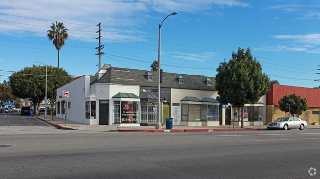
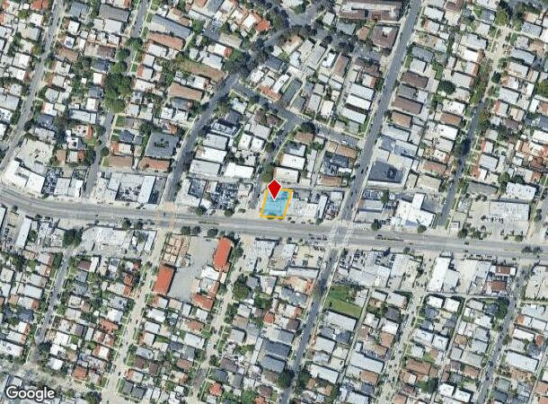
Property Record
5275 W Pico Blvd, Los Angeles, CA 90019

Current Lease Availabilities
NEARBY LISTINGS FOR SALE OR LEASE
Property Detail
5275 W Pico Blvd
Los Angeles-Long Beach-Glendale, CA
4588
5085-036-018
TRACT NO 4588 EX OF ST LOTS 228 AND LOT 229
Storemultistory
Los Angeles
X
California
06037C1611G
228
2024
0.19 AC
2025
Miracle Mile
217102
Los Angeles
5,269 SF
DEMOGRAPHICS near 5275 W Pico Blvd
1 Mile
3 Mile
5 Mile
2024 Total Population
46,207
390,793
1,122,828
2029 Population
45,082
381,570
1,096,932
Pop Growth 2024-2029
(2.43%)
(2.36%)
(2.31%)
Average Age
40
40
40
2024 Total Households
19,077
166,847
470,922
HH Growth 2024-2029
(2.65%)
(2.54%)
(2.37%)
Median Household Inc
$78,155
$73,581
$66,051
Avg Household Size
2.30
2.30
2.30
2024 Avg HH Vehicles
2.00
1.00
1.00
Median Home Value
$1,059,383
$1,050,033
$1,030,655
Median Year Built
1948
1955
1960
Nearby Places
- Restaurants
- Banks
- Shops
- Fitness
- Groceries
PUBLIC TRANSPORTATION
COMMUTER RAIL
Union Station (91 Line - Southern California Regional Rail Authority (Metrolink), Antelope Valley Line - Southern California Regional Rail Authority (Metrolink), Orange County Line - Southern California Regional Rail Authority (Metrolink), Riverside Line - Southern California Regional Rail Authority (Metrolink), San Bernardino Line - Southern California Regional Rail Authority (Metrolink), Ventura County Line - Southern California Regional Rail Authority (Metrolink))
DRIVE
WALK
Distance
Union Station (91 Line - Southern California Regional Rail Authority (Metrolink), Antelope Valley Line - Southern California Regional Rail Authority (Metrolink), Orange County Line - Southern California Regional Rail Authority (Metrolink), Riverside Line - Southern California Regional Rail Authority (Metrolink), San Bernardino Line - Southern California Regional Rail Authority (Metrolink), Ventura County Line - Southern California Regional Rail Authority (Metrolink))
17 min
9.7 mi
AIRPORT
Bob Hope
DRIVE
WALK
Distance
Bob Hope
32 min
12.6 mi
Los Angeles International
DRIVE
WALK
Distance
Los Angeles International
23 min
17.0 mi
Long Beach (Daugherty Field)
DRIVE
WALK
Distance
Long Beach (Daugherty Field)
32 min
28.3 mi
Freight Ports
Port of Long Beach
DRIVE
WALK
Distance
Port of Long Beach
1 min
21.6 mi
Nearby Properties
Address
Land Use
TOTAL SIZE
Lot Size
Zoning
Address
Land Use
TOTAL SIZE
Lot Size
Zoning
2,529,036 SF
8.48 AC
LAC2
Address
Land Use
TOTAL SIZE
Lot Size
Zoning
1,447,077 SF
10.63 AC
LAC2
Address
Land Use
TOTAL SIZE
Lot Size
Zoning
436,774 SF
1.49 AC
LAC2
Address
Land Use
TOTAL SIZE
Lot Size
Zoning
1,002,990 SF
8.42 AC
LAC4
Address
Land Use
TOTAL SIZE
Lot Size
Zoning
252,523 SF
2.26 AC
LAC2
Address
Land Use
TOTAL SIZE
Lot Size
Zoning
597,713 SF
11.18 AC
CCS1YY
Address
Land Use
TOTAL SIZE
Lot Size
Zoning
871,235 SF
14.56 AC
LAC2
Address
Land Use
TOTAL SIZE
Lot Size
Zoning
476,779 SF
1.57 AC
LAC4
Address
Land Use
TOTAL SIZE
Lot Size
Zoning
754,581 SF
3.75 AC
LAC1
Address
Land Use
TOTAL SIZE
Lot Size
Zoning
728,063 SF
2.08 AC
LAC4
Address
Land Use
TOTAL SIZE
Lot Size
Zoning
472,363 SF
3.24 AC
LAC4
Address
Land Use
TOTAL SIZE
Lot Size
Zoning
515,531 SF
14.65 AC
LAC2
Address
Land Use
TOTAL SIZE
Lot Size
Zoning
368,411 SF
10.91 AC
C2-2D-CPIO
Address
Land Use
TOTAL SIZE
Lot Size
Zoning
793,274 SF
7.80 AC
LAR4
Address
Land Use
TOTAL SIZE
Lot Size
Zoning
23,312 SF
11.08 AC
C2-2D-CPIO
Address
Land Use
TOTAL SIZE
Lot Size
Zoning
110,580 SF
6.88 AC
LAC2
Address
Land Use
TOTAL SIZE
Lot Size
Zoning
416,078 SF
2.88 AC
WDC4*
Address
Land Use
TOTAL SIZE
Lot Size
Zoning
453,182 SF
2.76 AC
LAC4
Address
Land Use
TOTAL SIZE
Lot Size
Zoning
255,868 SF
9.58 AC
WDC2C*
Address
Land Use
TOTAL SIZE
Lot Size
Zoning
8.93 AC
LAC2
Address
Land Use
TOTAL SIZE
Lot Size
Zoning
679,557 SF
6.41 AC
LAC2
Address
Land Use
TOTAL SIZE
Lot Size
Zoning
786,423 SF
11.74 AC
LAC2
Address
Land Use
TOTAL SIZE
Lot Size
Zoning
634,370 SF
1.89 AC
BHC3*
Address
Land Use
TOTAL SIZE
Lot Size
Zoning
490,689 SF
3.60 AC
LAM1
Address
Land Use
TOTAL SIZE
Lot Size
Zoning
78,793 SF
3.53 AC
LAMR1
Address
Land Use
TOTAL SIZE
Lot Size
Zoning
291,714 SF
1.47 AC
BHC3
Address
Land Use
TOTAL SIZE
Lot Size
Zoning
366,349 SF
2.98 AC
WDC2C*
Address
Land Use
TOTAL SIZE
Lot Size
Zoning
269,116 SF
2.43 AC
LAC2
Address
Land Use
TOTAL SIZE
Lot Size
Zoning
426,106 SF
2.34 AC
BHC3*
Address
Land Use
TOTAL SIZE
Lot Size
Zoning
274,892 SF
3.53 AC
CCC3EY
The World's #1 Commercial Real Estate Marketplace
Connect with us
© 2025 CoStar Group
The information above has been obtained from sources believed reliable. While we do not doubt its accuracy we have not verified it and make no guarantee, warranty or representation about it. It is your responsibility to independently confirm its accuracy and completeness. Any projections, opinions, assumptions, or estimates used are for example only and do not represent the current or future performance of the property. The value of this transaction to you depends on tax and other factors which should be evaluated by your tax, financial, and legal advisors. You and your advisors should conduct a careful, independent investigation of the property to determine to your satisfaction the suitability of the property for your needs.