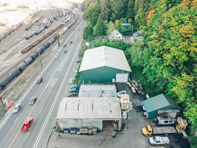
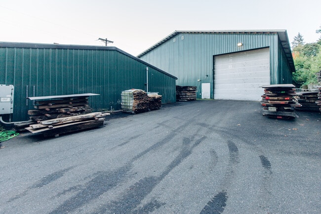
Property Record
5275 Nw Saint Helens Rd, Portland, OR 97210

Current Lease Availabilities
Industrial LEASE
$8.40 - $9.60 SF/YR
4,550 - 12,550 SF
Property Detail
5275 Nw Saint Helens Rd
R315828
SECTION 19 1N 1E, TL 400 1.03 ACRES
Industrialgeneral
MULTNOMAH
IH
Oregon
2025
0.93 AC
2025
Guilds Lake
004300
Portland
5,000 SF
Portland-Vancouver-Hillsboro, OR-WA
NEARBY LISTINGS FOR SALE OR LEASE
DEMOGRAPHICS near 5275 Nw Saint Helens Rd
1 mile
3 mile
5 mile
2025 Total Population
105
78,337
280,731
2030 Population
104
77,971
281,494
Pop Growth 2025-2030
(0.95%)
(0.47%)
+ 0.27%
Average Age
43
39
40
2025 Total Households
42
32,117
128,177
HH Growth 2025-2030
0.00%
(0.58%)
+ 0.21%
Median Household Inc
$104,167
$109,898
$99,430
Avg Household Size
2.40
2.30
2.10
2025 Avg HH Vehicles
2.00
2.00
1.00
Median Home Value
$750,000
$671,135
$715,233
Median Year Built
1964
1970
1978
Nearby Places
Map Layers
Map Styles
 Street
 Aerial
Layers
 Traffic
 Biking
Places
Listings with unknown addresses are not visible on the map
- Restaurants
- Banks
- Shops
- Fitness
- Groceries
PUBLIC TRANSPORTATION
COMMUTER RAIL
Drive
Walk
Distance
10 min
4.2 mi
AIRPORT
Portland International
Drive
Walk
Distance
Portland International
26 min
13.6 mi
Nearby Properties
Address
Land Use
TOTAL SIZE
Lot Size
Zoning
Address
Land Use
TOTAL SIZE
Lot Size
Zoning
200,109 SF
70.44 AC
IH
Address
Land Use
TOTAL SIZE
Lot Size
Zoning
882,480 SF
80.73 AC
CI1
Address
Land Use
TOTAL SIZE
Lot Size
Zoning
326,547 SF
2.42 AC
RH
Address
Land Use
TOTAL SIZE
Lot Size
Zoning
Address
Land Use
TOTAL SIZE
Lot Size
Zoning
262,045 SF
17.10 AC
R5
Address
Land Use
TOTAL SIZE
Lot Size
Zoning
645,294 SF
5.64 AC
CO2D
Address
Land Use
TOTAL SIZE
Lot Size
Zoning
191,506 SF
10.43 AC
IH
Address
Land Use
TOTAL SIZE
Lot Size
Zoning
537,280 SF
NULL
Address
Land Use
TOTAL SIZE
Lot Size
Zoning
318,562 SF
33.59 AC
CI1
Address
Land Use
TOTAL SIZE
Lot Size
Zoning
Address
Land Use
TOTAL SIZE
Lot Size
Zoning
100 SF
82.93 AC
IH
Address
Land Use
TOTAL SIZE
Lot Size
Zoning
73,657 SF
1.90 AC
CI1
Address
Land Use
TOTAL SIZE
Lot Size
Zoning
8.01 AC
EG2
Address
Land Use
TOTAL SIZE
Lot Size
Zoning
963,658 SF
64.43 AC
IH
Address
Land Use
TOTAL SIZE
Lot Size
Zoning
37,770 SF
6.90 AC
EG2
Address
Land Use
TOTAL SIZE
Lot Size
Zoning
234,039 SF
2.50 AC
CX
Address
Land Use
TOTAL SIZE
Lot Size
Zoning
Address
Land Use
TOTAL SIZE
Lot Size
Zoning
214,582 SF
1.04 AC
CM3
Address
Land Use
TOTAL SIZE
Lot Size
Zoning
610,230 SF
26.65 AC
IH
Address
Land Use
TOTAL SIZE
Lot Size
Zoning
193,616 SF
1.19 AC
CM3
Address
Land Use
TOTAL SIZE
Lot Size
Zoning
Address
Land Use
TOTAL SIZE
Lot Size
Zoning
Address
Land Use
TOTAL SIZE
Lot Size
Zoning
909,769 SF
29.86 AC
IHI
Address
Land Use
TOTAL SIZE
Lot Size
Zoning
229,981 SF
5.29 AC
EG2_EG2C
Address
Land Use
TOTAL SIZE
Lot Size
Zoning
Address
Land Use
TOTAL SIZE
Lot Size
Zoning
147,522 SF
0.85 AC
IG1
Address
Land Use
TOTAL SIZE
Lot Size
Zoning
61,778 SF
1.23 AC
RH
Address
Land Use
TOTAL SIZE
Lot Size
Zoning
223,324 SF
1.19 AC
RH
Address
Land Use
TOTAL SIZE
Lot Size
Zoning
138,932 SF
1.06 AC
CM3
Address
Land Use
TOTAL SIZE
Lot Size
Zoning
215,104 SF
NULL
The World's #1 Commercial Real Estate Marketplace
Connect with us
© 2026 CoStar Group
The information above has been obtained from sources believed reliable. While we do not doubt its accuracy we have not verified it and make no guarantee, warranty or representation about it. It is your responsibility to independently confirm its accuracy and completeness. Any projections, opinions, assumptions, or estimates used are for example only and do not represent the current or future performance of the property. The value of this transaction to you depends on tax and other factors which should be evaluated by your tax, financial, and legal advisors. You and your advisors should conduct a careful, independent investigation of the property to determine to your satisfaction the suitability of the property for your needs.