Property Record
5277 Gratiot Ave, Saint Clair, MI 48079

NEARBY LISTINGS FOR SALE OR LEASE
-
-
View all Saint Clair listings for sale on LoopNet.com
Property Detail
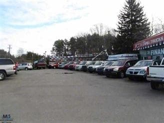
5277 Gratiot Ave
30-002-4025-100
BEG S 61D 17M W 167.7' FROM INT/SEC OF S'LY LINE GRATIOT RD & N & S 1/4 LINE, TH S 29D 56M 33S E 85.98', TH S 0D 1M E 710.28', TH S 61D 9M W 187.61', TH N 0D 1M W 808.78', TH N 61D 17M E 139.37' TO BEG SECTION 2 T5N R16E 3 A
Autorepair
St. Clair
X
Michigan
26147C0345D
3 AC
2025
St Clair & Lapeer Counties
2025
Detroit
640600
Detroit-Warren-Dearborn, MI
3,272 SF
DEMOGRAPHICS near 5277 Gratiot Ave
1 Mile
3 Mile
5 Mile
2024 Total Population
472
9,828
27,978
2029 Population
469
9,802
27,904
Pop Growth 2024-2029
(0.64%)
(0.26%)
(0.26%)
Average Age
43
42
42
2024 Total Households
199
4,078
11,187
HH Growth 2024-2029
(1.01%)
(0.27%)
(0.33%)
Median Household Inc
$82,386
$69,122
$60,787
Avg Household Size
2.30
2.40
2.40
2024 Avg HH Vehicles
2.00
2.00
2.00
Median Home Value
$226,316
$178,194
$180,578
Median Year Built
1975
1977
1980
Nearby Places
Map Layers
Map Styles
 Street
 Aerial
- Restaurants
- Banks
- Shops
- Fitness
- Groceries
PUBLIC TRANSPORTATION
COMMUTER RAIL
DRIVE
WALK
Distance
13 min
6.8 mi
Nearby Properties
Address
Land Use
TOTAL SIZE
Lot Size
Zoning
Address
Land Use
TOTAL SIZE
Lot Size
Zoning
682,515 SF
211.45 AC
M-2
Address
Land Use
TOTAL SIZE
Lot Size
Zoning
79,276 SF
316.65 AC
M-1
Address
Land Use
TOTAL SIZE
Lot Size
Zoning
1,246,586 SF
83.70 AC
M-2
Address
Land Use
TOTAL SIZE
Lot Size
Zoning
98,904 SF
29.48 AC
R1-A
Address
Land Use
TOTAL SIZE
Lot Size
Zoning
79,276 SF
311.74 AC
M-1
Address
Land Use
TOTAL SIZE
Lot Size
Zoning
204,347 SF
35.13 AC
C-2
Address
Land Use
TOTAL SIZE
Lot Size
Zoning
80,662 SF
R1-A
Address
Land Use
TOTAL SIZE
Lot Size
Zoning
138,360 SF
6.01 AC
M-1
Address
Land Use
TOTAL SIZE
Lot Size
Zoning
Address
Land Use
TOTAL SIZE
Lot Size
Zoning
108,767 SF
7.29 AC
R1-A
Address
Land Use
TOTAL SIZE
Lot Size
Zoning
83,623 SF
5.49 AC
M-1
Address
Land Use
TOTAL SIZE
Lot Size
Zoning
250,775 SF
11.29 AC
M-1
Address
Land Use
TOTAL SIZE
Lot Size
Zoning
25,111 SF
90.62 AC
B-2
Address
Land Use
TOTAL SIZE
Lot Size
Zoning
69,440 SF
12.30 AC
C-2
Address
Land Use
TOTAL SIZE
Lot Size
Zoning
100,096 SF
13.85 AC
M-2
Address
Land Use
TOTAL SIZE
Lot Size
Zoning
50,314 SF
58.60 AC
M-2
Address
Land Use
TOTAL SIZE
Lot Size
Zoning
68,348 SF
6.33 AC
M-1
Address
Land Use
TOTAL SIZE
Lot Size
Zoning
28,565 SF
R1-A
Address
Land Use
TOTAL SIZE
Lot Size
Zoning
5,213 SF
45 AC
I-2
Address
Land Use
TOTAL SIZE
Lot Size
Zoning
55,760 SF
7.86 AC
M-1
Address
Land Use
TOTAL SIZE
Lot Size
Zoning
18,000 SF
9.62 AC
M-1
Address
Land Use
TOTAL SIZE
Lot Size
Zoning
29,312 SF
2 AC
R1-A
Address
Land Use
TOTAL SIZE
Lot Size
Zoning
72,284 SF
8.07 AC
C-2
Address
Land Use
TOTAL SIZE
Lot Size
Zoning
129,642 SF
10.49 AC
M-1
Address
Land Use
TOTAL SIZE
Lot Size
Zoning
10,366 SF
2.39 AC
C-3
Address
Land Use
TOTAL SIZE
Lot Size
Zoning
23,067 SF
2.29 AC
RMA
Address
Land Use
TOTAL SIZE
Lot Size
Zoning
24,000 SF
R1-A
Address
Land Use
TOTAL SIZE
Lot Size
Zoning
71,108 SF
5.02 AC
M-2
Address
Land Use
TOTAL SIZE
Lot Size
Zoning
13,532 SF
98.56 AC
CR
Address
Land Use
TOTAL SIZE
Lot Size
Zoning
18,109 SF
120 AC
AG
The World's #1 Commercial Real Estate Marketplace
Connect with us
© 2026 CoStar Group
The information above has been obtained from sources believed reliable. While we do not doubt its accuracy we have not verified it and make no guarantee, warranty or representation about it. It is your responsibility to independently confirm its accuracy and completeness. Any projections, opinions, assumptions, or estimates used are for example only and do not represent the current or future performance of the property. The value of this transaction to you depends on tax and other factors which should be evaluated by your tax, financial, and legal advisors. You and your advisors should conduct a careful, independent investigation of the property to determine to your satisfaction the suitability of the property for your needs.