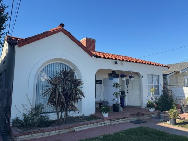
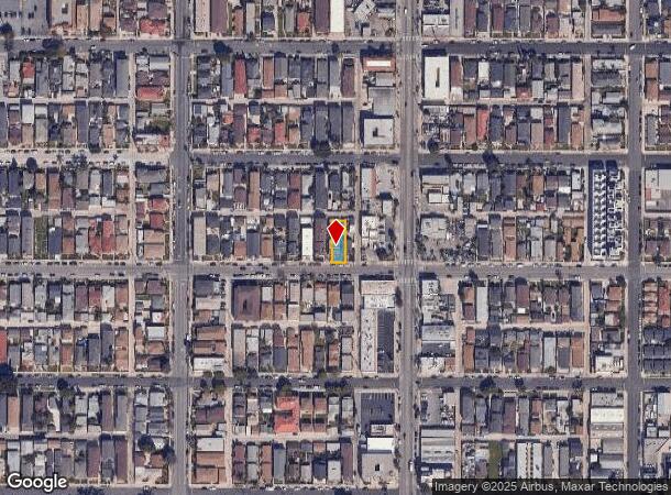
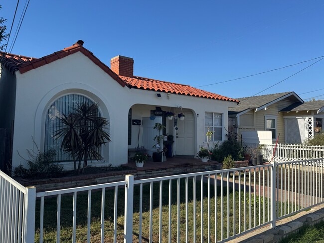
Property Record
528 W 19Th St, San Pedro, CA 90731

This Property Is For Sale
NEARBY LISTINGS FOR SALE OR LEASE
Property Detail
528 W 19Th St
Los Angeles-Long Beach-Glendale, CA
Harbor Sub
7462-007-017
Los Angeles
Duplex
California
X
0.12 AC
06037C2031G
Central San Pedro
1,342 SF
Los Angeles
DEMOGRAPHICS near 528 W 19Th St
1 Mile
3 Mile
5 Mile
2024 Total Population
37,461
89,595
174,244
2029 Population
36,629
87,253
169,289
Pop Growth 2024-2029
(2.22%)
(2.61%)
(2.84%)
Average Age
40
42
41
2024 Total Households
14,505
33,785
60,570
HH Growth 2024-2029
(2.70%)
(3.08%)
(3.23%)
Median Household Inc
$71,373
$91,828
$84,901
Avg Household Size
2.40
2.50
2.70
2024 Avg HH Vehicles
2.00
2.00
2.00
Median Home Value
$777,034
$890,640
$858,500
Median Year Built
1961
1963
1965
Nearby Places
Map Layers
Map Styles
 Street
 Aerial
- Restaurants
- Banks
- Shops
- Fitness
- Groceries
PUBLIC TRANSPORTATION
AIRPORT
Long Beach (Daugherty Field)
DRIVE
WALK
Distance
Long Beach (Daugherty Field)
24 min
14.6 mi
Los Angeles International
DRIVE
WALK
Distance
Los Angeles International
31 min
21.4 mi
John Wayne/Orange County
DRIVE
WALK
Distance
John Wayne/Orange County
46 min
34.8 mi
Freight Ports
Port of Los Angeles
DRIVE
WALK
Distance
Port of Los Angeles
15 min
5.7 mi
Nearby Properties
Address
Land Use
TOTAL SIZE
Lot Size
Zoning
Address
Land Use
TOTAL SIZE
Lot Size
Zoning
414,189 SF
2.45 AC
LAC2
Address
Land Use
TOTAL SIZE
Lot Size
Zoning
426,285 SF
LAC2
Address
Land Use
TOTAL SIZE
Lot Size
Zoning
170,000 SF
7.61 AC
LARD1.5
Address
Land Use
TOTAL SIZE
Lot Size
Zoning
759,851 SF
33.72 AC
LAM3
Address
Land Use
TOTAL SIZE
Lot Size
Zoning
191,424 SF
7.71 AC
LARD1.5
Address
Land Use
TOTAL SIZE
Lot Size
Zoning
269,859 SF
11.14 AC
RPRS-4*
Address
Land Use
TOTAL SIZE
Lot Size
Zoning
512,700 SF
20.65 AC
LAM3
Address
Land Use
TOTAL SIZE
Lot Size
Zoning
131,529 SF
9.83 AC
LAM1
Address
Land Use
TOTAL SIZE
Lot Size
Zoning
173,135 SF
2.05 AC
LAC2
Address
Land Use
TOTAL SIZE
Lot Size
Zoning
169,947 SF
1.81 AC
LAC2
Address
Land Use
TOTAL SIZE
Lot Size
Zoning
340,659 SF
15.14 AC
LAM3
Address
Land Use
TOTAL SIZE
Lot Size
Zoning
233.72 AC
LAM3
Address
Land Use
TOTAL SIZE
Lot Size
Zoning
145,530 SF
5.22 AC
LARD2
Address
Land Use
TOTAL SIZE
Lot Size
Zoning
488,488 SF
1.65 AC
LAC2
Address
Land Use
TOTAL SIZE
Lot Size
Zoning
42,313 SF
27.33 AC
LAR1
Address
Land Use
TOTAL SIZE
Lot Size
Zoning
202,027 SF
4.85 AC
LAP
Address
Land Use
TOTAL SIZE
Lot Size
Zoning
202,544 SF
3.59 AC
LCC3*
Address
Land Use
TOTAL SIZE
Lot Size
Zoning
3,440 SF
19.80 AC
LAM3
Address
Land Use
TOTAL SIZE
Lot Size
Zoning
207,282 SF
11.39 AC
LAM3
Address
Land Use
TOTAL SIZE
Lot Size
Zoning
55,726 SF
1.01 AC
LAC2
Address
Land Use
TOTAL SIZE
Lot Size
Zoning
240,782 SF
12.55 AC
LAM1
Address
Land Use
TOTAL SIZE
Lot Size
Zoning
195,211 SF
4.77 AC
LAP
Address
Land Use
TOTAL SIZE
Lot Size
Zoning
72,960 SF
1.63 AC
LAC2
Address
Land Use
TOTAL SIZE
Lot Size
Zoning
5,484 SF
3.42 AC
LARD1.5
Address
Land Use
TOTAL SIZE
Lot Size
Zoning
4,570 SF
4.03 AC
LAR4
Address
Land Use
TOTAL SIZE
Lot Size
Zoning
23,000 SF
0.60 AC
LAC2
Address
Land Use
TOTAL SIZE
Lot Size
Zoning
93,612 SF
10.09 AC
LAM1
Address
Land Use
TOTAL SIZE
Lot Size
Zoning
157,302 SF
4.10 AC
RPCG*
Address
Land Use
TOTAL SIZE
Lot Size
Zoning
43,798 SF
2.89 AC
LAC2
Address
Land Use
TOTAL SIZE
Lot Size
Zoning
135,389 SF
1.88 AC
LAR4
The World's #1 Commercial Real Estate Marketplace
Connect with us
© 2026 CoStar Group
The information above has been obtained from sources believed reliable. While we do not doubt its accuracy we have not verified it and make no guarantee, warranty or representation about it. It is your responsibility to independently confirm its accuracy and completeness. Any projections, opinions, assumptions, or estimates used are for example only and do not represent the current or future performance of the property. The value of this transaction to you depends on tax and other factors which should be evaluated by your tax, financial, and legal advisors. You and your advisors should conduct a careful, independent investigation of the property to determine to your satisfaction the suitability of the property for your needs.