Property Record
5289 Wilma Edwards Rd, Ellabell, GA 31308
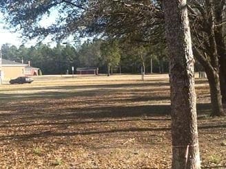
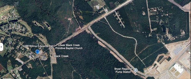
This Property Is For Sale
NEARBY LISTINGS FOR SALE OR LEASE
Property Detail
5289 Wilma Edwards Rd
0251-017-01
FR:C HARRIS MEADOWS PS394:8
Sfr
Bryan
X
Georgia
13029C0090D
1.75 AC
2024
Bryan County
2024
Savannah
920101
Savannah, GA
1,466 SF
DEMOGRAPHICS near 5289 Wilma Edwards Rd
1 Mile
3 Mile
5 Mile
2024 Total Population
672
5,009
7,596
2029 Population
801
5,964
9,015
Pop Growth 2024-2029
+ 19.20%
+ 19.07%
+ 18.68%
Average Age
39
39
39
2024 Total Households
241
1,809
2,749
HH Growth 2024-2029
+ 19.50%
+ 19.18%
+ 18.81%
Median Household Inc
$57,631
$57,172
$58,562
Avg Household Size
2.70
2.70
2.70
2024 Avg HH Vehicles
2.00
2.00
2.00
Median Home Value
$173,809
$171,015
$168,478
Median Year Built
1998
1997
1997
Nearby Places
- Restaurants
- Banks
- Shops
- Fitness
- Groceries
PUBLIC TRANSPORTATION
AIRPORT
Savannah/Hilton Head International
DRIVE
WALK
Distance
Savannah/Hilton Head International
34 min
24.1 mi
Freight Ports
Georgia Ports - Savannah
DRIVE
WALK
Distance
Georgia Ports - Savannah
36 min
26.9 mi
Nearby Properties
Address
Land Use
TOTAL SIZE
Lot Size
Zoning
Address
Land Use
TOTAL SIZE
Lot Size
Zoning
30 AC
I-2
Address
Land Use
TOTAL SIZE
Lot Size
Zoning
499,200 SF
29.58 AC
I-2
Address
Land Use
TOTAL SIZE
Lot Size
Zoning
637,875 SF
74.90 AC
I-1
Address
Land Use
TOTAL SIZE
Lot Size
Zoning
418,951 SF
43.81 AC
I-2
Address
Land Use
TOTAL SIZE
Lot Size
Zoning
604,800 SF
52.70 AC
I-2
Address
Land Use
TOTAL SIZE
Lot Size
Zoning
700,000 SF
56.33 AC
I-2
Address
Land Use
TOTAL SIZE
Lot Size
Zoning
463,250 SF
38.13 AC
I-2
Address
Land Use
TOTAL SIZE
Lot Size
Zoning
633,120 SF
32.43 AC
I-2
Address
Land Use
TOTAL SIZE
Lot Size
Zoning
294,868 SF
32.90 AC
I-2
Address
Land Use
TOTAL SIZE
Lot Size
Zoning
712,200 SF
48.96 AC
I-2
Address
Land Use
TOTAL SIZE
Lot Size
Zoning
98.85 AC
I-2
Address
Land Use
TOTAL SIZE
Lot Size
Zoning
67,986 SF
48.25 AC
RR-1
Address
Land Use
TOTAL SIZE
Lot Size
Zoning
77.63 AC
I-2
Address
Land Use
TOTAL SIZE
Lot Size
Zoning
3.28 AC
I-2
Address
Land Use
TOTAL SIZE
Lot Size
Zoning
54,000 SF
4.12 AC
I-2
Address
Land Use
TOTAL SIZE
Lot Size
Zoning
38,200 SF
27.72 AC
I-2
Address
Land Use
TOTAL SIZE
Lot Size
Zoning
50,000 SF
32.90 AC
I-2
Address
Land Use
TOTAL SIZE
Lot Size
Zoning
57,600 SF
3.32 AC
I-2
Address
Land Use
TOTAL SIZE
Lot Size
Zoning
11,180 SF
20.86 AC
C-I
Address
Land Use
TOTAL SIZE
Lot Size
Zoning
30 AC
I-2
Address
Land Use
TOTAL SIZE
Lot Size
Zoning
17,080 SF
14.91 AC
C-I
Address
Land Use
TOTAL SIZE
Lot Size
Zoning
40.63 AC
I-2
Address
Land Use
TOTAL SIZE
Lot Size
Zoning
10.08 AC
C-I
Address
Land Use
TOTAL SIZE
Lot Size
Zoning
5.48 AC
C-I
Address
Land Use
TOTAL SIZE
Lot Size
Zoning
286.75 AC
R-15
Address
Land Use
TOTAL SIZE
Lot Size
Zoning
4,210 SF
2.43 AC
C-I
Address
Land Use
TOTAL SIZE
Lot Size
Zoning
17.40 AC
C-I/I-2
Address
Land Use
TOTAL SIZE
Lot Size
Zoning
8.22 AC
C-I
Address
Land Use
TOTAL SIZE
Lot Size
Zoning
8.22 AC
C-I
Address
Land Use
TOTAL SIZE
Lot Size
Zoning
5.66 AC
C-I
The World's #1 Commercial Real Estate Marketplace
Connect with us
© 2025 CoStar Group
The information above has been obtained from sources believed reliable. While we do not doubt its accuracy we have not verified it and make no guarantee, warranty or representation about it. It is your responsibility to independently confirm its accuracy and completeness. Any projections, opinions, assumptions, or estimates used are for example only and do not represent the current or future performance of the property. The value of this transaction to you depends on tax and other factors which should be evaluated by your tax, financial, and legal advisors. You and your advisors should conduct a careful, independent investigation of the property to determine to your satisfaction the suitability of the property for your needs.