Property Record
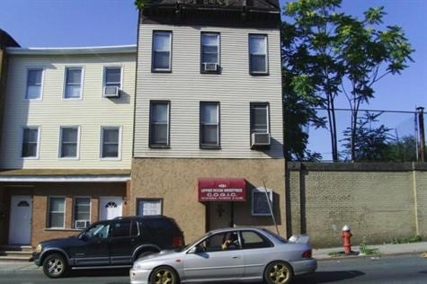
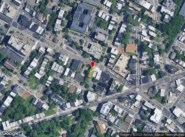
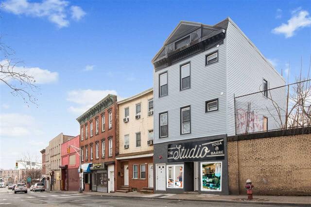
529 Communipaw Ave, Jersey City, NJ 07304
This Property Is For Sale
NEARBY LISTINGS FOR SALE OR LEASE
Property Detail
529 Communipaw Ave
New York-Jersey City-White Plains, NY-NJ
Nicholas Vreeland
06-18702-0000-00010
FACILITY NAME: PARKING AREA
Commercialnec
Hudson
X
New Jersey
34013C0200F
10
2024
0.05 AC
2025
Hudson Waterfront
004300
Northern New Jersey
DEMOGRAPHICS near 529 Communipaw Ave
1 Mile
3 Mile
5 Mile
2024 Total Population
75,097
355,718
1,136,142
2029 Population
71,980
343,765
1,080,859
Pop Growth 2024-2029
(4.15%)
(3.36%)
(4.87%)
Average Age
37
37
39
2024 Total Households
28,836
149,538
513,295
HH Growth 2024-2029
(4.44%)
(3.50%)
(5.23%)
Median Household Inc
$58,585
$98,303
$97,125
Avg Household Size
2.50
2.30
2.10
2024 Avg HH Vehicles
1.00
1.00
1.00
Median Home Value
$404,814
$583,052
$776,106
Median Year Built
1952
1974
1959
Nearby Places
- Restaurants
- Banks
- Shops
- Fitness
- Groceries
PUBLIC TRANSPORTATION
TRANSIT/SUBWAY
Garfield Avenue (West Side Avenue-Tonnelle Avenue - Hudson-Bergen Light Rail (Hudson-Bergen Light Rail))
DRIVE
WALK
Distance
Garfield Avenue (West Side Avenue-Tonnelle Avenue - Hudson-Bergen Light Rail (Hudson-Bergen Light Rail))
2 min
10 min
0.5 mi
Martin Luther King Drive (West Side Avenue-Tonnelle Avenue - Hudson-Bergen Light Rail (Hudson-Bergen Light Rail))
DRIVE
WALK
Distance
Martin Luther King Drive (West Side Avenue-Tonnelle Avenue - Hudson-Bergen Light Rail (Hudson-Bergen Light Rail))
1 min
12 min
0.6 mi
Liberty State Park (22nd Street-Hoboken Terminal - Hudson-Bergen Light Rail (Hudson-Bergen Light Rail), West Side Avenue-Tonnelle Avenue - Hudson-Bergen Light Rail (Hudson-Bergen Light Rail))
DRIVE
WALK
Distance
Liberty State Park (22nd Street-Hoboken Terminal - Hudson-Bergen Light Rail (Hudson-Bergen Light Rail), West Side Avenue-Tonnelle Avenue - Hudson-Bergen Light Rail (Hudson-Bergen Light Rail))
2 min
18 min
1.0 mi
COMMUTER RAIL
Journal Square (Journal Square-33rd Street - Port Authority Trans-Hudson (PATH), Newark Penn Station-World Trade Center - Port Authority Trans-Hudson (PATH))
DRIVE
WALK
Distance
Journal Square (Journal Square-33rd Street - Port Authority Trans-Hudson (PATH), Newark Penn Station-World Trade Center - Port Authority Trans-Hudson (PATH))
3 min
1.5 mi
Grove Street (Journal Square-33rd Street - Port Authority Trans-Hudson (PATH), Newark Penn Station-World Trade Center - Port Authority Trans-Hudson (PATH))
DRIVE
WALK
Distance
Grove Street (Journal Square-33rd Street - Port Authority Trans-Hudson (PATH), Newark Penn Station-World Trade Center - Port Authority Trans-Hudson (PATH))
4 min
1.8 mi
AIRPORT
Newark Liberty International
DRIVE
WALK
Distance
Newark Liberty International
12 min
8.4 mi
LaGuardia
DRIVE
WALK
Distance
LaGuardia
33 min
14.8 mi
John F Kennedy International
DRIVE
WALK
Distance
John F Kennedy International
42 min
23.0 mi
Freight Ports
GCT Bayonne
DRIVE
WALK
Distance
GCT Bayonne
11 min
5.8 mi
Nearby Properties
Address
Land Use
TOTAL SIZE
Lot Size
Zoning
Address
Land Use
TOTAL SIZE
Lot Size
Zoning
9.33 AC
C-1
Address
Land Use
TOTAL SIZE
Lot Size
Zoning
2.38 AC
Address
Land Use
TOTAL SIZE
Lot Size
Zoning
1.75 AC
Address
Land Use
TOTAL SIZE
Lot Size
Zoning
2,157,862 SF
2.23 AC
BPC
Address
Land Use
TOTAL SIZE
Lot Size
Zoning
229.72 AC
Address
Land Use
TOTAL SIZE
Lot Size
Zoning
2,255,659 SF
4.58 AC
BPC
Address
Land Use
TOTAL SIZE
Lot Size
Zoning
Address
Land Use
TOTAL SIZE
Lot Size
Zoning
6.42 AC
Address
Land Use
TOTAL SIZE
Lot Size
Zoning
2,233,692 SF
1.90 AC
BPC
Address
Land Use
TOTAL SIZE
Lot Size
Zoning
2.21 AC
Address
Land Use
TOTAL SIZE
Lot Size
Zoning
1.71 AC
C-1
Address
Land Use
TOTAL SIZE
Lot Size
Zoning
1,909,502 SF
2.37 AC
BPC
Address
Land Use
TOTAL SIZE
Lot Size
Zoning
1,780,030 SF
5.07 AC
BPC
Address
Land Use
TOTAL SIZE
Lot Size
Zoning
1.04 AC
Address
Land Use
TOTAL SIZE
Lot Size
Zoning
1.87 AC
I-2
Address
Land Use
TOTAL SIZE
Lot Size
Zoning
1.84 AC
Address
Land Use
TOTAL SIZE
Lot Size
Zoning
512 SF
1.30 AC
R1
Address
Land Use
TOTAL SIZE
Lot Size
Zoning
11.15 AC
Address
Land Use
TOTAL SIZE
Lot Size
Zoning
2.43 AC
I-2
Address
Land Use
TOTAL SIZE
Lot Size
Zoning
3.43 AC
Address
Land Use
TOTAL SIZE
Lot Size
Zoning
131.26 AC
Address
Land Use
TOTAL SIZE
Lot Size
Zoning
2.82 AC
I-2
Address
Land Use
TOTAL SIZE
Lot Size
Zoning
0.66 AC
Address
Land Use
TOTAL SIZE
Lot Size
Zoning
15.01 AC
I-2
Address
Land Use
TOTAL SIZE
Lot Size
Zoning
1.13 AC
Address
Land Use
TOTAL SIZE
Lot Size
Zoning
Address
Land Use
TOTAL SIZE
Lot Size
Zoning
2.53 AC
I-2
Address
Land Use
TOTAL SIZE
Lot Size
Zoning
1.15 AC
Address
Land Use
TOTAL SIZE
Lot Size
Zoning
Address
Land Use
TOTAL SIZE
Lot Size
Zoning
1,440,960 SF
2.17 AC
BPC
The World's #1 Commercial Real Estate Marketplace
Connect with us
© 2025 CoStar Group
The information above has been obtained from sources believed reliable. While we do not doubt its accuracy we have not verified it and make no guarantee, warranty or representation about it. It is your responsibility to independently confirm its accuracy and completeness. Any projections, opinions, assumptions, or estimates used are for example only and do not represent the current or future performance of the property. The value of this transaction to you depends on tax and other factors which should be evaluated by your tax, financial, and legal advisors. You and your advisors should conduct a careful, independent investigation of the property to determine to your satisfaction the suitability of the property for your needs.