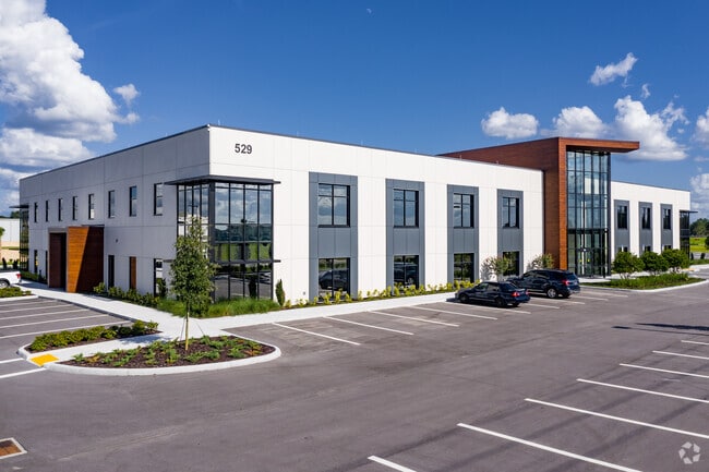
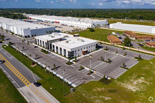
Property Record
529 E Crown Point Rd, Ocoee, FL 34761


Current Lease Availabilities
Property Detail
529 E Crown Point Rd
13-2227-0004-01-001
429 OUTPARCEL 106/3 LOT 1-A
Officebuilding
ORANGE
PUD-IND
Florida
B and X Area of moderate flood hazard, usually the area between the limits of the 100-year and 500-year floods.
1-a
2025
3.02 AC
2025
West Colonial
015001
Orlando
55,594 SF
Orlando-Kissimmee-Sanford, FL
NEARBY LISTINGS FOR SALE OR LEASE
DEMOGRAPHICS near 529 E Crown Point Rd
1 mile
3 mile
5 mile
2025 Total Population
6,275
59,633
146,252
2030 Population
6,849
65,059
159,123
Pop Growth 2025-2030
+ 9.15%
+ 9.10%
+ 8.80%
Average Age
39
40
40
2025 Total Households
2,046
20,373
50,127
HH Growth 2025-2030
+ 9.58%
+ 9.47%
+ 9.21%
Median Household Inc
$96,612
$94,154
$92,183
Avg Household Size
2.90
2.80
2.90
2025 Avg HH Vehicles
2.00
2.00
2.00
Median Home Value
$437,258
$412,188
$419,416
Median Year Built
1999
1996
1997
Nearby Places
Map Layers
Map Styles
 Street
 Aerial
Transit
 Traffic
 Biking
Places
Listings with unknown addresses are not visible on the map
- Restaurants
- Banks
- Shops
- Fitness
- Groceries
PUBLIC TRANSPORTATION
AIRPORT
Orlando International
Drive
Walk
Distance
Orlando International
33 min
24.1 mi
Orlando Sanford International
Drive
Walk
Distance
Orlando Sanford International
50 min
35.0 mi
Freight Ports
Port Canaveral
Drive
Walk
Distance
Port Canaveral
81 min
66.6 mi
Nearby Properties
Address
Land Use
TOTAL SIZE
Lot Size
Zoning
Address
Land Use
TOTAL SIZE
Lot Size
Zoning
840,260 SF
65.85 AC
C-2
Address
Land Use
TOTAL SIZE
Lot Size
Zoning
481,795 SF
16.56 AC
I-1
Address
Land Use
TOTAL SIZE
Lot Size
Zoning
669,041 SF
43.79 AC
I-1
Address
Land Use
TOTAL SIZE
Lot Size
Zoning
782,050 SF
44.78 AC
A-1
Address
Land Use
TOTAL SIZE
Lot Size
Zoning
321,759 SF
PUD-HD
Address
Land Use
TOTAL SIZE
Lot Size
Zoning
668,180 SF
52.21 AC
PUD-PU
Address
Land Use
TOTAL SIZE
Lot Size
Zoning
368,910 SF
14.02 AC
CAPUD
Address
Land Use
TOTAL SIZE
Lot Size
Zoning
342,875 SF
11.35 AC
PUD-COMM
Address
Land Use
TOTAL SIZE
Lot Size
Zoning
446,425 SF
25.15 AC
PUD-IND
Address
Land Use
TOTAL SIZE
Lot Size
Zoning
347,605 SF
9.10 AC
C-2
Address
Land Use
TOTAL SIZE
Lot Size
Zoning
359,382 SF
16.38 AC
PUD
Address
Land Use
TOTAL SIZE
Lot Size
Zoning
167,285 SF
164.77 AC
C-3
Address
Land Use
TOTAL SIZE
Lot Size
Zoning
314,643 SF
38.04 AC
PUD
Address
Land Use
TOTAL SIZE
Lot Size
Zoning
265,223 SF
1.89 AC
R-3
Address
Land Use
TOTAL SIZE
Lot Size
Zoning
209,545 SF
20.04 AC
R-3
Address
Land Use
TOTAL SIZE
Lot Size
Zoning
196,924 SF
2.53 AC
P-S
Address
Land Use
TOTAL SIZE
Lot Size
Zoning
493,556 SF
28.89 AC
I-2
Address
Land Use
TOTAL SIZE
Lot Size
Zoning
80,744 SF
9.40 AC
R-2
Address
Land Use
TOTAL SIZE
Lot Size
Zoning
179,371 SF
21.52 AC
A-1
Address
Land Use
TOTAL SIZE
Lot Size
Zoning
261,608 SF
21.73 AC
C-2
Address
Land Use
TOTAL SIZE
Lot Size
Zoning
170,960 SF
22.17 AC
R-2
Address
Land Use
TOTAL SIZE
Lot Size
Zoning
169,734 SF
2.46 AC
R-3
Address
Land Use
TOTAL SIZE
Lot Size
Zoning
94,877 SF
7.01 AC
PCD
Address
Land Use
TOTAL SIZE
Lot Size
Zoning
155,663 SF
17.02 AC
C-2
Address
Land Use
TOTAL SIZE
Lot Size
Zoning
125,751 SF
15.53 AC
C-3
Address
Land Use
TOTAL SIZE
Lot Size
Zoning
95,903 SF
15.98 AC
PUD-LD
Address
Land Use
TOTAL SIZE
Lot Size
Zoning
157,634 SF
16.29 AC
A-1
Address
Land Use
TOTAL SIZE
Lot Size
Zoning
117,724 SF
20.93 AC
R-1
Address
Land Use
TOTAL SIZE
Lot Size
Zoning
104,386 SF
15.68 AC
R-1AA
Address
Land Use
TOTAL SIZE
Lot Size
Zoning
94,957 SF
16.67 AC
R-1
The World's #1 Commercial Real Estate Marketplace
Connect with us
© 2026 CoStar Group
The information above has been obtained from sources believed reliable. While we do not doubt its accuracy we have not verified it and make no guarantee, warranty or representation about it. It is your responsibility to independently confirm its accuracy and completeness. Any projections, opinions, assumptions, or estimates used are for example only and do not represent the current or future performance of the property. The value of this transaction to you depends on tax and other factors which should be evaluated by your tax, financial, and legal advisors. You and your advisors should conduct a careful, independent investigation of the property to determine to your satisfaction the suitability of the property for your needs.