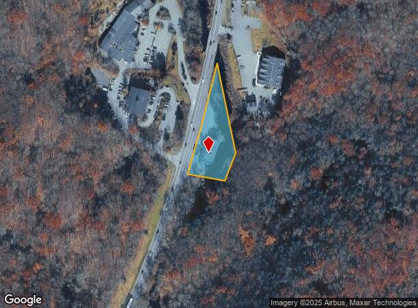
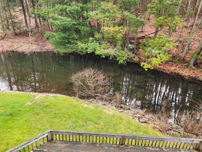
Property Record
529 Seven Bridge Rd, East Stroudsburg, PA 18301

NEARBY LISTINGS FOR SALE OR LEASE
Property Detail
529 Seven Bridge Rd
16.3.2.36-1
Lts Builders
Officebuilding
Monroe
AE
Pennsylvania
42089C0294E
1.06 AC
2025
Monroe County
2025
Philadelphia
300501
East Stroudsburg, PA
14,263 SF
DEMOGRAPHICS near 529 Seven Bridge Rd
1 Mile
3 Mile
5 Mile
2024 Total Population
1,175
14,033
35,417
2029 Population
1,175
13,711
34,828
Pop Growth 2024-2029
0.00%
(2.29%)
(1.66%)
Average Age
37
39
41
2024 Total Households
384
4,801
13,124
HH Growth 2024-2029
+ 1.30%
(1.87%)
(1.54%)
Median Household Inc
$92,884
$81,479
$79,349
Avg Household Size
2.50
2.50
2.50
2024 Avg HH Vehicles
2.00
2.00
2.00
Median Home Value
$277,999
$250,316
$244,194
Median Year Built
1985
1978
1979
Nearby Places
- Restaurants
- Banks
- Shops
- Fitness
- Groceries
PUBLIC TRANSPORTATION
AIRPORT
Lehigh Valley International
DRIVE
WALK
Distance
Lehigh Valley International
55 min
36.3 mi
Freight Ports
Maher Terminal
DRIVE
WALK
Distance
Maher Terminal
88 min
69.1 mi
SALE & LEASE HISTORY
LISTING DATE
SALE/LEASE

Sep 25, 2016
For Lease
Mar 28, 2019
For Lease
Mar 28, 2019
For Lease
Jun 06, 2022
For Sale
Nearby Properties
Address
Land Use
TOTAL SIZE
Lot Size
Zoning
Address
Land Use
TOTAL SIZE
Lot Size
Zoning
260,728 SF
23.15 AC
IU
Address
Land Use
TOTAL SIZE
Lot Size
Zoning
225,935 SF
3.74 AC
IM
Address
Land Use
TOTAL SIZE
Lot Size
Zoning
102,240 SF
34.13 AC
R-2
Address
Land Use
TOTAL SIZE
Lot Size
Zoning
254,320 SF
0.23 AC
IU
Address
Land Use
TOTAL SIZE
Lot Size
Zoning
16,664 SF
43.49 AC
R2
Address
Land Use
TOTAL SIZE
Lot Size
Zoning
198,124 SF
41.05 AC
R2
Address
Land Use
TOTAL SIZE
Lot Size
Zoning
91,431 SF
Address
Land Use
TOTAL SIZE
Lot Size
Zoning
112,582 SF
26.38 AC
B2
Address
Land Use
TOTAL SIZE
Lot Size
Zoning
4,769.70 AC
P
Address
Land Use
TOTAL SIZE
Lot Size
Zoning
129,257 SF
1.92 AC
IU
Address
Land Use
TOTAL SIZE
Lot Size
Zoning
126,740 SF
1.67 AC
IU
Address
Land Use
TOTAL SIZE
Lot Size
Zoning
90,072 SF
3.15 AC
IU
Address
Land Use
TOTAL SIZE
Lot Size
Zoning
47,427 SF
12.58 AC
C1
Address
Land Use
TOTAL SIZE
Lot Size
Zoning
20,984 SF
14.30 AC
I-E
Address
Land Use
TOTAL SIZE
Lot Size
Zoning
83,103 SF
30.80 AC
IU
Address
Land Use
TOTAL SIZE
Lot Size
Zoning
47,628 SF
4.40 AC
C1
Address
Land Use
TOTAL SIZE
Lot Size
Zoning
3,864 SF
195.93 AC
R1
Address
Land Use
TOTAL SIZE
Lot Size
Zoning
34,352 SF
9.83 AC
C1
Address
Land Use
TOTAL SIZE
Lot Size
Zoning
8,740 SF
9.25 AC
R-2
Address
Land Use
TOTAL SIZE
Lot Size
Zoning
30,622 SF
3.55 AC
C1
Address
Land Use
TOTAL SIZE
Lot Size
Zoning
72,774 SF
4.26 AC
R-1
Address
Land Use
TOTAL SIZE
Lot Size
Zoning
60,828 SF
1.18 AC
IU
Address
Land Use
TOTAL SIZE
Lot Size
Zoning
97,438 SF
2.27 AC
IM
Address
Land Use
TOTAL SIZE
Lot Size
Zoning
68,640 SF
0.17 AC
IU
Address
Land Use
TOTAL SIZE
Lot Size
Zoning
31,978 SF
18.89 AC
IU
Address
Land Use
TOTAL SIZE
Lot Size
Zoning
67,584 SF
1.98 AC
IU
Address
Land Use
TOTAL SIZE
Lot Size
Zoning
6,417 SF
22.47 AC
C-2
Address
Land Use
TOTAL SIZE
Lot Size
Zoning
21,612 SF
3.70 AC
C1
Address
Land Use
TOTAL SIZE
Lot Size
Zoning
48,309 SF
6.90 AC
R1
Address
Land Use
TOTAL SIZE
Lot Size
Zoning
1,581 SF
21.64 AC
R1
The World's #1 Commercial Real Estate Marketplace
Connect with us
© 2025 CoStar Group
The information above has been obtained from sources believed reliable. While we do not doubt its accuracy we have not verified it and make no guarantee, warranty or representation about it. It is your responsibility to independently confirm its accuracy and completeness. Any projections, opinions, assumptions, or estimates used are for example only and do not represent the current or future performance of the property. The value of this transaction to you depends on tax and other factors which should be evaluated by your tax, financial, and legal advisors. You and your advisors should conduct a careful, independent investigation of the property to determine to your satisfaction the suitability of the property for your needs.