Property Record
5290 Manchester Rd, New Franklin, OH 44319


NEARBY LISTINGS FOR SALE OR LEASE
-
-
View all New Franklin listings for sale on LoopNet.com
Property Detail
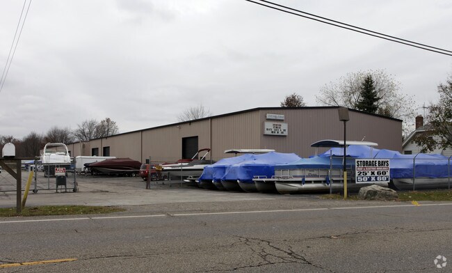
5290 Manchester Rd
Akron, OH
Situated
23-04529
TR 14 LOT SW OF MANCHESTER RD 181.32FF 6.9731A
Commercialnec
Summit
X
Ohio
39153C0254E
sw
2023
6.97 AC
2025
Akron
531702
Cleveland
21,000 SF
DEMOGRAPHICS near 5290 Manchester Rd
1 Mile
3 Mile
5 Mile
2024 Total Population
2,717
17,625
71,085
2029 Population
2,675
17,364
70,275
Pop Growth 2024-2029
(1.55%)
(1.48%)
(1.14%)
Average Age
44
45
43
2024 Total Households
1,095
7,450
30,249
HH Growth 2024-2029
(1.46%)
(1.44%)
(1.16%)
Median Household Inc
$77,500
$83,928
$64,365
Avg Household Size
2.40
2.30
2.30
2024 Avg HH Vehicles
2.00
2.00
2.00
Median Home Value
$173,779
$197,704
$169,465
Median Year Built
1961
1964
1965
Nearby Places
Map Layers
Map Styles
 Street
 Aerial
- Restaurants
- Banks
- Shops
- Fitness
- Groceries
PUBLIC TRANSPORTATION
AIRPORT
Akron-Canton Regional
DRIVE
WALK
Distance
Akron-Canton Regional
20 min
9.8 mi
Cleveland-Hopkins International
DRIVE
WALK
Distance
Cleveland-Hopkins International
68 min
46.5 mi
Nearby Properties
Address
Land Use
TOTAL SIZE
Lot Size
Zoning
Address
Land Use
TOTAL SIZE
Lot Size
Zoning
Address
Land Use
TOTAL SIZE
Lot Size
Zoning
1,049.17 AC
Address
Land Use
TOTAL SIZE
Lot Size
Zoning
Address
Land Use
TOTAL SIZE
Lot Size
Zoning
Address
Land Use
TOTAL SIZE
Lot Size
Zoning
Address
Land Use
TOTAL SIZE
Lot Size
Zoning
24,812 SF
29.15 AC
Address
Land Use
TOTAL SIZE
Lot Size
Zoning
Address
Land Use
TOTAL SIZE
Lot Size
Zoning
Address
Land Use
TOTAL SIZE
Lot Size
Zoning
136,491 SF
35.31 AC
Address
Land Use
TOTAL SIZE
Lot Size
Zoning
Address
Land Use
TOTAL SIZE
Lot Size
Zoning
Address
Land Use
TOTAL SIZE
Lot Size
Zoning
Address
Land Use
TOTAL SIZE
Lot Size
Zoning
4,800 SF
493 AC
Address
Land Use
TOTAL SIZE
Lot Size
Zoning
Address
Land Use
TOTAL SIZE
Lot Size
Zoning
70,783 SF
15.97 AC
Address
Land Use
TOTAL SIZE
Lot Size
Zoning
47,384 SF
30.16 AC
Address
Land Use
TOTAL SIZE
Lot Size
Zoning
62,000 SF
6.91 AC
Address
Land Use
TOTAL SIZE
Lot Size
Zoning
Address
Land Use
TOTAL SIZE
Lot Size
Zoning
Address
Land Use
TOTAL SIZE
Lot Size
Zoning
Address
Land Use
TOTAL SIZE
Lot Size
Zoning
16,346 SF
12.13 AC
Address
Land Use
TOTAL SIZE
Lot Size
Zoning
38,078 SF
6.15 AC
Address
Land Use
TOTAL SIZE
Lot Size
Zoning
39,266 SF
21.17 AC
Address
Land Use
TOTAL SIZE
Lot Size
Zoning
Address
Land Use
TOTAL SIZE
Lot Size
Zoning
78,543 SF
6.34 AC
Address
Land Use
TOTAL SIZE
Lot Size
Zoning
65,600 SF
13.17 AC
Address
Land Use
TOTAL SIZE
Lot Size
Zoning
41,419 SF
2.03 AC
Address
Land Use
TOTAL SIZE
Lot Size
Zoning
22,478 SF
8.50 AC
Address
Land Use
TOTAL SIZE
Lot Size
Zoning
8.68 AC
Address
Land Use
TOTAL SIZE
Lot Size
Zoning
25,264 SF
8.60 AC
The World's #1 Commercial Real Estate Marketplace
Connect with us
© 2025 CoStar Group
The information above has been obtained from sources believed reliable. While we do not doubt its accuracy we have not verified it and make no guarantee, warranty or representation about it. It is your responsibility to independently confirm its accuracy and completeness. Any projections, opinions, assumptions, or estimates used are for example only and do not represent the current or future performance of the property. The value of this transaction to you depends on tax and other factors which should be evaluated by your tax, financial, and legal advisors. You and your advisors should conduct a careful, independent investigation of the property to determine to your satisfaction the suitability of the property for your needs.