Property Record
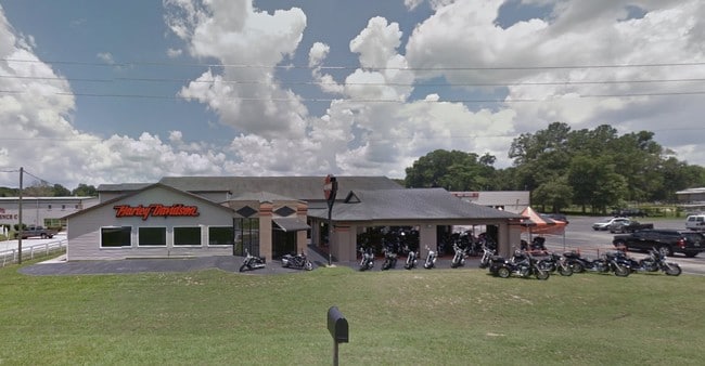
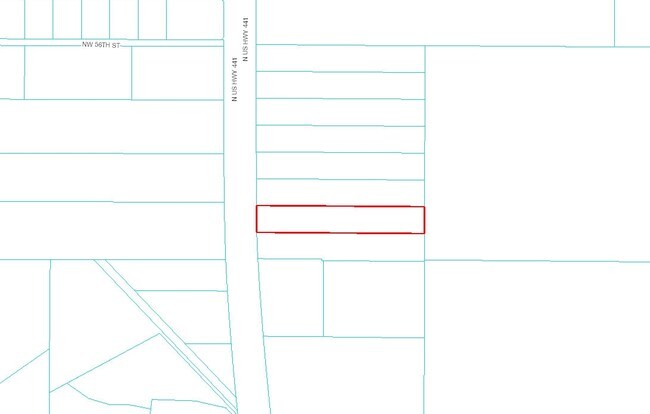
5295 N Us Highway 441, Ocala, FL 34475
NEARBY LISTINGS FOR SALE OR LEASE
Property Detail
5295 N Us Highway 441
15236-000-00
SEC 30 TWP 14 RGE 22 S 1/8 OF NW 1/4 OF SW 1/4 EX S 9.9 FT OF E 630 FT & EX SR 25-A R/WAY
Vehiclerentalsvehiclesales
Marion
X
Florida
12083C0507D
3.80 AC
2024
Outlying Marion County
2024
Ocala
001301
Ocala, FL
24,800 SF
DEMOGRAPHICS near 5295 N Us Highway 441
1 Mile
3 Mile
5 Mile
2024 Total Population
2,316
19,428
63,991
2029 Population
2,622
21,925
72,075
Pop Growth 2024-2029
+ 13.21%
+ 12.85%
+ 12.63%
Average Age
39
39
41
2024 Total Households
922
7,555
25,431
HH Growth 2024-2029
+ 13.23%
+ 12.83%
+ 12.82%
Median Household Inc
$39,033
$42,683
$44,769
Avg Household Size
2.40
2.50
2.30
2024 Avg HH Vehicles
2.00
2.00
2.00
Median Home Value
$208,765
$181,498
$168,759
Median Year Built
1986
1983
1983
Nearby Places
Map Layers
Map Styles
 Street
 Aerial
- Restaurants
- Banks
- Shops
- Fitness
- Groceries
Nearby Properties
Address
Land Use
TOTAL SIZE
Lot Size
Zoning
Address
Land Use
TOTAL SIZE
Lot Size
Zoning
1,085,670 SF
89.70 AC
M1
Address
Land Use
TOTAL SIZE
Lot Size
Zoning
612,196 SF
50.06 AC
M1
Address
Land Use
TOTAL SIZE
Lot Size
Zoning
617,520 SF
46.08 AC
M2
Address
Land Use
TOTAL SIZE
Lot Size
Zoning
441,040 SF
150.01 AC
M1
Address
Land Use
TOTAL SIZE
Lot Size
Zoning
458,983 SF
35.14 AC
M1
Address
Land Use
TOTAL SIZE
Lot Size
Zoning
444,381 SF
60 AC
M1
Address
Land Use
TOTAL SIZE
Lot Size
Zoning
350,895 SF
27.85 AC
M1
Address
Land Use
TOTAL SIZE
Lot Size
Zoning
140,920 SF
28.09 AC
M2
Address
Land Use
TOTAL SIZE
Lot Size
Zoning
29,068 SF
22.30 AC
PD
Address
Land Use
TOTAL SIZE
Lot Size
Zoning
112,663 SF
32.72 AC
INST
Address
Land Use
TOTAL SIZE
Lot Size
Zoning
384,930 SF
17.76 AC
M1
Address
Land Use
TOTAL SIZE
Lot Size
Zoning
64,438 SF
12.27 AC
B4
Address
Land Use
TOTAL SIZE
Lot Size
Zoning
116,876 SF
23.78 AC
M2
Address
Land Use
TOTAL SIZE
Lot Size
Zoning
73,361 SF
23.20 AC
GU
Address
Land Use
TOTAL SIZE
Lot Size
Zoning
55,809 SF
6.30 AC
M2
Address
Land Use
TOTAL SIZE
Lot Size
Zoning
47,984 SF
448.37 AC
PUD
Address
Land Use
TOTAL SIZE
Lot Size
Zoning
66,531 SF
26.96 AC
B2
Address
Land Use
TOTAL SIZE
Lot Size
Zoning
30,082 SF
7.92 AC
PUD
Address
Land Use
TOTAL SIZE
Lot Size
Zoning
176,710 SF
11.88 AC
M1
Address
Land Use
TOTAL SIZE
Lot Size
Zoning
44,100 SF
9.60 AC
R3
Address
Land Use
TOTAL SIZE
Lot Size
Zoning
Address
Land Use
TOTAL SIZE
Lot Size
Zoning
79,249 SF
14.46 AC
R3
Address
Land Use
TOTAL SIZE
Lot Size
Zoning
89,640 SF
33.21 AC
B5
Address
Land Use
TOTAL SIZE
Lot Size
Zoning
72,855 SF
47.31 AC
B2
Address
Land Use
TOTAL SIZE
Lot Size
Zoning
39,979 SF
24.28 AC
GU
Address
Land Use
TOTAL SIZE
Lot Size
Zoning
28,980 SF
16 AC
A1
Address
Land Use
TOTAL SIZE
Lot Size
Zoning
42,901 SF
17.03 AC
GU
Address
Land Use
TOTAL SIZE
Lot Size
Zoning
57,558 SF
9.18 AC
B4
Address
Land Use
TOTAL SIZE
Lot Size
Zoning
36,888 SF
4.81 AC
R3
Address
Land Use
TOTAL SIZE
Lot Size
Zoning
7,348 SF
3.52 AC
GU
The World's #1 Commercial Real Estate Marketplace
Connect with us
© 2025 CoStar Group
The information above has been obtained from sources believed reliable. While we do not doubt its accuracy we have not verified it and make no guarantee, warranty or representation about it. It is your responsibility to independently confirm its accuracy and completeness. Any projections, opinions, assumptions, or estimates used are for example only and do not represent the current or future performance of the property. The value of this transaction to you depends on tax and other factors which should be evaluated by your tax, financial, and legal advisors. You and your advisors should conduct a careful, independent investigation of the property to determine to your satisfaction the suitability of the property for your needs.