Property Record
5299 W Highway 29, Georgetown, TX 78628
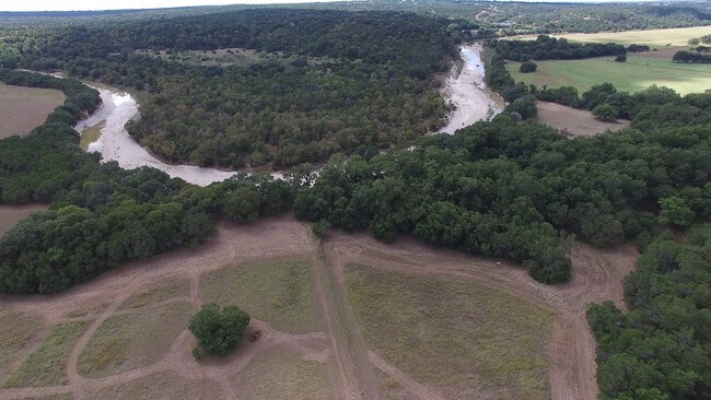


Property Detail
5299 W Highway 29
R602875
AW0178 AW0178 - DONAGAN, I. SUR., ACRES 53.724
Agriculturalland
WILLIAMSON
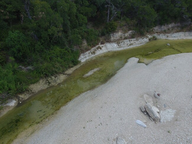
B and X Area of moderate flood hazard, usually the area between the limits of the 100-year and 500-year floods.
Texas
2024
53.72 AC
2025
Georgetown
020121
Austin
12,231 SF
Austin-Round Rock-San Marcos, TX
NEARBY LISTINGS FOR SALE OR LEASE
DEMOGRAPHICS near 5299 W Highway 29
1 mile
3 mile
5 mile
2024 Total Population
2,911
15,880
55,549
2029 Population
3,874
20,879
71,813
Pop Growth 2024-2029
+ 33.08%
+ 31.48%
+ 29.28%
Average Age
46
40
39
2024 Total Households
1,105
5,577
19,970
HH Growth 2024-2029
+ 33.57%
+ 31.97%
+ 29.90%
Median Household Inc
$157,068
$164,134
$136,162
Avg Household Size
2.60
2.80
2.80
2024 Avg HH Vehicles
2.00
2.00
2.00
Median Home Value
$675,203
$590,869
$516,306
Median Year Built
2011
2011
2011
Nearby Places
Map Layers
Map Styles
 Street
 Aerial
Transit
 Traffic
 Biking
Places
Listings with unknown addresses are not visible on the map
- Restaurants
- Banks
- Shops
- Fitness
- Groceries
PUBLIC TRANSPORTATION
COMMUTER RAIL
Leander Station (Capital MetroRail - Capital Metropolitan Transportation Authority Rail (MetroRail))
Drive
Walk
Distance
Leander Station (Capital MetroRail - Capital Metropolitan Transportation Authority Rail (MetroRail))
12 min
9.7 mi
Freight Ports
Calhoun Port
Drive
Walk
Distance
Calhoun Port
1 min
153.9 mi
SALE & LEASE HISTORY
LISTING DATE
SALE/LEASE

Oct 02, 2019
For Sale
Apr 17, 2020
For Sale
Nearby Properties
Address
Land Use
TOTAL SIZE
Lot Size
Zoning
Address
Land Use
TOTAL SIZE
Lot Size
Zoning
393,202 SF
15.42 AC
Address
Land Use
TOTAL SIZE
Lot Size
Zoning
109,663 SF
19.54 AC
Address
Land Use
TOTAL SIZE
Lot Size
Zoning
11.98 AC
Address
Land Use
TOTAL SIZE
Lot Size
Zoning
40,042 SF
19.78 AC
Address
Land Use
TOTAL SIZE
Lot Size
Zoning
53,794 SF
19.77 AC
Address
Land Use
TOTAL SIZE
Lot Size
Zoning
125,929 SF
2.18 AC
Address
Land Use
TOTAL SIZE
Lot Size
Zoning
90,802 SF
10.36 AC
Address
Land Use
TOTAL SIZE
Lot Size
Zoning
72,199 SF
7.85 AC
Address
Land Use
TOTAL SIZE
Lot Size
Zoning
177,611 SF
6.42 AC
Address
Land Use
TOTAL SIZE
Lot Size
Zoning
32,092 SF
0.14 AC
Address
Land Use
TOTAL SIZE
Lot Size
Zoning
61,130 SF
7.71 AC
Address
Land Use
TOTAL SIZE
Lot Size
Zoning
89.42 AC
Address
Land Use
TOTAL SIZE
Lot Size
Zoning
12,774 SF
1.73 AC
Address
Land Use
TOTAL SIZE
Lot Size
Zoning
1,508 SF
7.01 AC
Address
Land Use
TOTAL SIZE
Lot Size
Zoning
17,032 SF
3.65 AC
Address
Land Use
TOTAL SIZE
Lot Size
Zoning
3,237 SF
81.23 AC
Address
Land Use
TOTAL SIZE
Lot Size
Zoning
5,242 SF
1.89 AC
Address
Land Use
TOTAL SIZE
Lot Size
Zoning
7,175 SF
2.20 AC
Address
Land Use
TOTAL SIZE
Lot Size
Zoning
7,180 SF
4.72 AC
Address
Land Use
TOTAL SIZE
Lot Size
Zoning
34.51 AC
Address
Land Use
TOTAL SIZE
Lot Size
Zoning
13,710 SF
3.65 AC
Address
Land Use
TOTAL SIZE
Lot Size
Zoning
4,698 SF
1.50 AC
Address
Land Use
TOTAL SIZE
Lot Size
Zoning
14,614 SF
33.52 AC
Address
Land Use
TOTAL SIZE
Lot Size
Zoning
32,092 SF
14.05 AC
Address
Land Use
TOTAL SIZE
Lot Size
Zoning
11,000 SF
2 AC
Address
Land Use
TOTAL SIZE
Lot Size
Zoning
5,151 SF
2.61 AC
Address
Land Use
TOTAL SIZE
Lot Size
Zoning
17,426 SF
2.46 AC
Address
Land Use
TOTAL SIZE
Lot Size
Zoning
10.02 AC
Address
Land Use
TOTAL SIZE
Lot Size
Zoning
Address
Land Use
TOTAL SIZE
Lot Size
Zoning
The World's #1 Commercial Real Estate Marketplace
Connect with us
© 2026 CoStar Group
The information above has been obtained from sources believed reliable. While we do not doubt its accuracy we have not verified it and make no guarantee, warranty or representation about it. It is your responsibility to independently confirm its accuracy and completeness. Any projections, opinions, assumptions, or estimates used are for example only and do not represent the current or future performance of the property. The value of this transaction to you depends on tax and other factors which should be evaluated by your tax, financial, and legal advisors. You and your advisors should conduct a careful, independent investigation of the property to determine to your satisfaction the suitability of the property for your needs.