Property Record
52Nd St, Kenosha, WI 53144

Property Detail
52Nd St
Kenosha, WI
LOT 2 OF SHOPKO KENOSHA SUB PT OF SW 1/4 OF NW 1/4 SEC 35 T2 R22 DOC#1465228 PLAT #6405 (2006 PT 08-222-35-251-004) DOC#14684
08-222-35-251-012
KENOSHA
Commercialacreage
Wisconsin
B2
2
B and X Area of moderate flood hazard, usually the area between the limits of the 100-year and 500-year floods.
0.50 AC
2025
Kenosha East
2025
Chicago
000603
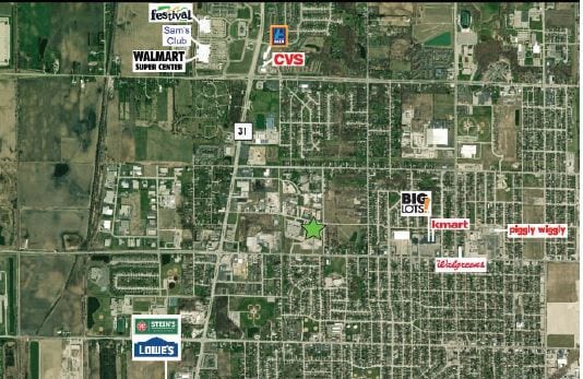
NEARBY LISTINGS FOR SALE OR LEASE
DEMOGRAPHICS near 52Nd St
1 mile
3 mile
5 mile
2025 Total Population
11,556
80,088
118,603
2030 Population
11,515
79,109
117,754
Pop Growth 2025-2030
(0.35%)
(1.22%)
(0.72%)
Average Age
38
39
40
2025 Total Households
4,276
31,303
47,103
HH Growth 2025-2030
(0.44%)
(1.21%)
(0.71%)
Median Household Inc
$66,475
$66,724
$70,287
Avg Household Size
2.60
2.40
2.40
2025 Avg HH Vehicles
2.00
2.00
2.00
Median Home Value
$206,462
$221,657
$248,263
Median Year Built
1970
1965
1972
Nearby Places
Map Layers
Map Styles
 Street
 Aerial
Layers
 Traffic
 Biking
Places
Listings with unknown addresses are not visible on the map
- Restaurants
- Banks
- Shops
- Fitness
- Groceries
PUBLIC TRANSPORTATION
COMMUTER RAIL
Kenosha Station (Union Pacific North Line - Northeast Illinois Regional Commuter Railroad (Metra))
Drive
Walk
Distance
Kenosha Station (Union Pacific North Line - Northeast Illinois Regional Commuter Railroad (Metra))
8 min
2.8 mi
AIRPORT
General Mitchell International
Drive
Walk
Distance
General Mitchell International
39 min
30.7 mi
Freight Ports
Port Milwaukee
Drive
Walk
Distance
Port Milwaukee
44 min
34.5 mi
SALE & LEASE HISTORY
LISTING DATE
SALE/LEASE

Sep 28, 2021
For Sale
Sep 24, 2016
For Sale
Oct 24, 2016
For Sale
Nov 01, 2016
For Sale
Mar 10, 2020
For Sale
Dec 30, 2016
For Sale
Nearby Properties
Address
Land Use
TOTAL SIZE
Lot Size
Zoning
Address
Land Use
TOTAL SIZE
Lot Size
Zoning
731,186 SF
81.94 AC
M2
Address
Land Use
TOTAL SIZE
Lot Size
Zoning
3,886 SF
20.04 AC
Address
Land Use
TOTAL SIZE
Lot Size
Zoning
850,230 SF
39.46 AC
M2
Address
Land Use
TOTAL SIZE
Lot Size
Zoning
763,999 SF
57.67 AC
FW
Address
Land Use
TOTAL SIZE
Lot Size
Zoning
602,348 SF
36.02 AC
Address
Land Use
TOTAL SIZE
Lot Size
Zoning
601,439 SF
32.10 AC
Address
Land Use
TOTAL SIZE
Lot Size
Zoning
10.37 AC
IP
Address
Land Use
TOTAL SIZE
Lot Size
Zoning
35,092 SF
26.34 AC
B2
Address
Land Use
TOTAL SIZE
Lot Size
Zoning
357,885 SF
26.58 AC
M1
Address
Land Use
TOTAL SIZE
Lot Size
Zoning
3,721 SF
24.57 AC
FW
Address
Land Use
TOTAL SIZE
Lot Size
Zoning
26,016 SF
14.02 AC
FW
Address
Land Use
TOTAL SIZE
Lot Size
Zoning
451,022 SF
30.04 AC
Address
Land Use
TOTAL SIZE
Lot Size
Zoning
52,016 SF
25.40 AC
FW
Address
Land Use
TOTAL SIZE
Lot Size
Zoning
194,281 SF
19.13 AC
B2
Address
Land Use
TOTAL SIZE
Lot Size
Zoning
85,847 SF
5.03 AC
RM2
Address
Land Use
TOTAL SIZE
Lot Size
Zoning
4,643 SF
60 AC
Address
Land Use
TOTAL SIZE
Lot Size
Zoning
109,526 SF
6.61 AC
M2
Address
Land Use
TOTAL SIZE
Lot Size
Zoning
32,245 SF
22 AC
RM2
Address
Land Use
TOTAL SIZE
Lot Size
Zoning
279,872 SF
14.60 AC
M2
Address
Land Use
TOTAL SIZE
Lot Size
Zoning
183,173 SF
9.73 AC
RM3
Address
Land Use
TOTAL SIZE
Lot Size
Zoning
26.05 AC
Address
Land Use
TOTAL SIZE
Lot Size
Zoning
14.40 AC
Address
Land Use
TOTAL SIZE
Lot Size
Zoning
2,963 SF
13.16 AC
Address
Land Use
TOTAL SIZE
Lot Size
Zoning
148,330 SF
17.55 AC
Address
Land Use
TOTAL SIZE
Lot Size
Zoning
270,195 SF
13.66 AC
M2
Address
Land Use
TOTAL SIZE
Lot Size
Zoning
7,830 SF
16 AC
FW
Address
Land Use
TOTAL SIZE
Lot Size
Zoning
85,469 SF
11.30 AC
Address
Land Use
TOTAL SIZE
Lot Size
Zoning
176,978 SF
24.81 AC
Address
Land Use
TOTAL SIZE
Lot Size
Zoning
31,650 SF
7.62 AC
FW
Address
Land Use
TOTAL SIZE
Lot Size
Zoning
147,040 SF
2.50 AC
RM2
The World's #1 Commercial Real Estate Marketplace
Connect with us
© 2026 CoStar Group
The information above has been obtained from sources believed reliable. While we do not doubt its accuracy we have not verified it and make no guarantee, warranty or representation about it. It is your responsibility to independently confirm its accuracy and completeness. Any projections, opinions, assumptions, or estimates used are for example only and do not represent the current or future performance of the property. The value of this transaction to you depends on tax and other factors which should be evaluated by your tax, financial, and legal advisors. You and your advisors should conduct a careful, independent investigation of the property to determine to your satisfaction the suitability of the property for your needs.