Property Record
52Nd St, Salome, AZ 85348
Property Detail
52Nd St
303-72-020A
SECTION: 26 TOWNSHIP: 3N RANGE: 11W THAT PORTION OF THE SE4 SEC 26 3N 11W COMM AT NE COR SE4 S26 THN W 33 TPOB THN S 210 THN W 210 THN N 210 THN E 210 TPOB SHOWN AS PARCEL 1 ON SURVEY 2012-2526
Vacantlandnec
LA PAZ
B and X Area of moderate flood hazard, usually the area between the limits of the 100-year and 500-year floods.
Arizona
2023
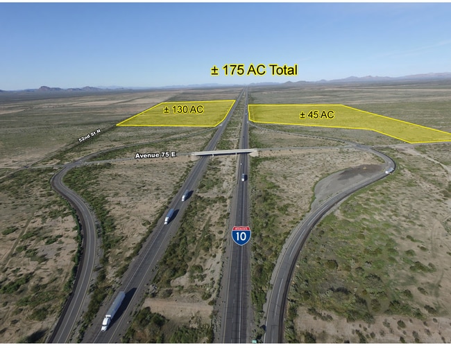
92.61 AC
2026
Yuma & El Centro
020501
Other Market Areas
NEARBY LISTINGS FOR SALE OR LEASE
-
-
View all Salome listings for sale on LoopNet.com
DEMOGRAPHICS near 52Nd St
1 mile
3 mile
5 mile
2025 Total Population
0
0
2
2030 Population
0
0
2
Pop Growth 2025-2030
0.00%
0.00%
0.00%
Average Age
0
0
0
2025 Total Households
0
0
1
HH Growth 2025-2030
0.00%
0.00%
0.00%
Median Household Inc
$0
$0
$0
Avg Household Size
.00
.00
.00
2025 Avg HH Vehicles
.00
.00
.00
Median Home Value
$0
$0
$0
Median Year Built
0
0
0
Nearby Places
Map Layers
Map Styles
 Street
 Aerial
Layers
 Traffic
 Biking
Places
Listings with unknown addresses are not visible on the map
- Restaurants
- Banks
- Shops
- Fitness
- Groceries
SALE & LEASE HISTORY
LISTING DATE
SALE/LEASE

Apr 01, 2020
For Sale
Nearby Properties
Address
Land Use
TOTAL SIZE
Lot Size
Zoning
Address
Land Use
TOTAL SIZE
Lot Size
Zoning
240 AC
Address
Land Use
TOTAL SIZE
Lot Size
Zoning
197.99 AC
Address
Land Use
TOTAL SIZE
Lot Size
Zoning
185.61 AC
Address
Land Use
TOTAL SIZE
Lot Size
Zoning
160 AC
Address
Land Use
TOTAL SIZE
Lot Size
Zoning
158 AC
Address
Land Use
TOTAL SIZE
Lot Size
Zoning
110.02 AC
Address
Land Use
TOTAL SIZE
Lot Size
Zoning
98.75 AC
Address
Land Use
TOTAL SIZE
Lot Size
Zoning
Address
Land Use
TOTAL SIZE
Lot Size
Zoning
Address
Land Use
TOTAL SIZE
Lot Size
Zoning
Address
Land Use
TOTAL SIZE
Lot Size
Zoning
Address
Land Use
TOTAL SIZE
Lot Size
Zoning
Address
Land Use
TOTAL SIZE
Lot Size
Zoning
17.08 AC
Address
Land Use
TOTAL SIZE
Lot Size
Zoning
69.09 AC
Address
Land Use
TOTAL SIZE
Lot Size
Zoning
59.25 AC
Address
Land Use
TOTAL SIZE
Lot Size
Zoning
39.50 AC
Address
Land Use
TOTAL SIZE
Lot Size
Zoning
39.50 AC
Address
Land Use
TOTAL SIZE
Lot Size
Zoning
39.50 AC
Address
Land Use
TOTAL SIZE
Lot Size
Zoning
35.79 AC
Address
Land Use
TOTAL SIZE
Lot Size
Zoning
Address
Land Use
TOTAL SIZE
Lot Size
Zoning
Address
Land Use
TOTAL SIZE
Lot Size
Zoning
Address
Land Use
TOTAL SIZE
Lot Size
Zoning
Address
Land Use
TOTAL SIZE
Lot Size
Zoning
16.26 AC
Address
Land Use
TOTAL SIZE
Lot Size
Zoning
15.94 AC
Address
Land Use
TOTAL SIZE
Lot Size
Zoning
12.92 AC
Address
Land Use
TOTAL SIZE
Lot Size
Zoning
23.24 AC
Address
Land Use
TOTAL SIZE
Lot Size
Zoning
12.11 AC
The World's #1 Commercial Real Estate Marketplace
Connect with us
© 2026 CoStar Group
The information above has been obtained from sources believed reliable. While we do not doubt its accuracy we have not verified it and make no guarantee, warranty or representation about it. It is your responsibility to independently confirm its accuracy and completeness. Any projections, opinions, assumptions, or estimates used are for example only and do not represent the current or future performance of the property. The value of this transaction to you depends on tax and other factors which should be evaluated by your tax, financial, and legal advisors. You and your advisors should conduct a careful, independent investigation of the property to determine to your satisfaction the suitability of the property for your needs.