Property Record
53 Chestnut Hill Rd, Wolcott, CT 06716

Property Detail
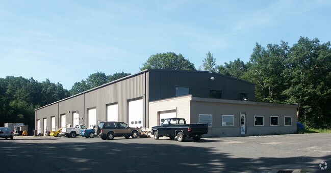
53 Chestnut Hill Rd
PROS-000105-000156-000103
New Haven
Parkingstructure
Connecticut
B
103
B and X Area of moderate flood hazard, usually the area between the limits of the 100-year and 500-year floods.
2.94 AC
2025
Cheshire
2025
Westchester/So Connecticut
347100
New Haven, CT
12,720 SF
NEARBY LISTINGS FOR SALE OR LEASE
DEMOGRAPHICS near 53 Chestnut Hill Rd
1 mile
3 mile
5 mile
2025 Total Population
3,273
45,777
149,746
2030 Population
3,377
46,786
153,313
Pop Growth 2025-2030
+ 3.18%
+ 2.20%
+ 2.38%
Average Age
43
41
40
2025 Total Households
1,205
17,725
58,633
HH Growth 2025-2030
+ 3.07%
+ 2.17%
+ 2.42%
Median Household Inc
$124,431
$76,953
$66,186
Avg Household Size
2.70
2.50
2.50
2025 Avg HH Vehicles
2.00
2.00
2.00
Median Home Value
$377,631
$273,727
$276,444
Median Year Built
1978
1968
1962
Nearby Places
Map Layers
Map Styles
 Street
 Aerial
Layers
 Traffic
 Biking
Places
Listings with unknown addresses are not visible on the map
- Restaurants
- Banks
- Shops
- Fitness
- Groceries
PUBLIC TRANSPORTATION
COMMUTER RAIL
Waterbury Station (New Haven Line - Metro-North Commuter Railroad Company (Metro-North))
Drive
Walk
Distance
Waterbury Station (New Haven Line - Metro-North Commuter Railroad Company (Metro-North))
10 min
3.8 mi
Naugatuck Station (New Haven Line - Metro-North Commuter Railroad Company (Metro-North))
Drive
Walk
Distance
Naugatuck Station (New Haven Line - Metro-North Commuter Railroad Company (Metro-North))
16 min
8.1 mi
AIRPORT
Tweed/New Haven
Drive
Walk
Distance
Tweed/New Haven
52 min
30.8 mi
Bradley International
Drive
Walk
Distance
Bradley International
70 min
38.8 mi
Freight Ports
Port of New Haven
Drive
Walk
Distance
Port of New Haven
47 min
28.5 mi
Nearby Properties
Address
Land Use
TOTAL SIZE
Lot Size
Zoning
Address
Land Use
TOTAL SIZE
Lot Size
Zoning
306,366 SF
84 AC
RS-12
Address
Land Use
TOTAL SIZE
Lot Size
Zoning
196,057 SF
17 AC
RS
Address
Land Use
TOTAL SIZE
Lot Size
Zoning
195,000 SF
1.41 AC
CBD
Address
Land Use
TOTAL SIZE
Lot Size
Zoning
1.86 AC
CBD
Address
Land Use
TOTAL SIZE
Lot Size
Zoning
1.30 AC
CBD
Address
Land Use
TOTAL SIZE
Lot Size
Zoning
97,695 SF
0.57 AC
CBD
Address
Land Use
TOTAL SIZE
Lot Size
Zoning
118,884 SF
13.40 AC
RL
Address
Land Use
TOTAL SIZE
Lot Size
Zoning
70,857 SF
1.71 AC
CBD
Address
Land Use
TOTAL SIZE
Lot Size
Zoning
129,672 SF
8 AC
IG
Address
Land Use
TOTAL SIZE
Lot Size
Zoning
103,254 SF
2.03 AC
CBD
Address
Land Use
TOTAL SIZE
Lot Size
Zoning
44.31 AC
CA
Address
Land Use
TOTAL SIZE
Lot Size
Zoning
54,580 SF
0.65 AC
CBD
Address
Land Use
TOTAL SIZE
Lot Size
Zoning
45,605 SF
2.48 AC
RH
Address
Land Use
TOTAL SIZE
Lot Size
Zoning
95,000 SF
9.30 AC
RM
Address
Land Use
TOTAL SIZE
Lot Size
Zoning
5.13 AC
RM
Address
Land Use
TOTAL SIZE
Lot Size
Zoning
39 AC
RM
Address
Land Use
TOTAL SIZE
Lot Size
Zoning
19.24 AC
CA
Address
Land Use
TOTAL SIZE
Lot Size
Zoning
35,860 SF
1.29 AC
CBD
Address
Land Use
TOTAL SIZE
Lot Size
Zoning
419,566 SF
0.35 AC
CBD
Address
Land Use
TOTAL SIZE
Lot Size
Zoning
50 AC
R-40
Address
Land Use
TOTAL SIZE
Lot Size
Zoning
56,580 SF
1.13 AC
CBD
Address
Land Use
TOTAL SIZE
Lot Size
Zoning
24.49 AC
CA
Address
Land Use
TOTAL SIZE
Lot Size
Zoning
31.75 AC
CA
Address
Land Use
TOTAL SIZE
Lot Size
Zoning
18.01 AC
CA
Address
Land Use
TOTAL SIZE
Lot Size
Zoning
10.51 AC
RL
Address
Land Use
TOTAL SIZE
Lot Size
Zoning
74,579 SF
1.02 AC
CBD
Address
Land Use
TOTAL SIZE
Lot Size
Zoning
15.39 AC
RM
Address
Land Use
TOTAL SIZE
Lot Size
Zoning
167,266 SF
1.85 AC
CBD
Address
Land Use
TOTAL SIZE
Lot Size
Zoning
1.30 AC
CBD
Address
Land Use
TOTAL SIZE
Lot Size
Zoning
30.46 AC
RM
The World's #1 Commercial Real Estate Marketplace
Connect with us
© 2026 CoStar Group
The information above has been obtained from sources believed reliable. While we do not doubt its accuracy we have not verified it and make no guarantee, warranty or representation about it. It is your responsibility to independently confirm its accuracy and completeness. Any projections, opinions, assumptions, or estimates used are for example only and do not represent the current or future performance of the property. The value of this transaction to you depends on tax and other factors which should be evaluated by your tax, financial, and legal advisors. You and your advisors should conduct a careful, independent investigation of the property to determine to your satisfaction the suitability of the property for your needs.