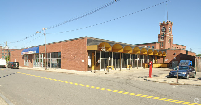
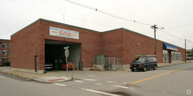
Property Record
53 High St, Milford, NH 03055
Current Lease Availabilities
NEARBY LISTINGS FOR SALE OR LEASE
Property Detail
53 High St
MFRD-000026-000000-000135
Hillsborough
Triplex
New Hampshire
X
98
33011C0459D
0.14 AC
2024
Hillsborough
2024
Boston
010700
Manchester-Nashua, NH
2,340 SF
DEMOGRAPHICS near 53 High St
1 Mile
3 Mile
5 Mile
2024 Total Population
24,354
83,592
123,539
2029 Population
24,765
85,245
126,190
Pop Growth 2024-2029
+ 1.69%
+ 1.98%
+ 2.15%
Average Age
38
42
42
2024 Total Households
10,428
34,250
50,814
HH Growth 2024-2029
+ 1.74%
+ 2.00%
+ 2.17%
Median Household Inc
$53,432
$86,350
$93,024
Avg Household Size
2.20
2.40
2.40
2024 Avg HH Vehicles
1.00
2.00
2.00
Median Home Value
$297,739
$350,885
$365,502
Median Year Built
1947
1970
1977
Nearby Places
- Restaurants
- Banks
- Shops
- Fitness
- Groceries
PUBLIC TRANSPORTATION
AIRPORT
Manchester Boston Regional
DRIVE
WALK
Distance
Manchester Boston Regional
34 min
18.5 mi
Freight Ports
Port of Boston
DRIVE
WALK
Distance
Port of Boston
86 min
59.4 mi
Nearby Properties
Address
Land Use
TOTAL SIZE
Lot Size
Zoning
Address
Land Use
TOTAL SIZE
Lot Size
Zoning
165,257 SF
9.25 AC
A
Address
Land Use
TOTAL SIZE
Lot Size
Zoning
109,431 SF
44.60 AC
R
Address
Land Use
TOTAL SIZE
Lot Size
Zoning
29,952 SF
12.50 AC
B
Address
Land Use
TOTAL SIZE
Lot Size
Zoning
102,843 SF
26.32 AC
A
Address
Land Use
TOTAL SIZE
Lot Size
Zoning
19,968 SF
5.91 AC
B
Address
Land Use
TOTAL SIZE
Lot Size
Zoning
2,124 SF
4.80 AC
C
Address
Land Use
TOTAL SIZE
Lot Size
Zoning
15,616 SF
6.06 AC
B
Address
Land Use
TOTAL SIZE
Lot Size
Zoning
120,466 SF
12.26 AC
I
Address
Land Use
TOTAL SIZE
Lot Size
Zoning
181,590 SF
12.79 AC
ICI
Address
Land Use
TOTAL SIZE
Lot Size
Zoning
253,350 SF
13.29 AC
I
Address
Land Use
TOTAL SIZE
Lot Size
Zoning
72,384 SF
6.26 AC
A
Address
Land Use
TOTAL SIZE
Lot Size
Zoning
21,490 SF
10 AC
C
Address
Land Use
TOTAL SIZE
Lot Size
Zoning
70,612 SF
6.42 AC
C
Address
Land Use
TOTAL SIZE
Lot Size
Zoning
66,088 SF
12.48 AC
ICI
Address
Land Use
TOTAL SIZE
Lot Size
Zoning
23,040 SF
4.57 AC
LC
Address
Land Use
TOTAL SIZE
Lot Size
Zoning
54,186 SF
6.38 AC
Address
Land Use
TOTAL SIZE
Lot Size
Zoning
6,954 SF
11 AC
A
Address
Land Use
TOTAL SIZE
Lot Size
Zoning
1,792 SF
20 AC
R
Address
Land Use
TOTAL SIZE
Lot Size
Zoning
4,308 SF
4.75 AC
A
Address
Land Use
TOTAL SIZE
Lot Size
Zoning
50,003 SF
1.19 AC
C
Address
Land Use
TOTAL SIZE
Lot Size
Zoning
13,714 SF
4.54 AC
A
Address
Land Use
TOTAL SIZE
Lot Size
Zoning
110,713 SF
31.41 AC
C
Address
Land Use
TOTAL SIZE
Lot Size
Zoning
43,572 SF
1.35 AC
C
Address
Land Use
TOTAL SIZE
Lot Size
Zoning
45,422 SF
27 AC
H
Address
Land Use
TOTAL SIZE
Lot Size
Zoning
42,850 SF
11.23 AC
RR
Address
Land Use
TOTAL SIZE
Lot Size
Zoning
0.54 AC
R
Address
Land Use
TOTAL SIZE
Lot Size
Zoning
89,199 SF
22.80 AC
C
Address
Land Use
TOTAL SIZE
Lot Size
Zoning
54,360 SF
6.58 AC
I
Address
Land Use
TOTAL SIZE
Lot Size
Zoning
24,800 SF
6.03 AC
C
Address
Land Use
TOTAL SIZE
Lot Size
Zoning
41,011 SF
6.58 AC
C
The World's #1 Commercial Real Estate Marketplace
Connect with us
© 2025 CoStar Group
The information above has been obtained from sources believed reliable. While we do not doubt its accuracy we have not verified it and make no guarantee, warranty or representation about it. It is your responsibility to independently confirm its accuracy and completeness. Any projections, opinions, assumptions, or estimates used are for example only and do not represent the current or future performance of the property. The value of this transaction to you depends on tax and other factors which should be evaluated by your tax, financial, and legal advisors. You and your advisors should conduct a careful, independent investigation of the property to determine to your satisfaction the suitability of the property for your needs.