Property Record
530 34Th Ave Se, Albany, OR 97322
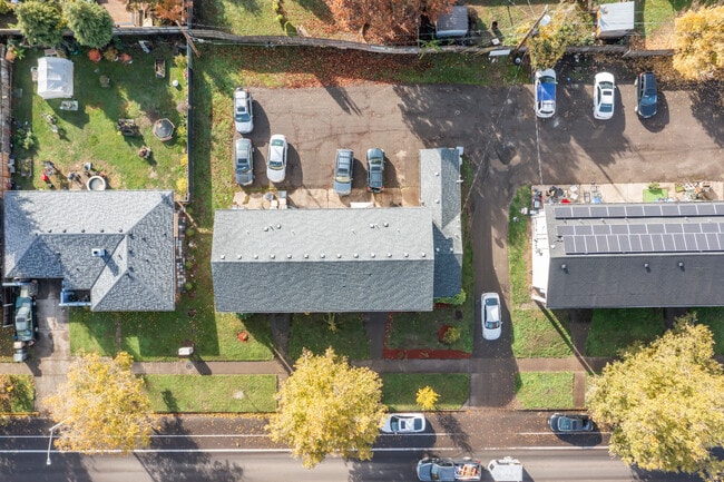
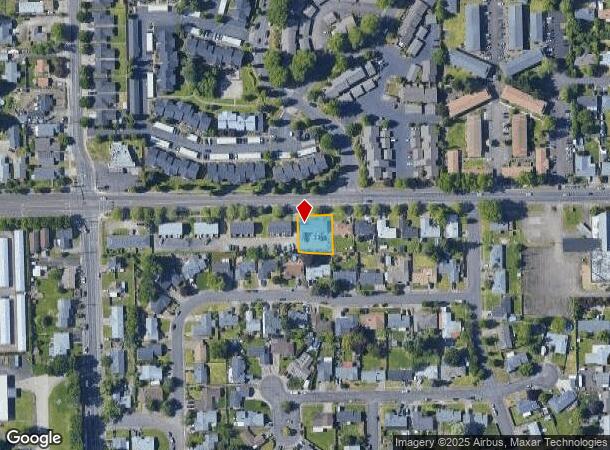
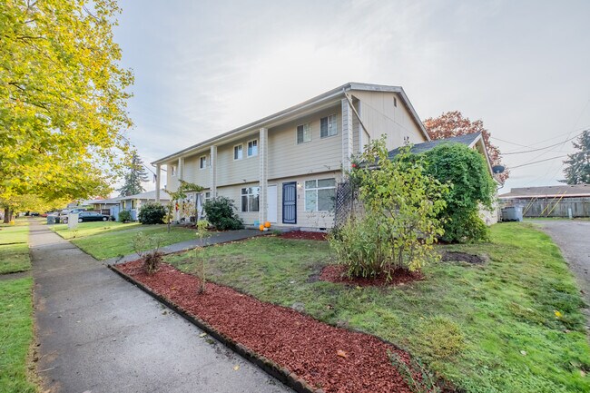
This Property Is For Sale
NEARBY LISTINGS FOR SALE OR LEASE
Property Detail
530 34Th Ave Se
Albany, OR
Taylor, J C, Addition
0126736
11S03W18DC
Quadruplex
Linn
X
Oregon
41043C0526G
1
2025
0.24 AC
2025
Linn County
020700
Portland
3,440 SF
DEMOGRAPHICS near 530 34Th Ave Se
1 Mile
3 Mile
5 Mile
2024 Total Population
11,141
46,134
62,598
2029 Population
11,263
46,899
63,659
Pop Growth 2024-2029
+ 1.10%
+ 1.66%
+ 1.69%
Average Age
38
40
41
2024 Total Households
4,349
18,395
24,472
HH Growth 2024-2029
+ 1.13%
+ 1.73%
+ 1.74%
Median Household Inc
$66,976
$67,719
$73,646
Avg Household Size
2.50
2.40
2.50
2024 Avg HH Vehicles
2.00
2.00
2.00
Median Home Value
$342,875
$368,863
$402,272
Median Year Built
1975
1977
1979
Nearby Places
- Restaurants
- Banks
- Shops
- Fitness
- Groceries
PUBLIC TRANSPORTATION
COMMUTER RAIL
Albany Amtrak Station (Amtrak Cascades - Amtrak, Coast Starlight - Amtrak)
DRIVE
WALK
Distance
Albany Amtrak Station (Amtrak Cascades - Amtrak, Coast Starlight - Amtrak)
4 min
2.5 mi
Freight Ports
Port of Portland
DRIVE
WALK
Distance
Port of Portland
94 min
74.1 mi
Nearby Properties
Address
Land Use
TOTAL SIZE
Lot Size
Zoning
Address
Land Use
TOTAL SIZE
Lot Size
Zoning
1.94 AC
Address
Land Use
TOTAL SIZE
Lot Size
Zoning
8,842 SF
73.88 AC
RS-6.5
Address
Land Use
TOTAL SIZE
Lot Size
Zoning
104.75 AC
LI
Address
Land Use
TOTAL SIZE
Lot Size
Zoning
34.91 AC
LI
Address
Land Use
TOTAL SIZE
Lot Size
Zoning
9.32 AC
LI
Address
Land Use
TOTAL SIZE
Lot Size
Zoning
41.22 AC
LI
Address
Land Use
TOTAL SIZE
Lot Size
Zoning
84,415 SF
70.68 AC
RS-6.5
Address
Land Use
TOTAL SIZE
Lot Size
Zoning
18.57 AC
RC
Address
Land Use
TOTAL SIZE
Lot Size
Zoning
33,540 SF
2.19 AC
ES
Address
Land Use
TOTAL SIZE
Lot Size
Zoning
23,340 SF
10.60 AC
CC
Address
Land Use
TOTAL SIZE
Lot Size
Zoning
28.17 AC
HI
Address
Land Use
TOTAL SIZE
Lot Size
Zoning
58,202 SF
5.14 AC
RM
Address
Land Use
TOTAL SIZE
Lot Size
Zoning
20.04 AC
LI
Address
Land Use
TOTAL SIZE
Lot Size
Zoning
3.75 AC
OP
Address
Land Use
TOTAL SIZE
Lot Size
Zoning
13.01 AC
RC
Address
Land Use
TOTAL SIZE
Lot Size
Zoning
67,716 SF
6.90 AC
LI
Address
Land Use
TOTAL SIZE
Lot Size
Zoning
43.06 AC
RS-6.5
Address
Land Use
TOTAL SIZE
Lot Size
Zoning
84,000 SF
8.99 AC
RC
Address
Land Use
TOTAL SIZE
Lot Size
Zoning
50,648 SF
8.35 AC
RS-6.5
Address
Land Use
TOTAL SIZE
Lot Size
Zoning
45,543 SF
24.28 AC
LI
Address
Land Use
TOTAL SIZE
Lot Size
Zoning
11.01 AC
CC
Address
Land Use
TOTAL SIZE
Lot Size
Zoning
666 SF
6.32 AC
RM
Address
Land Use
TOTAL SIZE
Lot Size
Zoning
11,296 SF
1.36 AC
HM
Address
Land Use
TOTAL SIZE
Lot Size
Zoning
3,591 SF
2.15 AC
RM
Address
Land Use
TOTAL SIZE
Lot Size
Zoning
151,290 SF
5.45 AC
RM
Address
Land Use
TOTAL SIZE
Lot Size
Zoning
19,950 SF
11.11 AC
RC
Address
Land Use
TOTAL SIZE
Lot Size
Zoning
5.27 AC
MUC
Address
Land Use
TOTAL SIZE
Lot Size
Zoning
52,626 SF
5.40 AC
RS-6.5
Address
Land Use
TOTAL SIZE
Lot Size
Zoning
Address
Land Use
TOTAL SIZE
Lot Size
Zoning
1,795 SF
8.98 AC
RC
The World's #1 Commercial Real Estate Marketplace
Connect with us
© 2025 CoStar Group
The information above has been obtained from sources believed reliable. While we do not doubt its accuracy we have not verified it and make no guarantee, warranty or representation about it. It is your responsibility to independently confirm its accuracy and completeness. Any projections, opinions, assumptions, or estimates used are for example only and do not represent the current or future performance of the property. The value of this transaction to you depends on tax and other factors which should be evaluated by your tax, financial, and legal advisors. You and your advisors should conduct a careful, independent investigation of the property to determine to your satisfaction the suitability of the property for your needs.