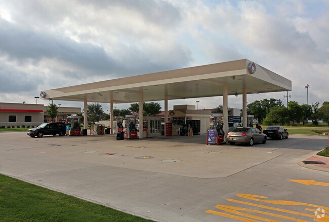
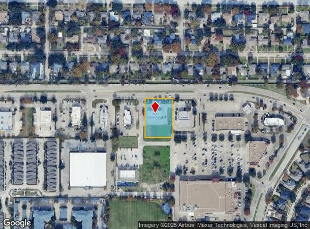
Property Record
530 Centennial Blvd, Richardson, TX 75081

NEARBY LISTINGS FOR SALE OR LEASE
Property Detail
530 Centennial Blvd
Dallas-Fort Worth-Arlington, TX
Buckingham Estates
420175000A16A0000
BUCKINGHAM ESTATES BLK A LT 16A ACS 1.0336 INT20080401301 DD12302008 CO-DC 0175000A01601 2CR0175000A
Servicestation
Dallas
X
Texas
48085C0505K
16a
2024
1.03 AC
2025
Garland
019039
Dallas/Ft Worth
198 SF
DEMOGRAPHICS near 530 Centennial Blvd
1 Mile
3 Mile
5 Mile
2024 Total Population
19,479
162,862
393,023
2029 Population
19,355
161,258
400,139
Pop Growth 2024-2029
(0.64%)
(0.98%)
+ 1.81%
Average Age
39
36
37
2024 Total Households
7,565
62,143
155,820
HH Growth 2024-2029
(0.89%)
(1.16%)
+ 2.33%
Median Household Inc
$78,536
$54,950
$64,482
Avg Household Size
2.50
2.50
2.40
2024 Avg HH Vehicles
2.00
2.00
2.00
Median Home Value
$321,881
$281,049
$336,500
Median Year Built
1984
1977
1979
Nearby Places
Map Layers
Map Styles
 Street
 Aerial
- Restaurants
- Banks
- Shops
- Fitness
- Groceries
PUBLIC TRANSPORTATION
AIRPORT
Dallas Love Field
DRIVE
WALK
Distance
Dallas Love Field
24 min
15.5 mi
Dallas-Fort Worth International
DRIVE
WALK
Distance
Dallas-Fort Worth International
32 min
24.4 mi
Nearby Properties
Address
Land Use
TOTAL SIZE
Lot Size
Zoning
Address
Land Use
TOTAL SIZE
Lot Size
Zoning
7,706,477 SF
245.55 AC
Z116
Address
Land Use
TOTAL SIZE
Lot Size
Zoning
1,252,860 SF
57.08 AC
Z239
Address
Land Use
TOTAL SIZE
Lot Size
Zoning
641,243 SF
20.67 AC
Z109
Address
Land Use
TOTAL SIZE
Lot Size
Zoning
706,061 SF
36.76 AC
Z109
Address
Land Use
TOTAL SIZE
Lot Size
Zoning
428,956 SF
18.76 AC
Z291
Address
Land Use
TOTAL SIZE
Lot Size
Zoning
249,692 SF
244.62 AC
Z239
Address
Land Use
TOTAL SIZE
Lot Size
Zoning
402,815 SF
5.64 AC
Z236
Address
Land Use
TOTAL SIZE
Lot Size
Zoning
537,928 SF
11.13 AC
Z109
Address
Land Use
TOTAL SIZE
Lot Size
Zoning
426,467 SF
24.12 AC
Z142
Address
Land Use
TOTAL SIZE
Lot Size
Zoning
1,464,834 SF
18.37 AC
Z109
Address
Land Use
TOTAL SIZE
Lot Size
Zoning
316,085 SF
13.73 AC
Z107
Address
Land Use
TOTAL SIZE
Lot Size
Zoning
347,933 SF
12.61 AC
Z164
Address
Land Use
TOTAL SIZE
Lot Size
Zoning
1,099,201 SF
107.82 AC
Z116
Address
Land Use
TOTAL SIZE
Lot Size
Zoning
470,129 SF
4.43 AC
Z112
Address
Land Use
TOTAL SIZE
Lot Size
Zoning
201,226 SF
14.55 AC
Z143
Address
Land Use
TOTAL SIZE
Lot Size
Zoning
310,119 SF
9.65 AC
Z150
Address
Land Use
TOTAL SIZE
Lot Size
Zoning
187.94 AC
Z31
Address
Land Use
TOTAL SIZE
Lot Size
Zoning
291,579 SF
13.79 AC
Z151
Address
Land Use
TOTAL SIZE
Lot Size
Zoning
572,364 SF
8.41 AC
Z112
Address
Land Use
TOTAL SIZE
Lot Size
Zoning
699,105 SF
5.12 AC
Z137
Address
Land Use
TOTAL SIZE
Lot Size
Zoning
334,910 SF
14.26 AC
Z151
Address
Land Use
TOTAL SIZE
Lot Size
Zoning
431,982 SF
19.32 AC
Z164
Address
Land Use
TOTAL SIZE
Lot Size
Zoning
277,296 SF
13.54 AC
Z207
Address
Land Use
TOTAL SIZE
Lot Size
Zoning
292,347 SF
3.82 AC
Z236
Address
Land Use
TOTAL SIZE
Lot Size
Zoning
211,913 SF
6.76 AC
Z151
Address
Land Use
TOTAL SIZE
Lot Size
Zoning
275,557 SF
13.64 AC
Z291
Address
Land Use
TOTAL SIZE
Lot Size
Zoning
347,718 SF
18.61 AC
Z163
Address
Land Use
TOTAL SIZE
Lot Size
Zoning
211,006 SF
11.25 AC
Z09
Address
Land Use
TOTAL SIZE
Lot Size
Zoning
356,941 SF
7.47 AC
Z236
Address
Land Use
TOTAL SIZE
Lot Size
Zoning
227,584 SF
12.03 AC
Z165
The World's #1 Commercial Real Estate Marketplace
Connect with us
© 2025 CoStar Group
The information above has been obtained from sources believed reliable. While we do not doubt its accuracy we have not verified it and make no guarantee, warranty or representation about it. It is your responsibility to independently confirm its accuracy and completeness. Any projections, opinions, assumptions, or estimates used are for example only and do not represent the current or future performance of the property. The value of this transaction to you depends on tax and other factors which should be evaluated by your tax, financial, and legal advisors. You and your advisors should conduct a careful, independent investigation of the property to determine to your satisfaction the suitability of the property for your needs.