Property Record
530 J F Smith Ave, Slidell, LA 70460
NEARBY LISTINGS FOR SALE OR LEASE
Property Detail
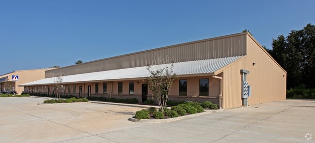
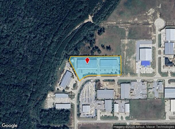
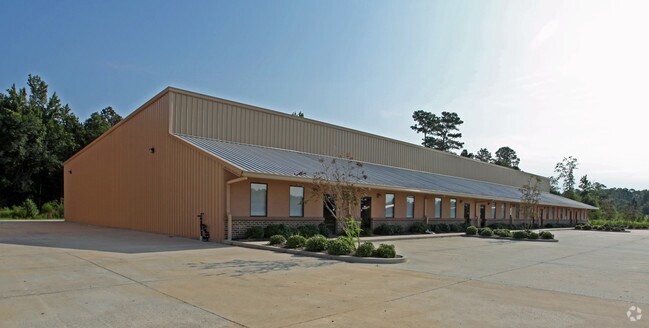
530 J F Smith Ave
New Orleans-Metairie, LA
Johnny Smith Memorial Bus Park
112886
LOT 8 JOHNNY F SMITH MEMORIAL BUSINESS PARK CONT 3.018 ACS INST NO 1264380 INST NO 1306017 INST NO 1559888
Commercialnec
St Tammany
ARE
Louisiana
2025
8
2024
3.02 AC
040713
Slidell
42,995 SF
New Orleans/Metairie/Kenner
DEMOGRAPHICS near 530 J F Smith Ave
1 Mile
3 Mile
5 Mile
2024 Total Population
3,040
35,218
81,694
2029 Population
3,296
37,877
87,882
Pop Growth 2024-2029
+ 8.42%
+ 7.55%
+ 7.57%
Average Age
37
40
40
2024 Total Households
1,149
13,335
31,094
HH Growth 2024-2029
+ 8.44%
+ 7.52%
+ 7.61%
Median Household Inc
$39,720
$58,141
$58,632
Avg Household Size
2.60
2.60
2.60
2024 Avg HH Vehicles
2.00
2.00
2.00
Median Home Value
$120,492
$176,530
$184,879
Median Year Built
1992
1983
1987
Nearby Places
Map Layers
Map Styles
 Street
 Aerial
- Restaurants
- Banks
- Shops
- Fitness
- Groceries
PUBLIC TRANSPORTATION
COMMUTER RAIL
Slidell Amtrak Station (Crescent - Amtrak)
DRIVE
WALK
Distance
Slidell Amtrak Station (Crescent - Amtrak)
8 min
3.5 mi
Freight Ports
Port of New Orleans
DRIVE
WALK
Distance
Port of New Orleans
55 min
39.7 mi
Nearby Properties
Address
Land Use
TOTAL SIZE
Lot Size
Zoning
Address
Land Use
TOTAL SIZE
Lot Size
Zoning
858,000 SF
59.39 AC
Address
Land Use
TOTAL SIZE
Lot Size
Zoning
660,450 SF
68.42 AC
Address
Land Use
TOTAL SIZE
Lot Size
Zoning
120,000 SF
6.75 AC
Address
Land Use
TOTAL SIZE
Lot Size
Zoning
104,000 SF
2.89 AC
Address
Land Use
TOTAL SIZE
Lot Size
Zoning
205,496 SF
27.47 AC
Address
Land Use
TOTAL SIZE
Lot Size
Zoning
192,685 SF
Address
Land Use
TOTAL SIZE
Lot Size
Zoning
157,561 SF
10.06 AC
Address
Land Use
TOTAL SIZE
Lot Size
Zoning
137,402 SF
76.02 AC
Address
Land Use
TOTAL SIZE
Lot Size
Zoning
127,681 SF
3 AC
Address
Land Use
TOTAL SIZE
Lot Size
Zoning
63,135 SF
12.49 AC
Address
Land Use
TOTAL SIZE
Lot Size
Zoning
105,633 SF
11 AC
Address
Land Use
TOTAL SIZE
Lot Size
Zoning
104,821 SF
10.09 AC
Address
Land Use
TOTAL SIZE
Lot Size
Zoning
105,300 SF
8.75 AC
Address
Land Use
TOTAL SIZE
Lot Size
Zoning
144,674 SF
13.10 AC
Address
Land Use
TOTAL SIZE
Lot Size
Zoning
142,482 SF
1.23 AC
Address
Land Use
TOTAL SIZE
Lot Size
Zoning
84,000 SF
10.84 AC
Address
Land Use
TOTAL SIZE
Lot Size
Zoning
87,153 SF
4.38 AC
Address
Land Use
TOTAL SIZE
Lot Size
Zoning
184,551 SF
20 AC
Address
Land Use
TOTAL SIZE
Lot Size
Zoning
91,149 SF
4.26 AC
Address
Land Use
TOTAL SIZE
Lot Size
Zoning
115,666 SF
9.14 AC
Address
Land Use
TOTAL SIZE
Lot Size
Zoning
104,702 SF
11.69 AC
Address
Land Use
TOTAL SIZE
Lot Size
Zoning
114,806 SF
10.22 AC
Address
Land Use
TOTAL SIZE
Lot Size
Zoning
66,634 SF
14 AC
Address
Land Use
TOTAL SIZE
Lot Size
Zoning
42,995 SF
5.20 AC
Address
Land Use
TOTAL SIZE
Lot Size
Zoning
1,378 SF
1.19 AC
Address
Land Use
TOTAL SIZE
Lot Size
Zoning
65,449 SF
6.89 AC
Address
Land Use
TOTAL SIZE
Lot Size
Zoning
2,233 SF
1.69 AC
Address
Land Use
TOTAL SIZE
Lot Size
Zoning
51,784 SF
9.68 AC
Address
Land Use
TOTAL SIZE
Lot Size
Zoning
66,251 SF
6.40 AC
Address
Land Use
TOTAL SIZE
Lot Size
Zoning
50,616 SF
37.20 AC
The World's #1 Commercial Real Estate Marketplace
Connect with us
© 2026 CoStar Group
The information above has been obtained from sources believed reliable. While we do not doubt its accuracy we have not verified it and make no guarantee, warranty or representation about it. It is your responsibility to independently confirm its accuracy and completeness. Any projections, opinions, assumptions, or estimates used are for example only and do not represent the current or future performance of the property. The value of this transaction to you depends on tax and other factors which should be evaluated by your tax, financial, and legal advisors. You and your advisors should conduct a careful, independent investigation of the property to determine to your satisfaction the suitability of the property for your needs.