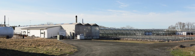
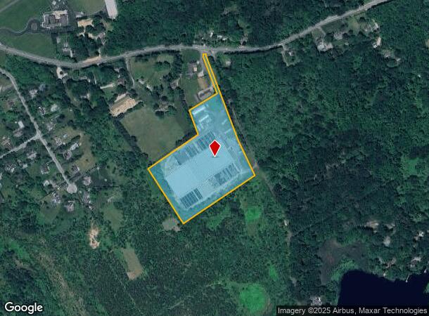
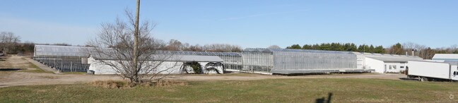
Property Record
530 Kirkup Ln, Mattituck, NY 11952
NEARBY LISTINGS FOR SALE OR LEASE
Property Detail
530 Kirkup Ln
Nassau County-Suffolk County, NY
BOOK 12516 PAGE 665 BILL 015459
1000-121-00-03-00-007-004
Suffolk
Farms
New York
X
7
36103C0477H
11.31 AC
2024
Eastern Suffolk
2024
Long Island (New York)
170004
DEMOGRAPHICS near 530 Kirkup Ln
1 Mile
3 Mile
5 Mile
2024 Total Population
642
7,966
13,667
2029 Population
655
7,999
13,603
Pop Growth 2024-2029
+ 2.02%
+ 0.41%
(0.47%)
Average Age
46
46
46
2024 Total Households
252
3,171
5,369
HH Growth 2024-2029
+ 1.59%
+ 0.13%
(0.80%)
Median Household Inc
$104,762
$101,740
$106,147
Avg Household Size
2.50
2.40
2.50
2024 Avg HH Vehicles
2.00
2.00
2.00
Median Home Value
$758,875
$726,002
$732,554
Median Year Built
1975
1976
1976
Nearby Places
- Restaurants
- Banks
- Shops
- Fitness
- Groceries
PUBLIC TRANSPORTATION
COMMUTER RAIL
Mattituck Station (Greenport Branch - Long Island Rail Road)
DRIVE
WALK
Distance
Mattituck Station (Greenport Branch - Long Island Rail Road)
4 min
1.7 mi
Riverhead Station (Greenport Branch - Long Island Rail Road)
DRIVE
WALK
Distance
Riverhead Station (Greenport Branch - Long Island Rail Road)
16 min
8.6 mi
AIRPORT
Long Island MacArthur
DRIVE
WALK
Distance
Long Island MacArthur
59 min
36.4 mi
Nearby Properties
Address
Land Use
TOTAL SIZE
Lot Size
Zoning
Address
Land Use
TOTAL SIZE
Lot Size
Zoning
214.30 AC
10
Address
Land Use
TOTAL SIZE
Lot Size
Zoning
30.40 AC
R-80
Address
Land Use
TOTAL SIZE
Lot Size
Zoning
1,688 SF
34.47 AC
09
Address
Land Use
TOTAL SIZE
Lot Size
Zoning
5.01 AC
10
Address
Land Use
TOTAL SIZE
Lot Size
Zoning
5,338 SF
159.30 AC
4
Address
Land Use
TOTAL SIZE
Lot Size
Zoning
11.39 AC
10
Address
Land Use
TOTAL SIZE
Lot Size
Zoning
1,980 SF
63.11 AC
09
Address
Land Use
TOTAL SIZE
Lot Size
Zoning
13,943 SF
4.40 AC
04
Address
Land Use
TOTAL SIZE
Lot Size
Zoning
2,928 SF
85.90 AC
04
Address
Land Use
TOTAL SIZE
Lot Size
Zoning
2,588 SF
107.80 AC
03
Address
Land Use
TOTAL SIZE
Lot Size
Zoning
8,891 SF
2.91 AC
4
Address
Land Use
TOTAL SIZE
Lot Size
Zoning
392 SF
52.39 AC
09
Address
Land Use
TOTAL SIZE
Lot Size
Zoning
2,392 SF
26.20 AC
09
Address
Land Use
TOTAL SIZE
Lot Size
Zoning
2,832 SF
9.23 AC
04
Address
Land Use
TOTAL SIZE
Lot Size
Zoning
4,288 SF
33.20 AC
04
Address
Land Use
TOTAL SIZE
Lot Size
Zoning
9,230 SF
19.70 AC
04
Address
Land Use
TOTAL SIZE
Lot Size
Zoning
7,013 SF
2.34 AC
04
Address
Land Use
TOTAL SIZE
Lot Size
Zoning
133.10 AC
04
Address
Land Use
TOTAL SIZE
Lot Size
Zoning
3,945 SF
6.27 AC
APZ
Address
Land Use
TOTAL SIZE
Lot Size
Zoning
392 SF
19.31 AC
09
Address
Land Use
TOTAL SIZE
Lot Size
Zoning
2,526 SF
41 AC
04
Address
Land Use
TOTAL SIZE
Lot Size
Zoning
145.30 AC
04
Address
Land Use
TOTAL SIZE
Lot Size
Zoning
2,112 SF
23.30 AC
09
Address
Land Use
TOTAL SIZE
Lot Size
Zoning
0.79 AC
VILLA
Address
Land Use
TOTAL SIZE
Lot Size
Zoning
3,570 SF
1.10 AC
HC
Address
Land Use
TOTAL SIZE
Lot Size
Zoning
8.75 AC
B
Address
Land Use
TOTAL SIZE
Lot Size
Zoning
2,012 SF
4.12 AC
04
Address
Land Use
TOTAL SIZE
Lot Size
Zoning
5,483 SF
18.43 AC
04
Address
Land Use
TOTAL SIZE
Lot Size
Zoning
2,317 SF
0.71 AC
04
Address
Land Use
TOTAL SIZE
Lot Size
Zoning
82.20 AC
04
The World's #1 Commercial Real Estate Marketplace
Connect with us
© 2025 CoStar Group
The information above has been obtained from sources believed reliable. While we do not doubt its accuracy we have not verified it and make no guarantee, warranty or representation about it. It is your responsibility to independently confirm its accuracy and completeness. Any projections, opinions, assumptions, or estimates used are for example only and do not represent the current or future performance of the property. The value of this transaction to you depends on tax and other factors which should be evaluated by your tax, financial, and legal advisors. You and your advisors should conduct a careful, independent investigation of the property to determine to your satisfaction the suitability of the property for your needs.