Property Record
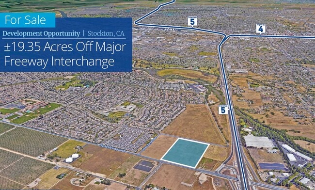
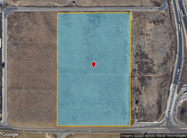
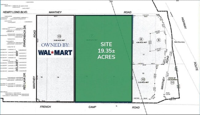
530 W Manthey Rd, Stockton, CA 95206
This Property Is For Sale
NEARBY LISTINGS FOR SALE OR LEASE
Property Detail
530 W Manthey Rd
Stockton-Lodi, CA
Ray
168-190-07
REDRAWN OCT-10-2000 FROM ORIGINAL APN 193-030-05
Commercialacreage
San Joaquin
X
California
06077C0470F
12,13
2025
19.35 AC
2025
Stockton
002503
Stockton/Modesto
DEMOGRAPHICS near 530 W Manthey Rd
1 Mile
3 Mile
5 Mile
2024 Total Population
8,870
66,949
144,359
2029 Population
9,333
70,515
152,009
Pop Growth 2024-2029
+ 5.22%
+ 5.33%
+ 5.30%
Average Age
35
35
35
2024 Total Households
2,079
16,604
40,126
HH Growth 2024-2029
+ 5.48%
+ 5.45%
+ 5.52%
Median Household Inc
$93,948
$68,519
$55,623
Avg Household Size
3.90
3.70
3.30
2024 Avg HH Vehicles
2.00
2.00
2.00
Median Home Value
$377,200
$350,846
$341,904
Median Year Built
1999
1992
1973
Nearby Places
Map Layers
Map Styles
 Street
 Aerial
- Restaurants
- Banks
- Shops
- Fitness
- Groceries
PUBLIC TRANSPORTATION
COMMUTER RAIL
Stockton (San Joaquins - Amtrak)
DRIVE
WALK
Distance
Stockton (San Joaquins - Amtrak)
7 min
4.6 mi
Stockton (ACE Train - Altamont Commuter Express (ACE), Altamont Corridor Express - Altamont Commuter Express (ACE))
DRIVE
WALK
Distance
Stockton (ACE Train - Altamont Commuter Express (ACE), Altamont Corridor Express - Altamont Commuter Express (ACE))
9 min
5.7 mi
AIRPORT
Stockton Metro
DRIVE
WALK
Distance
Stockton Metro
6 min
3.0 mi
Freight Ports
Port of Stockton
DRIVE
WALK
Distance
Port of Stockton
10 min
6.5 mi
Nearby Properties
Address
Land Use
TOTAL SIZE
Lot Size
Zoning
Address
Land Use
TOTAL SIZE
Lot Size
Zoning
240,210 SF
66.15 AC
Address
Land Use
TOTAL SIZE
Lot Size
Zoning
615,440 SF
76.23 AC
IG
Address
Land Use
TOTAL SIZE
Lot Size
Zoning
39.06 AC
Address
Land Use
TOTAL SIZE
Lot Size
Zoning
656,200 SF
24.07 AC
IG
Address
Land Use
TOTAL SIZE
Lot Size
Zoning
824,735 SF
52.87 AC
Address
Land Use
TOTAL SIZE
Lot Size
Zoning
326,934 SF
56.52 AC
IG
Address
Land Use
TOTAL SIZE
Lot Size
Zoning
545,832 SF
29.07 AC
Address
Land Use
TOTAL SIZE
Lot Size
Zoning
574,560 SF
32.34 AC
Address
Land Use
TOTAL SIZE
Lot Size
Zoning
419,608 SF
23.01 AC
IG
Address
Land Use
TOTAL SIZE
Lot Size
Zoning
511,718 SF
21.18 AC
Address
Land Use
TOTAL SIZE
Lot Size
Zoning
508,800 SF
24 AC
Address
Land Use
TOTAL SIZE
Lot Size
Zoning
434,900 SF
17.05 AC
Address
Land Use
TOTAL SIZE
Lot Size
Zoning
512,000 SF
20.16 AC
Address
Land Use
TOTAL SIZE
Lot Size
Zoning
521,500 SF
12.06 AC
Address
Land Use
TOTAL SIZE
Lot Size
Zoning
513,778 SF
11.88 AC
Address
Land Use
TOTAL SIZE
Lot Size
Zoning
69,954 SF
24.92 AC
Address
Land Use
TOTAL SIZE
Lot Size
Zoning
586,610 SF
27.36 AC
Address
Land Use
TOTAL SIZE
Lot Size
Zoning
522,400 SF
23.72 AC
Address
Land Use
TOTAL SIZE
Lot Size
Zoning
328,500 SF
12.27 AC
Address
Land Use
TOTAL SIZE
Lot Size
Zoning
452,000 SF
20.42 AC
Address
Land Use
TOTAL SIZE
Lot Size
Zoning
42,267 SF
10.53 AC
Address
Land Use
TOTAL SIZE
Lot Size
Zoning
443,640 SF
24.30 AC
Address
Land Use
TOTAL SIZE
Lot Size
Zoning
178,761 SF
11.43 AC
Address
Land Use
TOTAL SIZE
Lot Size
Zoning
164,000 SF
7.62 AC
Address
Land Use
TOTAL SIZE
Lot Size
Zoning
1,568 SF
129.97 AC
IG
Address
Land Use
TOTAL SIZE
Lot Size
Zoning
223,470 SF
21.05 AC
Address
Land Use
TOTAL SIZE
Lot Size
Zoning
295,680 SF
37.65 AC
Address
Land Use
TOTAL SIZE
Lot Size
Zoning
500,000 SF
28.38 AC
The World's #1 Commercial Real Estate Marketplace
Connect with us
© 2025 CoStar Group
The information above has been obtained from sources believed reliable. While we do not doubt its accuracy we have not verified it and make no guarantee, warranty or representation about it. It is your responsibility to independently confirm its accuracy and completeness. Any projections, opinions, assumptions, or estimates used are for example only and do not represent the current or future performance of the property. The value of this transaction to you depends on tax and other factors which should be evaluated by your tax, financial, and legal advisors. You and your advisors should conduct a careful, independent investigation of the property to determine to your satisfaction the suitability of the property for your needs.