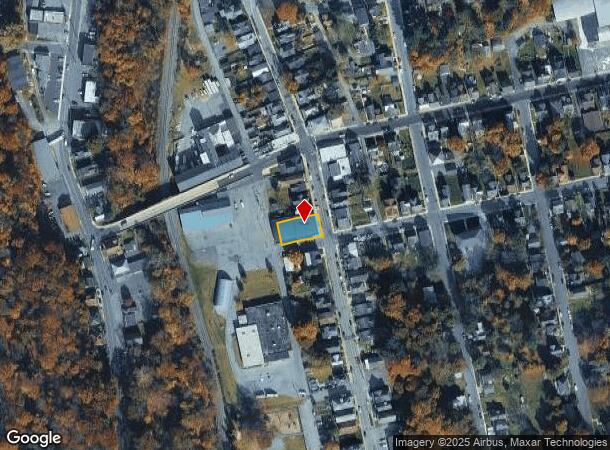
Property Record
530 S Main St, Bangor, PA 18013
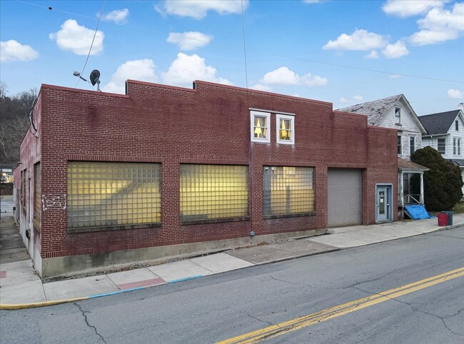

This Property Is For Sale
NEARBY LISTINGS FOR SALE OR LEASE
Property Detail
530 S Main St
Manufacturinglight
Northampton
AE
Pennsylvania
42095C0152E
0.19 AC
2025
Lehigh Valley
2025
Philadelphia
015203
Allentown-Bethlehem-Easton, PA-NJ
8,652 SF
E9NE3D-1-2-0102
DEMOGRAPHICS near 530 S Main St
1 Mile
3 Mile
5 Mile
2024 Total Population
5,944
18,072
26,457
2029 Population
6,007
18,227
26,561
Pop Growth 2024-2029
+ 1.06%
+ 0.86%
+ 0.39%
Average Age
40
42
43
2024 Total Households
2,413
7,143
10,645
HH Growth 2024-2029
+ 1.45%
+ 1.15%
+ 0.57%
Median Household Inc
$59,744
$72,133
$70,220
Avg Household Size
2.40
2.50
2.40
2024 Avg HH Vehicles
2.00
2.00
2.00
Median Home Value
$183,264
$222,804
$239,857
Median Year Built
1948
1951
1956
Nearby Places
- Restaurants
- Banks
- Shops
- Fitness
- Groceries
PUBLIC TRANSPORTATION
AIRPORT
Lehigh Valley International
DRIVE
WALK
Distance
Lehigh Valley International
39 min
23.8 mi
Nearby Properties
Address
Land Use
TOTAL SIZE
Lot Size
Zoning
Address
Land Use
TOTAL SIZE
Lot Size
Zoning
104,971 SF
20.30 AC
A
Address
Land Use
TOTAL SIZE
Lot Size
Zoning
87,926 SF
20.76 AC
R2
Address
Land Use
TOTAL SIZE
Lot Size
Zoning
63,477 SF
16.68 AC
C
Address
Land Use
TOTAL SIZE
Lot Size
Zoning
73,531 SF
1.44 AC
GB
Address
Land Use
TOTAL SIZE
Lot Size
Zoning
7,704 SF
1.78 AC
R78
Address
Land Use
TOTAL SIZE
Lot Size
Zoning
3,440 SF
6.73 AC
IE
Address
Land Use
TOTAL SIZE
Lot Size
Zoning
43,744 SF
10.12 AC
C
Address
Land Use
TOTAL SIZE
Lot Size
Zoning
20,608 SF
4.77 AC
R10
Address
Land Use
TOTAL SIZE
Lot Size
Zoning
22,430 SF
35 AC
R2
Address
Land Use
TOTAL SIZE
Lot Size
Zoning
72,160 SF
12 AC
R2
Address
Land Use
TOTAL SIZE
Lot Size
Zoning
72,160 SF
12 AC
R2
Address
Land Use
TOTAL SIZE
Lot Size
Zoning
20,339 SF
2.46 AC
R10
Address
Land Use
TOTAL SIZE
Lot Size
Zoning
9,000 SF
11.75 AC
IE
Address
Land Use
TOTAL SIZE
Lot Size
Zoning
280.40 AC
W
Address
Land Use
TOTAL SIZE
Lot Size
Zoning
15,777 SF
15.57 AC
IE
Address
Land Use
TOTAL SIZE
Lot Size
Zoning
118,318 SF
1.58 AC
IL
Address
Land Use
TOTAL SIZE
Lot Size
Zoning
33,444 SF
6.98 AC
I1
Address
Land Use
TOTAL SIZE
Lot Size
Zoning
24,000 SF
4.25 AC
C
Address
Land Use
TOTAL SIZE
Lot Size
Zoning
15,400 SF
5 AC
I
Address
Land Use
TOTAL SIZE
Lot Size
Zoning
18,892 SF
3.23 AC
R1
Address
Land Use
TOTAL SIZE
Lot Size
Zoning
4,700 SF
8.36 AC
IL
Address
Land Use
TOTAL SIZE
Lot Size
Zoning
33,841 SF
1.24 AC
R1
Address
Land Use
TOTAL SIZE
Lot Size
Zoning
9,900 SF
36.77 AC
R2
Address
Land Use
TOTAL SIZE
Lot Size
Zoning
30,302 SF
3.03 AC
R1
Address
Land Use
TOTAL SIZE
Lot Size
Zoning
24,803 SF
0.23 AC
R78
Address
Land Use
TOTAL SIZE
Lot Size
Zoning
19,993 SF
0.72 AC
R78
Address
Land Use
TOTAL SIZE
Lot Size
Zoning
6,600 SF
11.60 AC
R10
Address
Land Use
TOTAL SIZE
Lot Size
Zoning
15,066 SF
0.54 AC
R78
Address
Land Use
TOTAL SIZE
Lot Size
Zoning
44,200 SF
4.55 AC
I1
Address
Land Use
TOTAL SIZE
Lot Size
Zoning
7,794 SF
0.59 AC
IL
The World's #1 Commercial Real Estate Marketplace
Connect with us
© 2025 CoStar Group
The information above has been obtained from sources believed reliable. While we do not doubt its accuracy we have not verified it and make no guarantee, warranty or representation about it. It is your responsibility to independently confirm its accuracy and completeness. Any projections, opinions, assumptions, or estimates used are for example only and do not represent the current or future performance of the property. The value of this transaction to you depends on tax and other factors which should be evaluated by your tax, financial, and legal advisors. You and your advisors should conduct a careful, independent investigation of the property to determine to your satisfaction the suitability of the property for your needs.