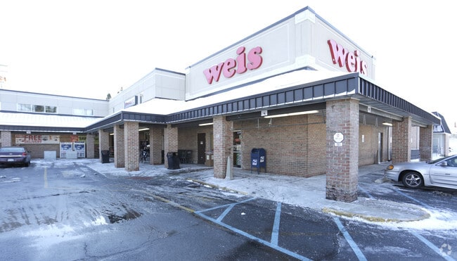
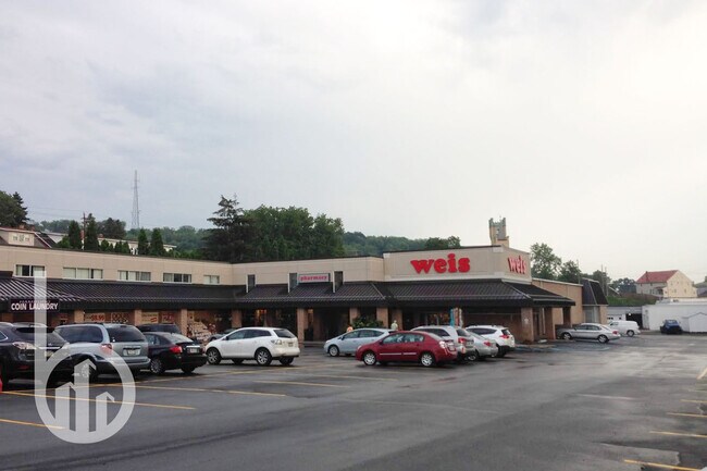
Property Record
530 State St, Mertztown, PA 19539


NEARBY LISTINGS FOR SALE OR LEASE
-
-
View all Mertztown listings for sale on LoopNet.com
Property Detail
530 State St
Regionalshoppingcenterormallwithanchorstore
Berks
AE
Pennsylvania
42011C0161G
2.60 AC
2025
Berks County
2025
Philadelphia
014201
Reading, PA
37,840 SF
46-4495-17-10-6171
DEMOGRAPHICS near 530 State St
1 Mile
3 Mile
5 Mile
2024 Total Population
4,891
9,324
15,281
2029 Population
4,949
9,431
15,427
Pop Growth 2024-2029
+ 1.19%
+ 1.15%
+ 0.96%
Average Age
43
43
44
2024 Total Households
2,178
3,897
6,303
HH Growth 2024-2029
+ 1.19%
+ 1.15%
+ 0.98%
Median Household Inc
$59,331
$63,966
$66,525
Avg Household Size
2.20
2.30
2.40
2024 Avg HH Vehicles
2.00
2.00
2.00
Median Home Value
$170,984
$204,187
$213,840
Median Year Built
1954
1971
1971
Nearby Places
Map Layers
Map Styles
 Street
 Aerial
- Restaurants
- Banks
- Shops
- Fitness
- Groceries
PUBLIC TRANSPORTATION
AIRPORT
Lehigh Valley International
DRIVE
WALK
Distance
Lehigh Valley International
47 min
32.3 mi
Freight Ports
Port of Philadelphia
DRIVE
WALK
Distance
Port of Philadelphia
105 min
80.6 mi
SALE & LEASE HISTORY
LISTING DATE
SALE/LEASE

Sep 24, 2020
For Sale
Jan 10, 2020
For Sale
Feb 01, 2023
For Sale
Nearby Properties
Address
Land Use
TOTAL SIZE
Lot Size
Zoning
Address
Land Use
TOTAL SIZE
Lot Size
Zoning
1,240,000 SF
91.95 AC
Address
Land Use
TOTAL SIZE
Lot Size
Zoning
1,240,000 SF
66.73 AC
Address
Land Use
TOTAL SIZE
Lot Size
Zoning
600,000 SF
38.59 AC
Address
Land Use
TOTAL SIZE
Lot Size
Zoning
197,512 SF
40.46 AC
Address
Land Use
TOTAL SIZE
Lot Size
Zoning
504,364 SF
63.90 AC
Address
Land Use
TOTAL SIZE
Lot Size
Zoning
296,000 SF
28.83 AC
Address
Land Use
TOTAL SIZE
Lot Size
Zoning
336,000 SF
34.01 AC
Address
Land Use
TOTAL SIZE
Lot Size
Zoning
324,000 SF
28.13 AC
Address
Land Use
TOTAL SIZE
Lot Size
Zoning
149,600 SF
13.95 AC
Address
Land Use
TOTAL SIZE
Lot Size
Zoning
252,448 SF
24.30 AC
Address
Land Use
TOTAL SIZE
Lot Size
Zoning
91,520 SF
8.17 AC
Address
Land Use
TOTAL SIZE
Lot Size
Zoning
85,370 SF
22.78 AC
Address
Land Use
TOTAL SIZE
Lot Size
Zoning
151,987 SF
20.60 AC
Address
Land Use
TOTAL SIZE
Lot Size
Zoning
76,242 SF
13.29 AC
Address
Land Use
TOTAL SIZE
Lot Size
Zoning
58,642 SF
10.11 AC
Address
Land Use
TOTAL SIZE
Lot Size
Zoning
53,915 SF
7.75 AC
Address
Land Use
TOTAL SIZE
Lot Size
Zoning
119,589 SF
11.86 AC
Address
Land Use
TOTAL SIZE
Lot Size
Zoning
81,020 SF
10.69 AC
Address
Land Use
TOTAL SIZE
Lot Size
Zoning
83,968 SF
6.38 AC
Address
Land Use
TOTAL SIZE
Lot Size
Zoning
57,578 SF
5.16 AC
Address
Land Use
TOTAL SIZE
Lot Size
Zoning
35,976 SF
5 AC
Address
Land Use
TOTAL SIZE
Lot Size
Zoning
45,334 SF
6.46 AC
Address
Land Use
TOTAL SIZE
Lot Size
Zoning
49,915 SF
400.06 AC
Address
Land Use
TOTAL SIZE
Lot Size
Zoning
11,850 SF
12.91 AC
Address
Land Use
TOTAL SIZE
Lot Size
Zoning
3,337 SF
912.69 AC
Address
Land Use
TOTAL SIZE
Lot Size
Zoning
22,759 SF
4.35 AC
Address
Land Use
TOTAL SIZE
Lot Size
Zoning
9,576 SF
5.08 AC
Address
Land Use
TOTAL SIZE
Lot Size
Zoning
15,103 SF
3 AC
Address
Land Use
TOTAL SIZE
Lot Size
Zoning
55,960 SF
13.53 AC
Address
Land Use
TOTAL SIZE
Lot Size
Zoning
10,119 SF
3.01 AC
The World's #1 Commercial Real Estate Marketplace
Connect with us
© 2026 CoStar Group
The information above has been obtained from sources believed reliable. While we do not doubt its accuracy we have not verified it and make no guarantee, warranty or representation about it. It is your responsibility to independently confirm its accuracy and completeness. Any projections, opinions, assumptions, or estimates used are for example only and do not represent the current or future performance of the property. The value of this transaction to you depends on tax and other factors which should be evaluated by your tax, financial, and legal advisors. You and your advisors should conduct a careful, independent investigation of the property to determine to your satisfaction the suitability of the property for your needs.