Property Record
530 W Little York Rd, Houston, TX 77091

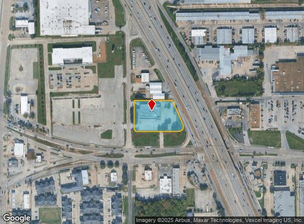
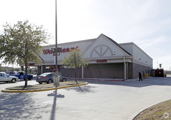
This Property Is For Sale
Current Lease Availabilities
NEARBY LISTINGS FOR SALE OR LEASE
Property Detail
530 W Little York Rd
1180900010001
Little York
Storebuilding
RES A BLK 1 WALGREENS-W LITTLE YORK & I-45
X
Harris
48201C0660M
Texas
2024
1.55 AC
2025
Near Northwest Oaks
533301
Houston
13,281 SF
Houston-The Woodlands-Sugar Land, TX
DEMOGRAPHICS near 530 W Little York Rd
1 Mile
3 Mile
5 Mile
2024 Total Population
13,230
117,490
340,176
2029 Population
13,440
120,023
347,663
Pop Growth 2024-2029
+ 1.59%
+ 2.16%
+ 2.20%
Average Age
35
36
36
2024 Total Households
4,364
37,558
115,232
HH Growth 2024-2029
+ 1.51%
+ 2.26%
+ 2.38%
Median Household Inc
$31,332
$38,873
$45,484
Avg Household Size
2.90
3.00
2.90
2024 Avg HH Vehicles
2.00
2.00
2.00
Median Home Value
$158,597
$166,466
$200,105
Median Year Built
1979
1970
1974
Nearby Places
- Restaurants
- Banks
- Shops
- Fitness
- Groceries
PUBLIC TRANSPORTATION
COMMUTER RAIL
Houston (Sunset Limited - Amtrak)
DRIVE
WALK
Distance
Houston (Sunset Limited - Amtrak)
13 min
8.1 mi
AIRPORT
George Bush Intcntl/Houston
DRIVE
WALK
Distance
George Bush Intcntl/Houston
18 min
12.9 mi
William P Hobby
DRIVE
WALK
Distance
William P Hobby
33 min
20.9 mi
Freight Ports
Port of Houston
DRIVE
WALK
Distance
Port of Houston
25 min
16.4 mi
Nearby Properties
Address
Land Use
TOTAL SIZE
Lot Size
Zoning
Address
Land Use
TOTAL SIZE
Lot Size
Zoning
594,105 SF
43.68 AC
Address
Land Use
TOTAL SIZE
Lot Size
Zoning
279,452 SF
5.69 AC
Address
Land Use
TOTAL SIZE
Lot Size
Zoning
531,786 SF
17.60 AC
Address
Land Use
TOTAL SIZE
Lot Size
Zoning
194,990 SF
16.36 AC
Address
Land Use
TOTAL SIZE
Lot Size
Zoning
361,869 SF
39.62 AC
Address
Land Use
TOTAL SIZE
Lot Size
Zoning
200,511 SF
9.48 AC
Address
Land Use
TOTAL SIZE
Lot Size
Zoning
139,886 SF
10.02 AC
Address
Land Use
TOTAL SIZE
Lot Size
Zoning
178,824 SF
5.85 AC
Address
Land Use
TOTAL SIZE
Lot Size
Zoning
43.68 AC
Address
Land Use
TOTAL SIZE
Lot Size
Zoning
179,804 SF
11.24 AC
Address
Land Use
TOTAL SIZE
Lot Size
Zoning
49,933 SF
8.35 AC
Address
Land Use
TOTAL SIZE
Lot Size
Zoning
85,376 SF
4.35 AC
Address
Land Use
TOTAL SIZE
Lot Size
Zoning
66,588 SF
3.95 AC
Address
Land Use
TOTAL SIZE
Lot Size
Zoning
220,976 SF
12.06 AC
Address
Land Use
TOTAL SIZE
Lot Size
Zoning
29,029 SF
17.85 AC
Address
Land Use
TOTAL SIZE
Lot Size
Zoning
271,832 SF
14.93 AC
Address
Land Use
TOTAL SIZE
Lot Size
Zoning
69,257 SF
20.32 AC
Address
Land Use
TOTAL SIZE
Lot Size
Zoning
184,536 SF
10 AC
Address
Land Use
TOTAL SIZE
Lot Size
Zoning
108,155 SF
14.64 AC
Address
Land Use
TOTAL SIZE
Lot Size
Zoning
126,662 SF
4.77 AC
Address
Land Use
TOTAL SIZE
Lot Size
Zoning
112,212 SF
10.51 AC
Address
Land Use
TOTAL SIZE
Lot Size
Zoning
84,582 SF
4.86 AC
Address
Land Use
TOTAL SIZE
Lot Size
Zoning
131,494 SF
Address
Land Use
TOTAL SIZE
Lot Size
Zoning
69,777 SF
2.36 AC
Address
Land Use
TOTAL SIZE
Lot Size
Zoning
190,634 SF
8.75 AC
Address
Land Use
TOTAL SIZE
Lot Size
Zoning
48,420 SF
22.93 AC
Address
Land Use
TOTAL SIZE
Lot Size
Zoning
91,726 SF
6.23 AC
Address
Land Use
TOTAL SIZE
Lot Size
Zoning
139,709 SF
4.76 AC
Address
Land Use
TOTAL SIZE
Lot Size
Zoning
86,400 SF
3.51 AC
Address
Land Use
TOTAL SIZE
Lot Size
Zoning
242,147 SF
12.51 AC
The World's #1 Commercial Real Estate Marketplace
Connect with us
© 2025 CoStar Group
The information above has been obtained from sources believed reliable. While we do not doubt its accuracy we have not verified it and make no guarantee, warranty or representation about it. It is your responsibility to independently confirm its accuracy and completeness. Any projections, opinions, assumptions, or estimates used are for example only and do not represent the current or future performance of the property. The value of this transaction to you depends on tax and other factors which should be evaluated by your tax, financial, and legal advisors. You and your advisors should conduct a careful, independent investigation of the property to determine to your satisfaction the suitability of the property for your needs.