Property Record
Atlantic Ave, Hamilton, NJ 08330
This Property Is For Sale
NEARBY LISTINGS FOR SALE OR LEASE
Property Detail
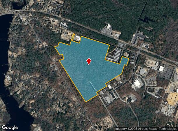
Atlantic Ave
Atlantic City-Hammonton, NJ
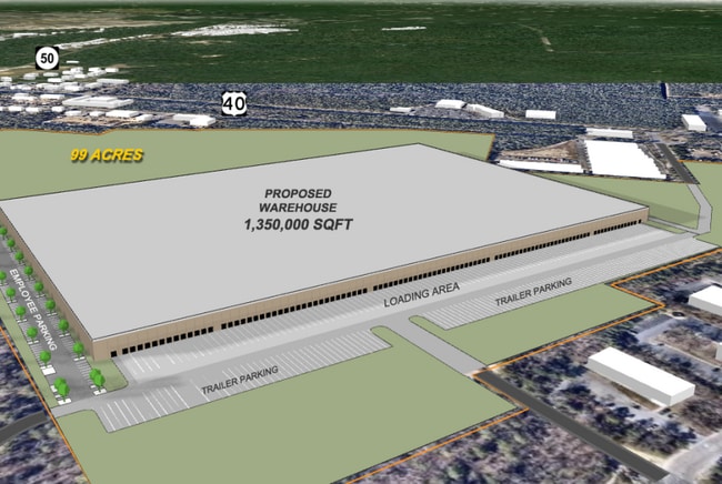
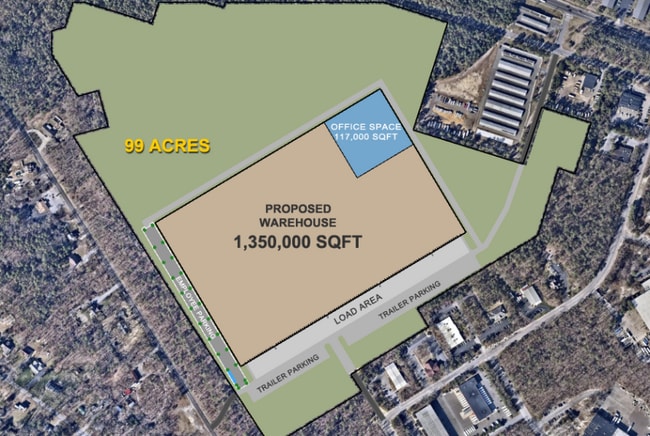
ADDITIONAL LOTS: IBPZA/FACILITY NAME: VACANT LAND
12-00991-0000-00003
Atlantic
Governmentalpublicusegeneral
New Jersey
X
3
34001C0279F
98.86 AC
0
Atlantic City/Hammonton
2025
Philadelphia
011401
DEMOGRAPHICS near Atlantic Ave
1 Mile
3 Mile
5 Mile
2024 Total Population
1,494
12,791
30,056
2029 Population
1,461
12,517
29,422
Pop Growth 2024-2029
(2.21%)
(2.14%)
(2.11%)
Average Age
43
42
41
2024 Total Households
538
4,768
11,012
HH Growth 2024-2029
(3.35%)
(2.87%)
(2.73%)
Median Household Inc
$78,090
$72,725
$77,437
Avg Household Size
2.40
2.50
2.60
2024 Avg HH Vehicles
2.00
2.00
2.00
Median Home Value
$273,129
$220,949
$230,314
Median Year Built
1988
1983
1989
Nearby Places
- Restaurants
- Banks
- Shops
- Fitness
- Groceries
PUBLIC TRANSPORTATION
COMMUTER RAIL
Egg Harbor City (Atlantic City Line - NJ Transit Commuter Rail (NJ Transit))
DRIVE
WALK
Distance
Egg Harbor City (Atlantic City Line - NJ Transit Commuter Rail (NJ Transit))
14 min
8.3 mi
AIRPORT
Atlantic City International
DRIVE
WALK
Distance
Atlantic City International
35 min
11.1 mi
Freight Ports
Broadway Terminal - Pier 5
DRIVE
WALK
Distance
Broadway Terminal - Pier 5
60 min
45.1 mi
Nearby Properties
Address
Land Use
TOTAL SIZE
Lot Size
Zoning
Address
Land Use
TOTAL SIZE
Lot Size
Zoning
48.59 AC
IBP
Address
Land Use
TOTAL SIZE
Lot Size
Zoning
78.84 AC
GA-M
Address
Land Use
TOTAL SIZE
Lot Size
Zoning
19.70 AC
IBP
Address
Land Use
TOTAL SIZE
Lot Size
Zoning
53.17 AC
IBP
Address
Land Use
TOTAL SIZE
Lot Size
Zoning
312.70 AC
GA-M
Address
Land Use
TOTAL SIZE
Lot Size
Zoning
31.17 AC
GA-M
Address
Land Use
TOTAL SIZE
Lot Size
Zoning
28.50 AC
IBP
Address
Land Use
TOTAL SIZE
Lot Size
Zoning
622 SF
142.51 AC
PFMH
Address
Land Use
TOTAL SIZE
Lot Size
Zoning
75,248 SF
20.85 AC
IBP
Address
Land Use
TOTAL SIZE
Lot Size
Zoning
11,572 SF
19.68 AC
DC
Address
Land Use
TOTAL SIZE
Lot Size
Zoning
45.45 AC
IBP
Address
Land Use
TOTAL SIZE
Lot Size
Zoning
71,556 SF
7.13 AC
R-9
Address
Land Use
TOTAL SIZE
Lot Size
Zoning
13,845 SF
18.28 AC
PVD
Address
Land Use
TOTAL SIZE
Lot Size
Zoning
22,723 SF
16.53 AC
IBP
Address
Land Use
TOTAL SIZE
Lot Size
Zoning
3,138 SF
12.26 AC
RD-5
Address
Land Use
TOTAL SIZE
Lot Size
Zoning
59,354 SF
5.29 AC
IBP
Address
Land Use
TOTAL SIZE
Lot Size
Zoning
90,000 SF
5.64 AC
IBP
Address
Land Use
TOTAL SIZE
Lot Size
Zoning
19,543 SF
115.47 AC
GA-I
Address
Land Use
TOTAL SIZE
Lot Size
Zoning
59,362 SF
3.47 AC
R-9
Address
Land Use
TOTAL SIZE
Lot Size
Zoning
10,204 SF
4.82 AC
GA-L
Address
Land Use
TOTAL SIZE
Lot Size
Zoning
115.56 AC
RA
Address
Land Use
TOTAL SIZE
Lot Size
Zoning
5.36 AC
IBP
Address
Land Use
TOTAL SIZE
Lot Size
Zoning
1.14 AC
GC
Address
Land Use
TOTAL SIZE
Lot Size
Zoning
10.41 AC
DC
Address
Land Use
TOTAL SIZE
Lot Size
Zoning
24,925 SF
8.89 AC
IBP
Address
Land Use
TOTAL SIZE
Lot Size
Zoning
28.60 AC
IBP
Address
Land Use
TOTAL SIZE
Lot Size
Zoning
11.08 AC
IBP
Address
Land Use
TOTAL SIZE
Lot Size
Zoning
2,944 SF
29.83 AC
GA-L
Address
Land Use
TOTAL SIZE
Lot Size
Zoning
728 SF
14.84 AC
R-22
The World's #1 Commercial Real Estate Marketplace
Connect with us
© 2025 CoStar Group
The information above has been obtained from sources believed reliable. While we do not doubt its accuracy we have not verified it and make no guarantee, warranty or representation about it. It is your responsibility to independently confirm its accuracy and completeness. Any projections, opinions, assumptions, or estimates used are for example only and do not represent the current or future performance of the property. The value of this transaction to you depends on tax and other factors which should be evaluated by your tax, financial, and legal advisors. You and your advisors should conduct a careful, independent investigation of the property to determine to your satisfaction the suitability of the property for your needs.