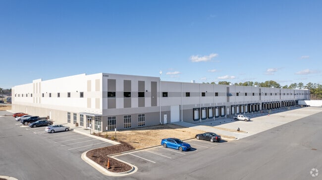
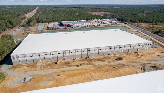
Property Record
5300 Corporation Dr, Hope Mills, NC 28348

NEARBY LISTINGS FOR SALE OR LEASE
Property Detail
5300 Corporation Dr
Fayetteville, NC
E. West Mountain/301 South
0423-74-2100
WILLIAMS LIBERTY POINT LLC LO:2 PL:00145-0019
Warehouse
Cumberland
X
North Carolina
3720042300J
2
2025
13.78 AC
2025
East Fayetteville
003003
Fayetteville
DEMOGRAPHICS near 5300 Corporation Dr
1 Mile
3 Mile
5 Mile
2024 Total Population
809
20,944
54,551
2029 Population
802
20,846
54,300
Pop Growth 2024-2029
(0.87%)
(0.47%)
(0.46%)
Average Age
35
35
36
2024 Total Households
272
7,419
19,922
HH Growth 2024-2029
(0.74%)
(0.47%)
(0.46%)
Median Household Inc
$78,205
$69,737
$60,612
Avg Household Size
3.00
2.80
2.70
2024 Avg HH Vehicles
2.00
2.00
2.00
Median Home Value
$223,182
$188,976
$168,527
Median Year Built
2001
1998
1995
Nearby Places
Map Layers
Map Styles
 Street
 Aerial
- Restaurants
- Banks
- Shops
- Fitness
- Groceries
PUBLIC TRANSPORTATION
AIRPORT
Fayetteville Regional/Grannis Field
DRIVE
WALK
Distance
Fayetteville Regional/Grannis Field
12 min
5.4 mi
SALE & LEASE HISTORY
LISTING DATE
SALE/LEASE

Aug 28, 2019
For Lease
Nearby Properties
Address
Land Use
TOTAL SIZE
Lot Size
Zoning
Address
Land Use
TOTAL SIZE
Lot Size
Zoning
1,117,824 SF
227 AC
MP
Address
Land Use
TOTAL SIZE
Lot Size
Zoning
56,622 SF
104.70 AC
R10
Address
Land Use
TOTAL SIZE
Lot Size
Zoning
123,423 SF
70.84 AC
A1
Address
Land Use
TOTAL SIZE
Lot Size
Zoning
66,637 SF
48.75 AC
A1
Address
Land Use
TOTAL SIZE
Lot Size
Zoning
14,000 SF
97.50 AC
MP
Address
Land Use
TOTAL SIZE
Lot Size
Zoning
500,548 SF
45.12 AC
MP
Address
Land Use
TOTAL SIZE
Lot Size
Zoning
531.87 AC
A1
Address
Land Use
TOTAL SIZE
Lot Size
Zoning
104,048 SF
25 AC
A1
Address
Land Use
TOTAL SIZE
Lot Size
Zoning
259,960 SF
31 AC
MP
Address
Land Use
TOTAL SIZE
Lot Size
Zoning
182,589 SF
39.04 AC
MP
Address
Land Use
TOTAL SIZE
Lot Size
Zoning
21.10 AC
MP
Address
Land Use
TOTAL SIZE
Lot Size
Zoning
16.41 AC
MP
Address
Land Use
TOTAL SIZE
Lot Size
Zoning
9,404 SF
62.05 AC
RR
Address
Land Use
TOTAL SIZE
Lot Size
Zoning
51,180 SF
26 AC
R6
Address
Land Use
TOTAL SIZE
Lot Size
Zoning
2,347 SF
7.22 AC
R5A
Address
Land Use
TOTAL SIZE
Lot Size
Zoning
1,970 SF
5.04 AC
R5A
Address
Land Use
TOTAL SIZE
Lot Size
Zoning
58,915 SF
18.75 AC
MP
Address
Land Use
TOTAL SIZE
Lot Size
Zoning
64,445 SF
37.03 AC
MP
Address
Land Use
TOTAL SIZE
Lot Size
Zoning
5,666 SF
5.09 AC
R6
Address
Land Use
TOTAL SIZE
Lot Size
Zoning
115,200 SF
33.80 AC
MP
Address
Land Use
TOTAL SIZE
Lot Size
Zoning
377 SF
6.51 AC
R5
Address
Land Use
TOTAL SIZE
Lot Size
Zoning
144,000 SF
21.30 AC
MP
Address
Land Use
TOTAL SIZE
Lot Size
Zoning
10.59 AC
CP-PLANNED
Address
Land Use
TOTAL SIZE
Lot Size
Zoning
10,200 SF
14.37 AC
C3
Address
Land Use
TOTAL SIZE
Lot Size
Zoning
18,684 SF
18.71 AC
R15
Address
Land Use
TOTAL SIZE
Lot Size
Zoning
2,400 SF
6.74 AC
R5A
Address
Land Use
TOTAL SIZE
Lot Size
Zoning
14,100 SF
9.05 AC
CP
Address
Land Use
TOTAL SIZE
Lot Size
Zoning
15,288 SF
1.88 AC
O&I
Address
Land Use
TOTAL SIZE
Lot Size
Zoning
29,240 SF
5.33 AC
MP
The World's #1 Commercial Real Estate Marketplace
Connect with us
© 2026 CoStar Group
The information above has been obtained from sources believed reliable. While we do not doubt its accuracy we have not verified it and make no guarantee, warranty or representation about it. It is your responsibility to independently confirm its accuracy and completeness. Any projections, opinions, assumptions, or estimates used are for example only and do not represent the current or future performance of the property. The value of this transaction to you depends on tax and other factors which should be evaluated by your tax, financial, and legal advisors. You and your advisors should conduct a careful, independent investigation of the property to determine to your satisfaction the suitability of the property for your needs.