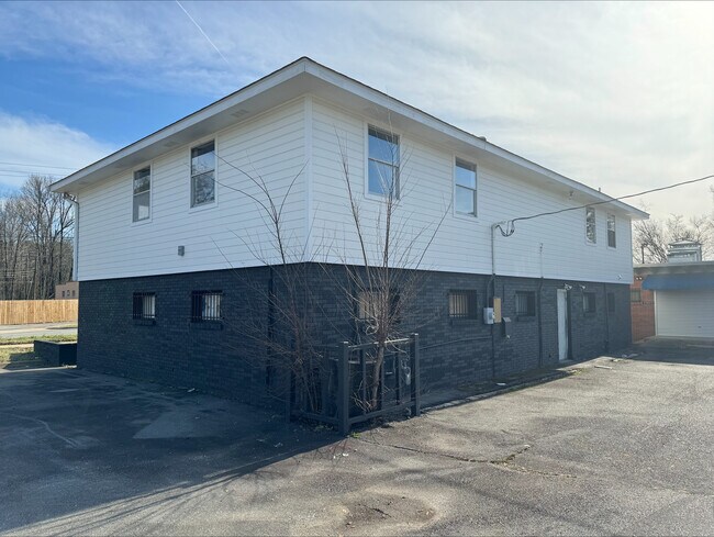
Property Record
5300 Mabelvale Pike, Little Rock, AR 72209


NEARBY LISTINGS FOR SALE OR LEASE
Property Detail
5300 Mabelvale Pike
34L-313-00-077-00
Holland Heights #6
Officebuilding
PT SW SW BEG 198 E & 29.56 S32*16E OF NW COR SW SW TH S32*16 E 120 TO N R/W MABEL RD N 47*31 E 150 19 FT W 174 95 TO BEG 19 1N 12W LESS & EXCEPT 1194.27 SQFT FOR R/W PER DEED 05-061107
X
Pulaski
05119C0454J
Arkansas
2025
0.24 AC
2025
Southwest
002001
Little Rock/N Little Rock
1,792 SF
Little Rock-North Little Rock-Conway, AR
DEMOGRAPHICS near 5300 Mabelvale Pike
1 Mile
3 Mile
5 Mile
2024 Total Population
6,009
56,849
127,752
2029 Population
6,023
57,431
128,670
Pop Growth 2024-2029
+ 0.23%
+ 1.02%
+ 0.72%
Average Age
35
36
38
2024 Total Households
2,264
21,980
54,448
HH Growth 2024-2029
+ 0.18%
+ 1.23%
+ 0.75%
Median Household Inc
$39,963
$37,507
$45,246
Avg Household Size
2.50
2.40
2.20
2024 Avg HH Vehicles
2.00
2.00
2.00
Median Home Value
$62,966
$89,564
$147,062
Median Year Built
1968
1972
1970
Nearby Places
Map Layers
Map Styles
 Street
 Aerial
- Restaurants
- Banks
- Shops
- Fitness
- Groceries
PUBLIC TRANSPORTATION
COMMUTER RAIL
DRIVE
WALK
Distance
13 min
6.8 mi
AIRPORT
Bill and Hillary Clinton Ntl/Adams Field
DRIVE
WALK
Distance
Bill and Hillary Clinton Ntl/Adams Field
15 min
9.5 mi
SALE & LEASE HISTORY
LISTING DATE
SALE/LEASE

Feb 23, 2024
For Sale
Nearby Properties
Address
Land Use
TOTAL SIZE
Lot Size
Zoning
Address
Land Use
TOTAL SIZE
Lot Size
Zoning
10 SF
29.02 AC
Address
Land Use
TOTAL SIZE
Lot Size
Zoning
168,041 SF
29.22 AC
Address
Land Use
TOTAL SIZE
Lot Size
Zoning
19,142 SF
5.54 AC
Address
Land Use
TOTAL SIZE
Lot Size
Zoning
63,244 SF
14.21 AC
Address
Land Use
TOTAL SIZE
Lot Size
Zoning
78,004 SF
4.44 AC
Address
Land Use
TOTAL SIZE
Lot Size
Zoning
88,687 SF
1.67 AC
Address
Land Use
TOTAL SIZE
Lot Size
Zoning
52,577 SF
Address
Land Use
TOTAL SIZE
Lot Size
Zoning
52,220 SF
Address
Land Use
TOTAL SIZE
Lot Size
Zoning
55,121 SF
13.76 AC
Address
Land Use
TOTAL SIZE
Lot Size
Zoning
79,751 SF
28.57 AC
Address
Land Use
TOTAL SIZE
Lot Size
Zoning
239,345 SF
19.70 AC
Address
Land Use
TOTAL SIZE
Lot Size
Zoning
16,707 SF
13.93 AC
Address
Land Use
TOTAL SIZE
Lot Size
Zoning
34,925 SF
12.59 AC
Address
Land Use
TOTAL SIZE
Lot Size
Zoning
83,466 SF
5.46 AC
Address
Land Use
TOTAL SIZE
Lot Size
Zoning
41,652 SF
10.86 AC
Address
Land Use
TOTAL SIZE
Lot Size
Zoning
50,433 SF
22.23 AC
Address
Land Use
TOTAL SIZE
Lot Size
Zoning
24,492 SF
8.92 AC
Address
Land Use
TOTAL SIZE
Lot Size
Zoning
4,260 SF
3.80 AC
Address
Land Use
TOTAL SIZE
Lot Size
Zoning
131,278 SF
6.37 AC
Address
Land Use
TOTAL SIZE
Lot Size
Zoning
139,410 SF
8.35 AC
Address
Land Use
TOTAL SIZE
Lot Size
Zoning
95,788 SF
2.55 AC
Address
Land Use
TOTAL SIZE
Lot Size
Zoning
171,509 SF
4.86 AC
Address
Land Use
TOTAL SIZE
Lot Size
Zoning
24,520 SF
10.92 AC
Address
Land Use
TOTAL SIZE
Lot Size
Zoning
51,990 SF
8 AC
Address
Land Use
TOTAL SIZE
Lot Size
Zoning
6,161 SF
40.08 AC
Address
Land Use
TOTAL SIZE
Lot Size
Zoning
182,636 SF
16.86 AC
Address
Land Use
TOTAL SIZE
Lot Size
Zoning
152,350 SF
13.57 AC
Address
Land Use
TOTAL SIZE
Lot Size
Zoning
75,900 SF
20.18 AC
Address
Land Use
TOTAL SIZE
Lot Size
Zoning
35,069 SF
43.11 AC
Address
Land Use
TOTAL SIZE
Lot Size
Zoning
59,076 SF
22.27 AC
The World's #1 Commercial Real Estate Marketplace
Connect with us
© 2026 CoStar Group
The information above has been obtained from sources believed reliable. While we do not doubt its accuracy we have not verified it and make no guarantee, warranty or representation about it. It is your responsibility to independently confirm its accuracy and completeness. Any projections, opinions, assumptions, or estimates used are for example only and do not represent the current or future performance of the property. The value of this transaction to you depends on tax and other factors which should be evaluated by your tax, financial, and legal advisors. You and your advisors should conduct a careful, independent investigation of the property to determine to your satisfaction the suitability of the property for your needs.