Property Record
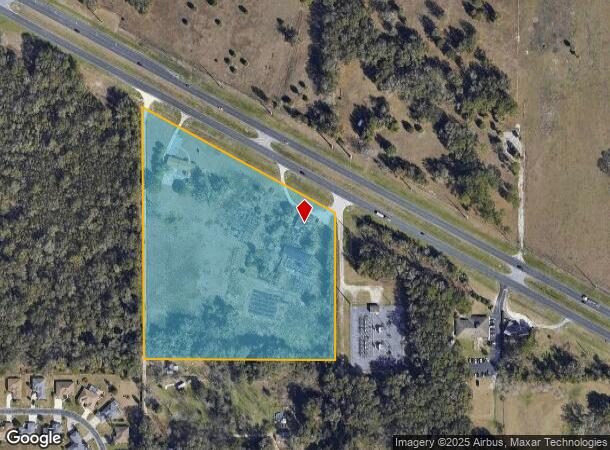
5300 N Us Highway 27, Ocala, FL 34482
NEARBY LISTINGS FOR SALE OR LEASE
Property Detail
5300 N Us Highway 27
21582-000-00
SEC 04 TWP 15 RGE 21 THAT PT OF NW 1/4 OF NE 1/4 & W 1/2 OF THE SW 1/4 OF NE 1/4 S OF SR 500 EXC S 55 FT TOGETHER WITH A PERPETUAL RIGHT OF WAY EASEMENT OVER THE W 20 FT OF THE FOLLOWING DESC LAND: THAT PART OF NW 1/4 OF NE 1/4 AND THE W 1/2 OF SW 1/
Financialbuilding
Marion
X
Florida
12083C0504E
10.17 AC
2025
Outlying Marion County
2025
Ocala
002504
Ocala, FL
4,748 SF
DEMOGRAPHICS near 5300 N Us Highway 27
1 Mile
3 Mile
5 Mile
2024 Total Population
3,794
15,081
47,825
2029 Population
4,278
17,111
54,165
Pop Growth 2024-2029
+ 12.76%
+ 13.46%
+ 13.26%
Average Age
64
47
42
2024 Total Households
2,161
6,485
19,190
HH Growth 2024-2029
+ 12.73%
+ 13.40%
+ 13.31%
Median Household Inc
$72,415
$56,911
$48,025
Avg Household Size
1.80
2.20
2.30
2024 Avg HH Vehicles
2.00
2.00
2.00
Median Home Value
$235,691
$202,957
$195,738
Median Year Built
2000
1996
1990
Nearby Places
Map Layers
Map Styles
 Street
 Aerial
- Restaurants
- Banks
- Shops
- Fitness
- Groceries
Nearby Properties
Address
Land Use
TOTAL SIZE
Lot Size
Zoning
Address
Land Use
TOTAL SIZE
Lot Size
Zoning
2,015,469 SF
169.30 AC
M1
Address
Land Use
TOTAL SIZE
Lot Size
Zoning
704,765 SF
71.04 AC
GU
Address
Land Use
TOTAL SIZE
Lot Size
Zoning
85,986 SF
15.68 AC
PUD
Address
Land Use
TOTAL SIZE
Lot Size
Zoning
1,085,670 SF
87.92 AC
M1
Address
Land Use
TOTAL SIZE
Lot Size
Zoning
612,196 SF
50.06 AC
M1
Address
Land Use
TOTAL SIZE
Lot Size
Zoning
617,520 SF
46.08 AC
M2
Address
Land Use
TOTAL SIZE
Lot Size
Zoning
441,040 SF
150.01 AC
M1
Address
Land Use
TOTAL SIZE
Lot Size
Zoning
458,983 SF
35.14 AC
M1
Address
Land Use
TOTAL SIZE
Lot Size
Zoning
135,945 SF
22.30 AC
PD
Address
Land Use
TOTAL SIZE
Lot Size
Zoning
444,381 SF
60 AC
M1
Address
Land Use
TOTAL SIZE
Lot Size
Zoning
152,355 SF
973.50 AC
GU
Address
Land Use
TOTAL SIZE
Lot Size
Zoning
403,023 SF
47.47 AC
M1
Address
Land Use
TOTAL SIZE
Lot Size
Zoning
62,164 SF
27.64 AC
PD
Address
Land Use
TOTAL SIZE
Lot Size
Zoning
350,895 SF
27.85 AC
M1
Address
Land Use
TOTAL SIZE
Lot Size
Zoning
422,369 SF
51.11 AC
M2
Address
Land Use
TOTAL SIZE
Lot Size
Zoning
482,618 SF
34.54 AC
M2
Address
Land Use
TOTAL SIZE
Lot Size
Zoning
92,095 SF
216.43 AC
M1
Address
Land Use
TOTAL SIZE
Lot Size
Zoning
360,450 SF
20 AC
M1
Address
Land Use
TOTAL SIZE
Lot Size
Zoning
140,920 SF
28.09 AC
M2
Address
Land Use
TOTAL SIZE
Lot Size
Zoning
146,091 SF
43.91 AC
M1
Address
Land Use
TOTAL SIZE
Lot Size
Zoning
124,812 SF
27.07 AC
PUD
Address
Land Use
TOTAL SIZE
Lot Size
Zoning
79,199 SF
13.54 AC
B2
Address
Land Use
TOTAL SIZE
Lot Size
Zoning
160,796 SF
25.59 AC
M2
Address
Land Use
TOTAL SIZE
Lot Size
Zoning
384,930 SF
17.76 AC
M1
Address
Land Use
TOTAL SIZE
Lot Size
Zoning
153,456 SF
16.98 AC
M2
Address
Land Use
TOTAL SIZE
Lot Size
Zoning
94,360 SF
17.51 AC
B5
Address
Land Use
TOTAL SIZE
Lot Size
Zoning
101,760 SF
9.88 AC
M1
Address
Land Use
TOTAL SIZE
Lot Size
Zoning
11,351 SF
3.51 AC
B2
Address
Land Use
TOTAL SIZE
Lot Size
Zoning
120,571 SF
10.34 AC
M1
Address
Land Use
TOTAL SIZE
Lot Size
Zoning
28,325 SF
226.67 AC
PUD
The World's #1 Commercial Real Estate Marketplace
Connect with us
© 2026 CoStar Group
The information above has been obtained from sources believed reliable. While we do not doubt its accuracy we have not verified it and make no guarantee, warranty or representation about it. It is your responsibility to independently confirm its accuracy and completeness. Any projections, opinions, assumptions, or estimates used are for example only and do not represent the current or future performance of the property. The value of this transaction to you depends on tax and other factors which should be evaluated by your tax, financial, and legal advisors. You and your advisors should conduct a careful, independent investigation of the property to determine to your satisfaction the suitability of the property for your needs.