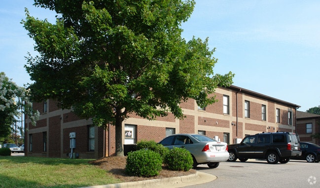
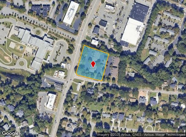
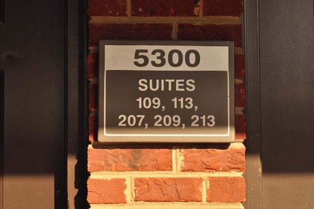
Property Record
5300 Six Forks Rd, Raleigh, NC 27609

Current Lease Availabilities
NEARBY LISTINGS FOR SALE OR LEASE
Property Detail
5300 Six Forks Rd
Raleigh, NC
Master Card Ph1 Windel Commons Condo
1706.11-65-1849-000
Wake
Condominium
North Carolina
X
1.79 AC
3720170600K
Six Forks/Falls of Neuse
1,200 SF
Raleigh/Durham
DEMOGRAPHICS near 5300 Six Forks Rd
1 Mile
3 Mile
5 Mile
2024 Total Population
10,924
93,134
244,525
2029 Population
11,930
101,172
265,618
Pop Growth 2024-2029
+ 9.21%
+ 8.63%
+ 8.63%
Average Age
42
41
40
2024 Total Households
5,149
43,621
110,755
HH Growth 2024-2029
+ 9.21%
+ 8.75%
+ 8.79%
Median Household Inc
$86,851
$83,151
$81,150
Avg Household Size
2.10
2.10
2.10
2024 Avg HH Vehicles
2.00
2.00
2.00
Median Home Value
$381,192
$415,772
$411,424
Median Year Built
1976
1985
1988
Nearby Places
- Restaurants
- Banks
- Shops
- Fitness
- Groceries
PUBLIC TRANSPORTATION
COMMUTER RAIL
Raleigh Union Station (Piedmont - North Carolina by Train (NC Train))
DRIVE
WALK
Distance
Raleigh Union Station (Piedmont - North Carolina by Train (NC Train))
13 min
5.7 mi
AIRPORT
Raleigh-Durham International
DRIVE
WALK
Distance
Raleigh-Durham International
21 min
11.2 mi
Nearby Properties
Address
Land Use
TOTAL SIZE
Lot Size
Zoning
Address
Land Use
TOTAL SIZE
Lot Size
Zoning
2,804,942 SF
57.23 AC
CX-12
Address
Land Use
TOTAL SIZE
Lot Size
Zoning
1,085,654 SF
16.87 AC
OX-5
Address
Land Use
TOTAL SIZE
Lot Size
Zoning
658,580 SF
3.30 AC
PD
Address
Land Use
TOTAL SIZE
Lot Size
Zoning
747,658 SF
11.12 AC
CX-12
Address
Land Use
TOTAL SIZE
Lot Size
Zoning
465,052 SF
2.65 AC
PD
Address
Land Use
TOTAL SIZE
Lot Size
Zoning
364,025 SF
2.19 AC
PD
Address
Land Use
TOTAL SIZE
Lot Size
Zoning
539,902 SF
1.28 AC
O&I-1
Address
Land Use
TOTAL SIZE
Lot Size
Zoning
482,597 SF
36.39 AC
RX-4
Address
Land Use
TOTAL SIZE
Lot Size
Zoning
303,238 SF
12.41 AC
PD
Address
Land Use
TOTAL SIZE
Lot Size
Zoning
495,697 SF
9.11 AC
OX-5
Address
Land Use
TOTAL SIZE
Lot Size
Zoning
544,122 SF
1.49 AC
PD
Address
Land Use
TOTAL SIZE
Lot Size
Zoning
355,931 SF
2.60 AC
PD
Address
Land Use
TOTAL SIZE
Lot Size
Zoning
284,958 SF
3.01 AC
PD
Address
Land Use
TOTAL SIZE
Lot Size
Zoning
390,365 SF
3.70 AC
OX-5
Address
Land Use
TOTAL SIZE
Lot Size
Zoning
366,905 SF
11.24 AC
OX-5
Address
Land Use
TOTAL SIZE
Lot Size
Zoning
282,285 SF
5.29 AC
PD
Address
Land Use
TOTAL SIZE
Lot Size
Zoning
349,485 SF
4.61 AC
OX-7
Address
Land Use
TOTAL SIZE
Lot Size
Zoning
525,558 SF
7.11 AC
CX-12
Address
Land Use
TOTAL SIZE
Lot Size
Zoning
286,686 SF
9.53 AC
PD
Address
Land Use
TOTAL SIZE
Lot Size
Zoning
193,990 SF
7.16 AC
RX-5
Address
Land Use
TOTAL SIZE
Lot Size
Zoning
456,603 SF
24.48 AC
RX-5
Address
Land Use
TOTAL SIZE
Lot Size
Zoning
186,221 SF
7.10 AC
RX-5
Address
Land Use
TOTAL SIZE
Lot Size
Zoning
263,127 SF
10.43 AC
RX-4
Address
Land Use
TOTAL SIZE
Lot Size
Zoning
290,554 SF
17.56 AC
RX-3
Address
Land Use
TOTAL SIZE
Lot Size
Zoning
325,835 SF
41.93 AC
R-4
Address
Land Use
TOTAL SIZE
Lot Size
Zoning
237,107 SF
10.88 AC
CX-7
Address
Land Use
TOTAL SIZE
Lot Size
Zoning
233,985 SF
8.60 AC
OX-5
Address
Land Use
TOTAL SIZE
Lot Size
Zoning
279,667 SF
11.72 AC
RX-4
Address
Land Use
TOTAL SIZE
Lot Size
Zoning
189,532 SF
1.53 AC
PD
Address
Land Use
TOTAL SIZE
Lot Size
Zoning
227,080 SF
10.03 AC
OP-7
The World's #1 Commercial Real Estate Marketplace
Connect with us
© 2025 CoStar Group
The information above has been obtained from sources believed reliable. While we do not doubt its accuracy we have not verified it and make no guarantee, warranty or representation about it. It is your responsibility to independently confirm its accuracy and completeness. Any projections, opinions, assumptions, or estimates used are for example only and do not represent the current or future performance of the property. The value of this transaction to you depends on tax and other factors which should be evaluated by your tax, financial, and legal advisors. You and your advisors should conduct a careful, independent investigation of the property to determine to your satisfaction the suitability of the property for your needs.