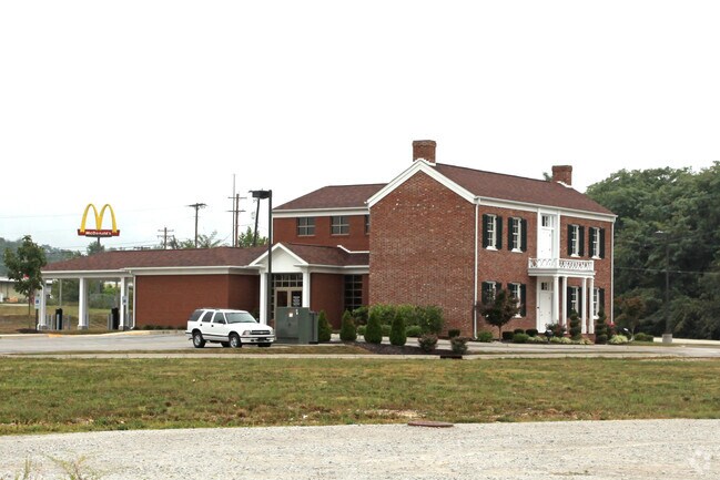
Property Record
5300 State Road 64, Georgetown, IN 47122
NEARBY LISTINGS FOR SALE OR LEASE
Property Detail
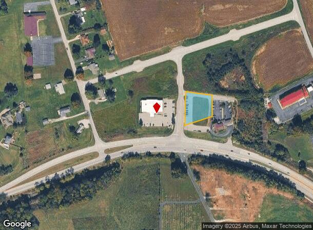
5300 State Road 64
22-02-03-600-120.000-002
SW1/4 36-2-5 0.295 AC.
Commercialacreage
Floyd
X
Indiana
18043C0120E
0.30 AC
2024
Outlying Floyd County
2024
Louisville
071104
Louisville/Jefferson County, KY-IN
DEMOGRAPHICS near 5300 State Road 64
1 mile
3 mile
5 mile
2024 Total Population
2,041
10,472
34,223
2029 Population
2,057
10,552
34,434
Pop Growth 2024-2029
+ 0.78%
+ 0.76%
+ 0.62%
Average Age
42
41
41
2024 Total Households
756
3,866
13,389
HH Growth 2024-2029
+ 0.66%
+ 0.72%
+ 0.58%
Median Household Inc
$91,213
$91,836
$72,515
Avg Household Size
2.60
2.70
2.50
2024 Avg HH Vehicles
2.00
2.00
2.00
Median Home Value
$247,420
$249,824
$229,953
Median Year Built
1992
1990
1978
Nearby Places
Map Layers
Map Styles
 Street
 Aerial
Transit
 Traffic
 Biking
Places
Listings with unknown addresses are not visible on the map
- Restaurants
- Banks
- Shops
- Fitness
- Groceries
PUBLIC TRANSPORTATION
AIRPORT
Louisville Muhammad Ali International
Drive
Walk
Distance
Louisville Muhammad Ali International
30 min
17.7 mi
Nearby Properties
Address
Land Use
TOTAL SIZE
Lot Size
Zoning
Address
Land Use
TOTAL SIZE
Lot Size
Zoning
7,250 SF
4.25 AC
Address
Land Use
TOTAL SIZE
Lot Size
Zoning
39,851 SF
19.68 AC
Address
Land Use
TOTAL SIZE
Lot Size
Zoning
26,864 SF
13.08 AC
Address
Land Use
TOTAL SIZE
Lot Size
Zoning
7,096 SF
2 AC
Address
Land Use
TOTAL SIZE
Lot Size
Zoning
1,458 SF
12.48 AC
Address
Land Use
TOTAL SIZE
Lot Size
Zoning
7,368 SF
14.93 AC
Address
Land Use
TOTAL SIZE
Lot Size
Zoning
3,540 SF
9.97 AC
Address
Land Use
TOTAL SIZE
Lot Size
Zoning
5,824 SF
2.69 AC
Address
Land Use
TOTAL SIZE
Lot Size
Zoning
16,128 SF
3.86 AC
Address
Land Use
TOTAL SIZE
Lot Size
Zoning
5,028 SF
3.33 AC
Address
Land Use
TOTAL SIZE
Lot Size
Zoning
16,920 SF
1.38 AC
Address
Land Use
TOTAL SIZE
Lot Size
Zoning
25,660 SF
2.20 AC
Address
Land Use
TOTAL SIZE
Lot Size
Zoning
15,000 SF
1.69 AC
Address
Land Use
TOTAL SIZE
Lot Size
Zoning
43,060 SF
1 AC
Address
Land Use
TOTAL SIZE
Lot Size
Zoning
39.70 AC
Address
Land Use
TOTAL SIZE
Lot Size
Zoning
4,232 SF
1.99 AC
Address
Land Use
TOTAL SIZE
Lot Size
Zoning
17,050 SF
5.46 AC
Address
Land Use
TOTAL SIZE
Lot Size
Zoning
1,706 SF
11.10 AC
Address
Land Use
TOTAL SIZE
Lot Size
Zoning
3,808 SF
0.76 AC
Address
Land Use
TOTAL SIZE
Lot Size
Zoning
16,960 SF
1.32 AC
Address
Land Use
TOTAL SIZE
Lot Size
Zoning
4,340 SF
21.12 AC
Address
Land Use
TOTAL SIZE
Lot Size
Zoning
26,100 SF
7.37 AC
Address
Land Use
TOTAL SIZE
Lot Size
Zoning
14,742 SF
1.30 AC
Address
Land Use
TOTAL SIZE
Lot Size
Zoning
5,334 SF
3.50 AC
Address
Land Use
TOTAL SIZE
Lot Size
Zoning
8,640 SF
1.31 AC
Address
Land Use
TOTAL SIZE
Lot Size
Zoning
11,200 SF
1.26 AC
Address
Land Use
TOTAL SIZE
Lot Size
Zoning
5,309 SF
16 AC
Address
Land Use
TOTAL SIZE
Lot Size
Zoning
2,614 SF
2.40 AC
Address
Land Use
TOTAL SIZE
Lot Size
Zoning
7,832 SF
4.76 AC
Address
Land Use
TOTAL SIZE
Lot Size
Zoning
5,803 SF
19.31 AC
The World's #1 Commercial Real Estate Marketplace
Connect with us
© 2026 CoStar Group
The information above has been obtained from sources believed reliable. While we do not doubt its accuracy we have not verified it and make no guarantee, warranty or representation about it. It is your responsibility to independently confirm its accuracy and completeness. Any projections, opinions, assumptions, or estimates used are for example only and do not represent the current or future performance of the property. The value of this transaction to you depends on tax and other factors which should be evaluated by your tax, financial, and legal advisors. You and your advisors should conduct a careful, independent investigation of the property to determine to your satisfaction the suitability of the property for your needs.