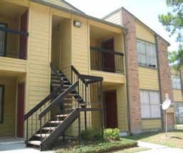
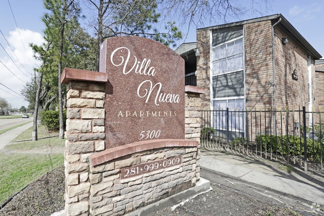
Property Record
5300 W Gulf Bank Rd, Houston, TX 77088

NEARBY LISTINGS FOR SALE OR LEASE
Property Detail
5300 W Gulf Bank Rd
1143570010003
Inwood Estates
Apartment
RES A INWOOD ESTATES
AE
Harris
48201C0465M
Texas
2024
13.95 AC
2025
Acres Homes
532900
Houston
333,286 SF
Houston-The Woodlands-Sugar Land, TX
DEMOGRAPHICS near 5300 W Gulf Bank Rd
1 Mile
3 Mile
5 Mile
2024 Total Population
17,160
125,090
319,700
2029 Population
17,354
127,036
325,049
Pop Growth 2024-2029
+ 1.13%
+ 1.56%
+ 1.67%
Average Age
35
36
35
2024 Total Households
5,565
40,445
105,407
HH Growth 2024-2029
+ 1.06%
+ 1.54%
+ 1.70%
Median Household Inc
$40,753
$45,093
$46,664
Avg Household Size
3.00
3.00
3.00
2024 Avg HH Vehicles
2.00
2.00
2.00
Median Home Value
$163,020
$167,743
$182,021
Median Year Built
1979
1979
1978
Nearby Places
Map Layers
Map Styles
 Street
 Aerial
- Restaurants
- Banks
- Shops
- Fitness
- Groceries
PUBLIC TRANSPORTATION
AIRPORT
George Bush Intcntl/Houston
DRIVE
WALK
Distance
George Bush Intcntl/Houston
23 min
16.5 mi
William P Hobby
DRIVE
WALK
Distance
William P Hobby
41 min
25.0 mi
Freight Ports
Port of Houston
DRIVE
WALK
Distance
Port of Houston
33 min
20.5 mi
Nearby Properties
Address
Land Use
TOTAL SIZE
Lot Size
Zoning
Address
Land Use
TOTAL SIZE
Lot Size
Zoning
397,248 SF
26.37 AC
Address
Land Use
TOTAL SIZE
Lot Size
Zoning
456,294 SF
19.02 AC
Address
Land Use
TOTAL SIZE
Lot Size
Zoning
308,168 SF
21.34 AC
Address
Land Use
TOTAL SIZE
Lot Size
Zoning
409,271 SF
20.70 AC
Address
Land Use
TOTAL SIZE
Lot Size
Zoning
447,480 SF
18.48 AC
Address
Land Use
TOTAL SIZE
Lot Size
Zoning
292,112 SF
4.41 AC
Address
Land Use
TOTAL SIZE
Lot Size
Zoning
257,400 SF
13.34 AC
Address
Land Use
TOTAL SIZE
Lot Size
Zoning
299,640 SF
13.95 AC
Address
Land Use
TOTAL SIZE
Lot Size
Zoning
206,777 SF
8.77 AC
Address
Land Use
TOTAL SIZE
Lot Size
Zoning
201,947 SF
8.80 AC
Address
Land Use
TOTAL SIZE
Lot Size
Zoning
244,727 SF
10.49 AC
Address
Land Use
TOTAL SIZE
Lot Size
Zoning
217,700 SF
16.16 AC
Address
Land Use
TOTAL SIZE
Lot Size
Zoning
437,052 SF
15.90 AC
Address
Land Use
TOTAL SIZE
Lot Size
Zoning
397,012 SF
35.38 AC
Address
Land Use
TOTAL SIZE
Lot Size
Zoning
232,702 SF
14.75 AC
Address
Land Use
TOTAL SIZE
Lot Size
Zoning
194,196 SF
62.19 AC
Address
Land Use
TOTAL SIZE
Lot Size
Zoning
361,869 SF
39.62 AC
Address
Land Use
TOTAL SIZE
Lot Size
Zoning
264,996 SF
18.95 AC
Address
Land Use
TOTAL SIZE
Lot Size
Zoning
403,488 SF
15.07 AC
Address
Land Use
TOTAL SIZE
Lot Size
Zoning
184,169 SF
8 AC
Address
Land Use
TOTAL SIZE
Lot Size
Zoning
265,572 SF
20.64 AC
Address
Land Use
TOTAL SIZE
Lot Size
Zoning
239,721 SF
8.98 AC
Address
Land Use
TOTAL SIZE
Lot Size
Zoning
173,986 SF
9.90 AC
Address
Land Use
TOTAL SIZE
Lot Size
Zoning
302,400 SF
10.29 AC
Address
Land Use
TOTAL SIZE
Lot Size
Zoning
239,058 SF
9.76 AC
Address
Land Use
TOTAL SIZE
Lot Size
Zoning
307,989 SF
16.99 AC
Address
Land Use
TOTAL SIZE
Lot Size
Zoning
283,375 SF
13 AC
Address
Land Use
TOTAL SIZE
Lot Size
Zoning
152,092 SF
10.09 AC
Address
Land Use
TOTAL SIZE
Lot Size
Zoning
153,500 SF
10.65 AC
The World's #1 Commercial Real Estate Marketplace
Connect with us
© 2025 CoStar Group
The information above has been obtained from sources believed reliable. While we do not doubt its accuracy we have not verified it and make no guarantee, warranty or representation about it. It is your responsibility to independently confirm its accuracy and completeness. Any projections, opinions, assumptions, or estimates used are for example only and do not represent the current or future performance of the property. The value of this transaction to you depends on tax and other factors which should be evaluated by your tax, financial, and legal advisors. You and your advisors should conduct a careful, independent investigation of the property to determine to your satisfaction the suitability of the property for your needs.