Property Record
5300 Walnut St, Mckeesport, PA 15132
NEARBY LISTINGS FOR SALE OR LEASE
Property Detail
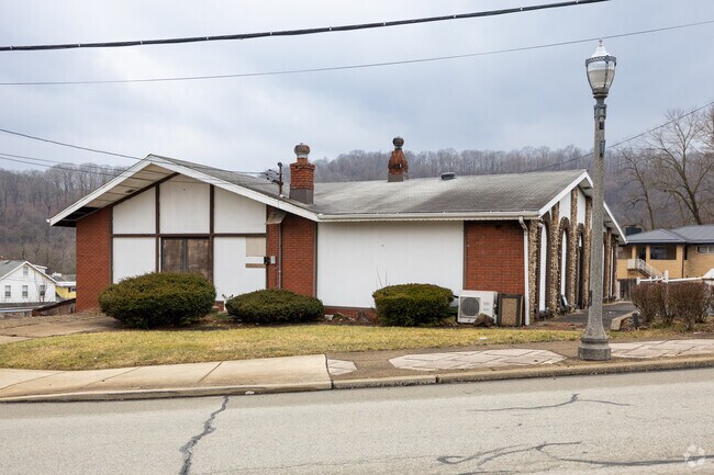
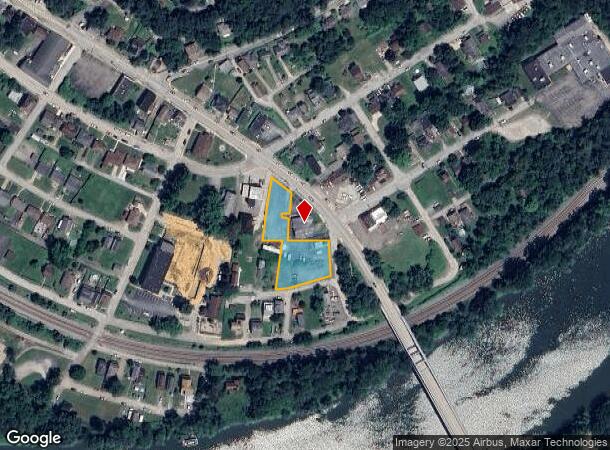
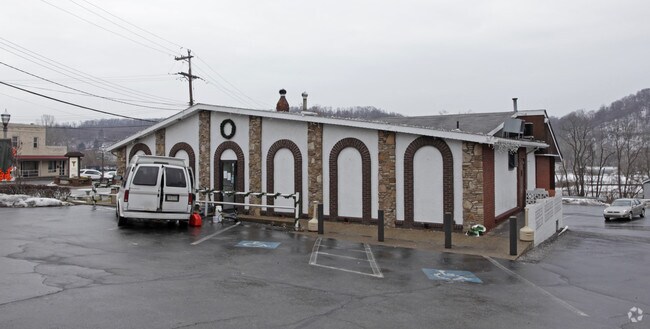
5300 Walnut St
Pittsburgh, PA
IRREG LOT 74.16X195.96X60 WALNUT ST 1 STY BRK V STN & STUCCO BLDG #5300 (RESTAURANT)
0653-A-00155-0000-00
Allegheny
Commercialnec
Pennsylvania
X
155
42003C0504H
0.75 AC
2024
Parkway East Corridor
2025
Pittsburgh
501000
DEMOGRAPHICS near 5300 Walnut St
1 Mile
3 Mile
5 Mile
2024 Total Population
3,254
40,686
101,875
2029 Population
3,175
40,408
100,974
Pop Growth 2024-2029
(2.43%)
(0.68%)
(0.88%)
Average Age
46
44
44
2024 Total Households
1,551
17,879
45,076
HH Growth 2024-2029
(2.45%)
(0.84%)
(0.97%)
Median Household Inc
$55,737
$46,879
$51,136
Avg Household Size
2.10
2.20
2.20
2024 Avg HH Vehicles
2.00
1.00
2.00
Median Home Value
$116,463
$99,355
$119,489
Median Year Built
1954
1953
1955
Nearby Places
Map Layers
Map Styles
 Street
 Aerial
- Restaurants
- Banks
- Shops
- Fitness
- Groceries
PUBLIC TRANSPORTATION
AIRPORT
Arnold Palmer Regional
DRIVE
WALK
Distance
Arnold Palmer Regional
50 min
27.1 mi
Pittsburgh International
DRIVE
WALK
Distance
Pittsburgh International
55 min
35.1 mi
Freight Ports
Port of Baltimore
DRIVE
WALK
Distance
Port of Baltimore
276 min
235.0 mi
Nearby Properties
Address
Land Use
TOTAL SIZE
Lot Size
Zoning
Address
Land Use
TOTAL SIZE
Lot Size
Zoning
5.98 AC
Address
Land Use
TOTAL SIZE
Lot Size
Zoning
49.22 AC
Address
Land Use
TOTAL SIZE
Lot Size
Zoning
10.68 AC
Address
Land Use
TOTAL SIZE
Lot Size
Zoning
11.31 AC
Address
Land Use
TOTAL SIZE
Lot Size
Zoning
29.17 AC
Address
Land Use
TOTAL SIZE
Lot Size
Zoning
46.39 AC
Address
Land Use
TOTAL SIZE
Lot Size
Zoning
43.15 AC
Address
Land Use
TOTAL SIZE
Lot Size
Zoning
969 SF
80.46 AC
Address
Land Use
TOTAL SIZE
Lot Size
Zoning
10.13 AC
Address
Land Use
TOTAL SIZE
Lot Size
Zoning
242.22 AC
Address
Land Use
TOTAL SIZE
Lot Size
Zoning
12.56 AC
Address
Land Use
TOTAL SIZE
Lot Size
Zoning
2.10 AC
Address
Land Use
TOTAL SIZE
Lot Size
Zoning
24.85 AC
Address
Land Use
TOTAL SIZE
Lot Size
Zoning
10.27 AC
Address
Land Use
TOTAL SIZE
Lot Size
Zoning
Address
Land Use
TOTAL SIZE
Lot Size
Zoning
4.59 AC
Address
Land Use
TOTAL SIZE
Lot Size
Zoning
15.07 AC
Address
Land Use
TOTAL SIZE
Lot Size
Zoning
16.87 AC
Address
Land Use
TOTAL SIZE
Lot Size
Zoning
24.86 AC
Address
Land Use
TOTAL SIZE
Lot Size
Zoning
13.93 AC
Address
Land Use
TOTAL SIZE
Lot Size
Zoning
1.96 AC
Address
Land Use
TOTAL SIZE
Lot Size
Zoning
12.60 AC
Address
Land Use
TOTAL SIZE
Lot Size
Zoning
18.54 AC
Address
Land Use
TOTAL SIZE
Lot Size
Zoning
18.97 AC
Address
Land Use
TOTAL SIZE
Lot Size
Zoning
Address
Land Use
TOTAL SIZE
Lot Size
Zoning
9.71 AC
Address
Land Use
TOTAL SIZE
Lot Size
Zoning
5.50 AC
Address
Land Use
TOTAL SIZE
Lot Size
Zoning
Address
Land Use
TOTAL SIZE
Lot Size
Zoning
5.63 AC
Address
Land Use
TOTAL SIZE
Lot Size
Zoning
9.83 AC
The World's #1 Commercial Real Estate Marketplace
Connect with us
© 2026 CoStar Group
The information above has been obtained from sources believed reliable. While we do not doubt its accuracy we have not verified it and make no guarantee, warranty or representation about it. It is your responsibility to independently confirm its accuracy and completeness. Any projections, opinions, assumptions, or estimates used are for example only and do not represent the current or future performance of the property. The value of this transaction to you depends on tax and other factors which should be evaluated by your tax, financial, and legal advisors. You and your advisors should conduct a careful, independent investigation of the property to determine to your satisfaction the suitability of the property for your needs.