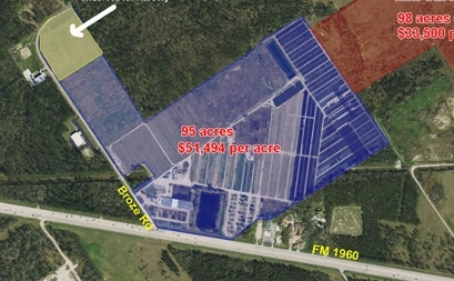
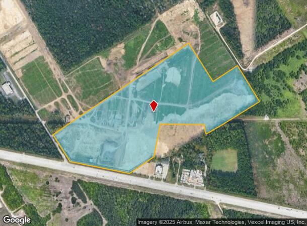
Property Record
5301 Fm 1960 Rd W, Humble, TX 77338
NEARBY LISTINGS FOR SALE OR LEASE
Property Detail
5301 Fm 1960 Rd W
0410810001001
Abst 125 A Barber
Agriculturalland
PT TRS 42A & 43 ABST 125 A BARBER
X
Harris
48339C0725G
Texas
2024
2.90 AC
2025
Kingwood/Humble
240802
Houston
4,940 SF
Houston-The Woodlands-Sugar Land, TX
DEMOGRAPHICS near 5301 Fm 1960 Rd W
1 Mile
3 Mile
5 Mile
2024 Total Population
979
51,144
133,331
2029 Population
1,009
52,139
136,761
Pop Growth 2024-2029
+ 3.06%
+ 1.95%
+ 2.57%
Average Age
35
34
34
2024 Total Households
299
16,105
42,621
HH Growth 2024-2029
+ 3.01%
+ 1.92%
+ 2.55%
Median Household Inc
$74,127
$65,508
$65,058
Avg Household Size
3.20
3.10
3.10
2024 Avg HH Vehicles
2.00
2.00
2.00
Median Home Value
$195,651
$165,169
$169,803
Median Year Built
2003
1995
1999
Nearby Places
Map Layers
Map Styles
 Street
 Aerial
- Restaurants
- Banks
- Shops
- Fitness
- Groceries
PUBLIC TRANSPORTATION
AIRPORT
George Bush Intcntl/Houston
DRIVE
WALK
Distance
George Bush Intcntl/Houston
17 min
8.6 mi
William P Hobby
DRIVE
WALK
Distance
William P Hobby
54 min
33.9 mi
Freight Ports
Port of Houston
DRIVE
WALK
Distance
Port of Houston
42 min
27.8 mi
Nearby Properties
Address
Land Use
TOTAL SIZE
Lot Size
Zoning
Address
Land Use
TOTAL SIZE
Lot Size
Zoning
391,060 SF
32.42 AC
Address
Land Use
TOTAL SIZE
Lot Size
Zoning
355,622 SF
15.78 AC
Address
Land Use
TOTAL SIZE
Lot Size
Zoning
350,423 SF
122.83 AC
Address
Land Use
TOTAL SIZE
Lot Size
Zoning
280,283 SF
16.56 AC
Address
Land Use
TOTAL SIZE
Lot Size
Zoning
334,510 SF
23.54 AC
Address
Land Use
TOTAL SIZE
Lot Size
Zoning
435,650 SF
Address
Land Use
TOTAL SIZE
Lot Size
Zoning
318,000 SF
18.53 AC
Address
Land Use
TOTAL SIZE
Lot Size
Zoning
252,320 SF
22.14 AC
Address
Land Use
TOTAL SIZE
Lot Size
Zoning
242,788 SF
14.72 AC
Address
Land Use
TOTAL SIZE
Lot Size
Zoning
199,368 SF
8.16 AC
Address
Land Use
TOTAL SIZE
Lot Size
Zoning
208,230 SF
14.79 AC
Address
Land Use
TOTAL SIZE
Lot Size
Zoning
175,495 SF
8.92 AC
Address
Land Use
TOTAL SIZE
Lot Size
Zoning
159,480 SF
12.23 AC
Address
Land Use
TOTAL SIZE
Lot Size
Zoning
99,561 SF
11.60 AC
Address
Land Use
TOTAL SIZE
Lot Size
Zoning
146,503 SF
6.12 AC
Address
Land Use
TOTAL SIZE
Lot Size
Zoning
125,674 SF
11.56 AC
Address
Land Use
TOTAL SIZE
Lot Size
Zoning
281,563 SF
19.98 AC
Address
Land Use
TOTAL SIZE
Lot Size
Zoning
152,440 SF
24.67 AC
Address
Land Use
TOTAL SIZE
Lot Size
Zoning
115,000 SF
7.83 AC
Address
Land Use
TOTAL SIZE
Lot Size
Zoning
98,218 SF
29.44 AC
Address
Land Use
TOTAL SIZE
Lot Size
Zoning
106,901 SF
6.70 AC
Address
Land Use
TOTAL SIZE
Lot Size
Zoning
78,116 SF
6.49 AC
Address
Land Use
TOTAL SIZE
Lot Size
Zoning
56,524 SF
9.46 AC
Address
Land Use
TOTAL SIZE
Lot Size
Zoning
79,899 SF
7.05 AC
Address
Land Use
TOTAL SIZE
Lot Size
Zoning
58.19 AC
Address
Land Use
TOTAL SIZE
Lot Size
Zoning
55,580 SF
7.78 AC
Address
Land Use
TOTAL SIZE
Lot Size
Zoning
241,100 SF
20.06 AC
Address
Land Use
TOTAL SIZE
Lot Size
Zoning
75,600 SF
8.36 AC
Address
Land Use
TOTAL SIZE
Lot Size
Zoning
117,500 SF
6.36 AC
Address
Land Use
TOTAL SIZE
Lot Size
Zoning
40,700 SF
8.46 AC
The World's #1 Commercial Real Estate Marketplace
Connect with us
© 2025 CoStar Group
The information above has been obtained from sources believed reliable. While we do not doubt its accuracy we have not verified it and make no guarantee, warranty or representation about it. It is your responsibility to independently confirm its accuracy and completeness. Any projections, opinions, assumptions, or estimates used are for example only and do not represent the current or future performance of the property. The value of this transaction to you depends on tax and other factors which should be evaluated by your tax, financial, and legal advisors. You and your advisors should conduct a careful, independent investigation of the property to determine to your satisfaction the suitability of the property for your needs.