Property Record
Dorchester Rd, North Charleston, SC 29418
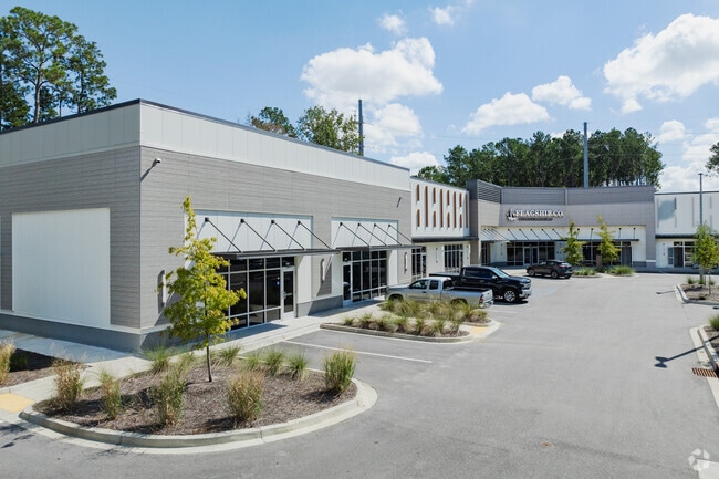
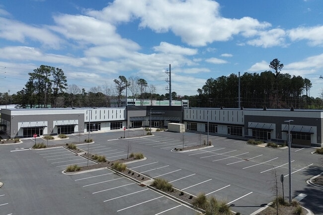
This Property Is For Sale
Current Lease Availabilities
General Retail LEASE
$19.50 SF/YR
1,951 - 11,986 SF
NEARBY LISTINGS FOR SALE OR LEASE
Property Detail
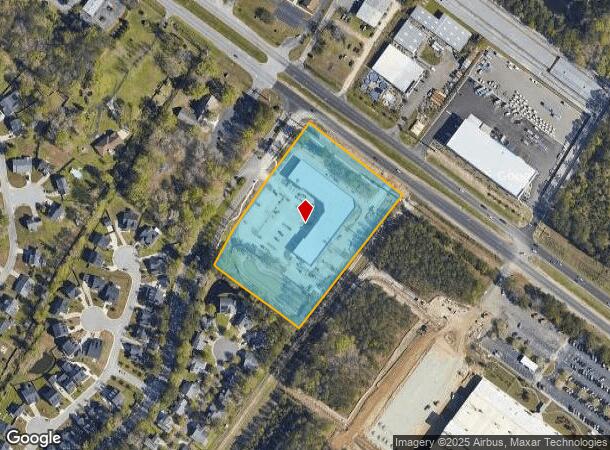
Dorchester Rd
181-00-00-060
TRACT B
Communitycenter
Dorchester
ARE
South Carolina
45019C0290K
4.67 AC
2025
Dorchester County
2025
Charleston/N Charleston
003200
Charleston-North Charleston, SC
9,551 SF
DEMOGRAPHICS near Dorchester Rd
1 Mile
3 Mile
5 Mile
2024 Total Population
9,860
43,570
109,955
2029 Population
10,609
46,692
117,923
Pop Growth 2024-2029
+ 7.60%
+ 7.17%
+ 7.25%
Average Age
37
37
36
2024 Total Households
3,817
16,713
43,171
HH Growth 2024-2029
+ 7.44%
+ 7.09%
+ 7.06%
Median Household Inc
$60,391
$69,576
$61,803
Avg Household Size
2.50
2.50
2.50
2024 Avg HH Vehicles
2.00
2.00
2.00
Median Home Value
$274,274
$258,349
$243,556
Median Year Built
1995
1997
1997
Nearby Places
Map Layers
Map Styles
 Street
 Aerial
- Restaurants
- Banks
- Shops
- Fitness
- Groceries
PUBLIC TRANSPORTATION
COMMUTER RAIL
Charleston Amtrak Station (Palmetto - Amtrak, Silver Meteor - Amtrak)
DRIVE
WALK
Distance
Charleston Amtrak Station (Palmetto - Amtrak, Silver Meteor - Amtrak)
13 min
9.2 mi
AIRPORT
Charleston AFB/International
DRIVE
WALK
Distance
Charleston AFB/International
7 min
4.1 mi
Freight Ports
North Charleston Terminal
DRIVE
WALK
Distance
North Charleston Terminal
15 min
10.2 mi
Nearby Properties
Address
Land Use
TOTAL SIZE
Lot Size
Zoning
Address
Land Use
TOTAL SIZE
Lot Size
Zoning
Address
Land Use
TOTAL SIZE
Lot Size
Zoning
199,300 SF
13.28 AC
Address
Land Use
TOTAL SIZE
Lot Size
Zoning
126,385 SF
13.45 AC
Address
Land Use
TOTAL SIZE
Lot Size
Zoning
48,400 SF
5.76 AC
Address
Land Use
TOTAL SIZE
Lot Size
Zoning
44,300 SF
2.34 AC
Address
Land Use
TOTAL SIZE
Lot Size
Zoning
Address
Land Use
TOTAL SIZE
Lot Size
Zoning
1,286 SF
20 AC
R-2_NC
Address
Land Use
TOTAL SIZE
Lot Size
Zoning
332,013 SF
74.26 AC
R-3_NC
Address
Land Use
TOTAL SIZE
Lot Size
Zoning
5,125 SF
15.99 AC
R-2_NC
Address
Land Use
TOTAL SIZE
Lot Size
Zoning
339,744 SF
17.75 AC
R-1_NC
Address
Land Use
TOTAL SIZE
Lot Size
Zoning
Address
Land Use
TOTAL SIZE
Lot Size
Zoning
102,297 SF
20.14 AC
PDD_NC
Address
Land Use
TOTAL SIZE
Lot Size
Zoning
189,648 SF
40.49 AC
R-1_NC
Address
Land Use
TOTAL SIZE
Lot Size
Zoning
185,000 SF
28.36 AC
R-2_NC
Address
Land Use
TOTAL SIZE
Lot Size
Zoning
99.87 AC
Address
Land Use
TOTAL SIZE
Lot Size
Zoning
Address
Land Use
TOTAL SIZE
Lot Size
Zoning
194,994 SF
21.28 AC
R-4_DC
Address
Land Use
TOTAL SIZE
Lot Size
Zoning
256,996 SF
22.18 AC
R-2_NC
Address
Land Use
TOTAL SIZE
Lot Size
Zoning
256,996 SF
29.96 AC
PDD_NC
Address
Land Use
TOTAL SIZE
Lot Size
Zoning
1,842 SF
17.11 AC
Address
Land Use
TOTAL SIZE
Lot Size
Zoning
3,200 SF
45.22 AC
Address
Land Use
TOTAL SIZE
Lot Size
Zoning
228,432 SF
12.96 AC
B-2_NC
Address
Land Use
TOTAL SIZE
Lot Size
Zoning
Address
Land Use
TOTAL SIZE
Lot Size
Zoning
Address
Land Use
TOTAL SIZE
Lot Size
Zoning
1,152 SF
3.45 AC
Address
Land Use
TOTAL SIZE
Lot Size
Zoning
54,966 SF
4.54 AC
R-1_NC
Address
Land Use
TOTAL SIZE
Lot Size
Zoning
10,950 SF
11.35 AC
Address
Land Use
TOTAL SIZE
Lot Size
Zoning
236,448 SF
12.66 AC
R-2_NC
Address
Land Use
TOTAL SIZE
Lot Size
Zoning
184,860 SF
46.80 AC
I_DC
Address
Land Use
TOTAL SIZE
Lot Size
Zoning
204.26 AC
The World's #1 Commercial Real Estate Marketplace
Connect with us
© 2026 CoStar Group
The information above has been obtained from sources believed reliable. While we do not doubt its accuracy we have not verified it and make no guarantee, warranty or representation about it. It is your responsibility to independently confirm its accuracy and completeness. Any projections, opinions, assumptions, or estimates used are for example only and do not represent the current or future performance of the property. The value of this transaction to you depends on tax and other factors which should be evaluated by your tax, financial, and legal advisors. You and your advisors should conduct a careful, independent investigation of the property to determine to your satisfaction the suitability of the property for your needs.