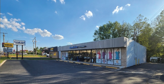
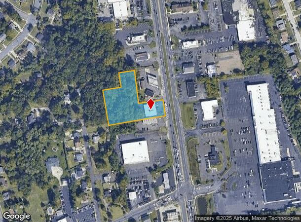
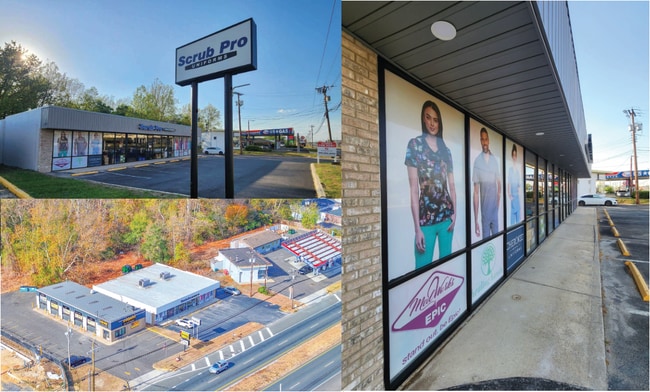
Property Record
5301 Route 42, Blackwood, NJ 08012
Current Lease Availabilities
NEARBY LISTINGS FOR SALE OR LEASE
Property Detail
5301 Route 42
Philadelphia-Camden-Wilmington, PA-NJ-DE-MD
OLD #1101 BHP FORMER: COLOR TILE
18-00111-09-00006-02
Gloucester
Storebuilding
New Jersey
X
6.2
34015C0118E
1.53 AC
2024
Gloucester County
2025
Philadelphia
501203
DEMOGRAPHICS near 5301 Route 42
1 Mile
3 Mile
5 Mile
2024 Total Population
7,713
66,545
179,518
2029 Population
7,892
67,764
182,212
Pop Growth 2024-2029
+ 2.32%
+ 1.83%
+ 1.50%
Average Age
41
41
40
2024 Total Households
2,772
23,762
66,453
HH Growth 2024-2029
+ 2.42%
+ 1.94%
+ 1.54%
Median Household Inc
$108,050
$109,162
$90,328
Avg Household Size
2.70
2.70
2.60
2024 Avg HH Vehicles
2.00
2.00
2.00
Median Home Value
$241,399
$270,710
$248,575
Median Year Built
1967
1981
1980
Nearby Places
- Restaurants
- Banks
- Shops
- Fitness
- Groceries
PUBLIC TRANSPORTATION
COMMUTER RAIL
Lindenwold (NJT) (Atlantic City Line - NJ Transit Commuter Rail (NJ Transit))
DRIVE
WALK
Distance
Lindenwold (NJT) (Atlantic City Line - NJ Transit Commuter Rail (NJ Transit))
18 min
7.4 mi
AIRPORT
Philadelphia International
DRIVE
WALK
Distance
Philadelphia International
30 min
22.8 mi
Freight Ports
South Jersey Port
DRIVE
WALK
Distance
South Jersey Port
1 min
13.3 mi
Nearby Properties
Address
Land Use
TOTAL SIZE
Lot Size
Zoning
Address
Land Use
TOTAL SIZE
Lot Size
Zoning
Address
Land Use
TOTAL SIZE
Lot Size
Zoning
14.21 AC
INS
Address
Land Use
TOTAL SIZE
Lot Size
Zoning
54.91 AC
Address
Land Use
TOTAL SIZE
Lot Size
Zoning
68.30 AC
Address
Land Use
TOTAL SIZE
Lot Size
Zoning
48 AC
R-3
Address
Land Use
TOTAL SIZE
Lot Size
Zoning
64.09 AC
HC
Address
Land Use
TOTAL SIZE
Lot Size
Zoning
38.92 AC
HC
Address
Land Use
TOTAL SIZE
Lot Size
Zoning
32.49 AC
Address
Land Use
TOTAL SIZE
Lot Size
Zoning
33.24 AC
INS
Address
Land Use
TOTAL SIZE
Lot Size
Zoning
69.68 AC
INS
Address
Land Use
TOTAL SIZE
Lot Size
Zoning
38.57 AC
INS
Address
Land Use
TOTAL SIZE
Lot Size
Zoning
26.77 AC
HC
Address
Land Use
TOTAL SIZE
Lot Size
Zoning
14.07 AC
Address
Land Use
TOTAL SIZE
Lot Size
Zoning
18.02 AC
HC
Address
Land Use
TOTAL SIZE
Lot Size
Zoning
28.68 AC
HC
Address
Land Use
TOTAL SIZE
Lot Size
Zoning
1,872 SF
180.40 AC
Address
Land Use
TOTAL SIZE
Lot Size
Zoning
23.61 AC
SC
Address
Land Use
TOTAL SIZE
Lot Size
Zoning
Address
Land Use
TOTAL SIZE
Lot Size
Zoning
20.63 AC
C
Address
Land Use
TOTAL SIZE
Lot Size
Zoning
15.36 AC
Address
Land Use
TOTAL SIZE
Lot Size
Zoning
8.34 AC
INS
Address
Land Use
TOTAL SIZE
Lot Size
Zoning
14.92 AC
HC
Address
Land Use
TOTAL SIZE
Lot Size
Zoning
7.04 AC
INS
Address
Land Use
TOTAL SIZE
Lot Size
Zoning
4.76 AC
Address
Land Use
TOTAL SIZE
Lot Size
Zoning
136,951 SF
18 AC
HC
Address
Land Use
TOTAL SIZE
Lot Size
Zoning
17.53 AC
HC
Address
Land Use
TOTAL SIZE
Lot Size
Zoning
Address
Land Use
TOTAL SIZE
Lot Size
Zoning
13.69 AC
CC
Address
Land Use
TOTAL SIZE
Lot Size
Zoning
15.45 AC
HC
Address
Land Use
TOTAL SIZE
Lot Size
Zoning
19.86 AC
HC
The World's #1 Commercial Real Estate Marketplace
Connect with us
© 2025 CoStar Group
The information above has been obtained from sources believed reliable. While we do not doubt its accuracy we have not verified it and make no guarantee, warranty or representation about it. It is your responsibility to independently confirm its accuracy and completeness. Any projections, opinions, assumptions, or estimates used are for example only and do not represent the current or future performance of the property. The value of this transaction to you depends on tax and other factors which should be evaluated by your tax, financial, and legal advisors. You and your advisors should conduct a careful, independent investigation of the property to determine to your satisfaction the suitability of the property for your needs.